Numerical Modelling For Weather Prediction In Hong Kong
Introduction | Atmospheric Numerical Modelling | NWP at the Hong Kong Observatory | Choices of Domain and Coordinates | Model Initialization | Operational Implementation | Looking Ahead
Introduction : Hong Kong is located at the southern rim of the East Asian continent, in the land of the Asian monsoon and bordering the South China Sea. Its climate is subjected to the vagaries of both tropical and extratropical weather systems. The presence of hilly terrain and large land-sea contrast also gives rise to complex small-scale atmospheric circulations, which in turn lead to significant variations in weather conditions within Hong Kong. As such, suitable forecasting tools are needed to encompass the full range of vastly different meteorological factors over a broad range of spatial scales, from synoptic systems over the expanse of the continent down to local systems arising from orographic influence.
Atmospheric Numerical Modelling : Weather stems from the constant evolution of the atmosphere governed by physical laws. Using high-speed computers to solve a complex set of mathematical equations that represents the governing laws, numerical weather prediction (NWP) is a technique for simulating the atmospheric evolution in order to predict the resultant weather changes. The variables involved in the equations include wind, temperature, pressure, moisture content, etc. In principle, given the initial and boundary conditions, the atmospheric variables can be numerically solved as functions of time and form the basis of weather forecast. In the model, the state of the atmosphere at any given instant is represented by the values of the meteorological parameters at systematically arranged points set up within a three-dimensional grid. The denser the set of grid points, the finer the model resolution and the more details in the future state of the atmosphere can be described, but the computational demand is also substantially higher. However, there are uncertainties pertaining to forecasting different weather phenomena owing to the fact that the nature of the atmosphere is chaotic. In general, it is more difficult to make accurate forecasts for fast-changing and small-scale weather phenomena (such as tornado, torrential rain and windshear). It is also inevitable that uncertainties in forecast grow with the length of the forecast time. Today’s scientific and physical understandings to these weather phenomena are not fully adequate that approximations and assumptions are included in the formulas and schemes adopted in models. To provide weather forecast in time in an operational environment, the computational demand has to be reduced by further simplification of the equations. As such, the numerical simulation will never be a perfect representation of the real atmosphere.
NWP at the Hong Kong Observatory : Over the years, the Hong Kong Observatory has been receiving and making use of NWP data provided by overseas weather centres. For prognosis of large-scale weather systems such as cold surges associated with the winter monsoon, the forecast results are generally satisfactory. However, the relatively coarse resolution of these NWP data often fails to resolve the meso-/small-scale systems (e.g. rainstorms) that play a crucial role in the generation of inclement weather conditions. In an attempt to improve local weather forecasts from the guidance of higher resolution models, the Observatory operates an own suite of high resolution regional numerical weather prediction models in support of local weather forecast. The following is the history of the Observatory's NWP models:
| Year | Operational Regional Numerical Weather Prediction Model Suites in HKO |
| 1999 – 2010 | Operational Regional Spectral Model (ORSM) was deployed on a vector computer. It was replaced with a parallel version of the model in 2008 and put to run on a server cluster. |
| 2010 – | Atmospheric Integrated Rapid-cycle (AIR) was deployed on a server cluster. |
| 2014 – | AViation Model (AVM) is operated on a server cluster and provides tailored aeronautical weather forecast products for the Hong Kong International Airport. |
| 2022 – | Asian Aviation Meteorological Centre WRF (AAMC-WRF) is operated on a server cluster and provides large-area mesoscale weather forecasts as the outer domain of AIR. |
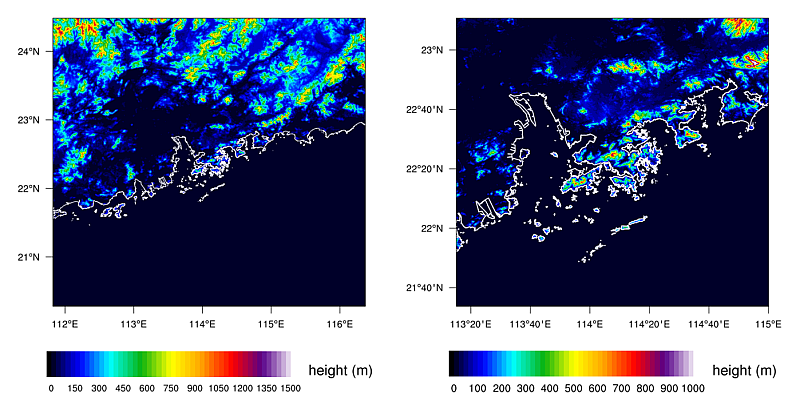
Choices of Domain and Coordinates : AIR currently comprises a smaller but higher resolution (2-km) inner domain covering Hong Kong and its neighbouring areas, and a larger but coarser resolution (10-km) outer domain covering East Asia and the western Pacific (Fig.1). AVM has “nested” grids, comprising a 600-metre resolution outer domain embedding an inner domain with very high resolution at 200 metres (Fig.2).
| AIR Outer Domain (AAMC-WRF) |
AIR Inner Domain (RAPIDS-NHM) |
AVM Outer Domain (AVM-PRD) |
AVM Inner Domain (AVM-xHK) |
|
| Horizontal Resolution | 10 kilometres | 2 kilometres | 600 metres | 200 metres |
| Number of horizontal grid points | 1251x1101 | 305x305 | 581x581 | 581x581 |
| No. of vertical levels | 42 | 60 | 42 | 55 |
| Map Projection | Mercator | |||
| Physical Processes | Radiation exchange, different phases of water, energy redistribution brought by convection in cumulonimbus cloud, kinetic energy associated with turbulence, transportation of moist energy, and exchange of various physical quantities between the ground surface and the atmosphere in flux form. These physical processes are all very complicated and are handled in the model by various parameterisation schemes. Among them, only the AIR outer domain requires a convective parameterisation while the rest of the models has high enough horizontal resolution to resolve explicitly convection activities. | |||
| Boundary Condition - Regional NWP model requires extra values on grid points at its domain boundaries in order to solve its equations. | The model takes its boundary from model output of major global NWP centres (such as ECMWF and NCEP). Surface elements and upper air elements on pressure levels up to 15 hPa (around 28 km above sea level). | Using output of the AIR outer domain. | Using output of AIR inner domain. | Using output of AVM outer domain. |
|
|
Model Initialization : An accurate description of the actual weather condition is an important first step towards a good forecast. Observations obtained from overseas sources as well as from local networks are quality-checked to remove doubtful or erroneous data. The observational data are then ingested into the first-guess or model background for objective analyses. Currently a three-dimensional variational (3DVAR) data assimilation scheme is used to carry out the analysis and prepare the initial fields for the models to start calculating their forecasts. Normally the model uses forecast output from its previous runs or from major global NWP centres, such as the European Centre for Medium Range Forecast (ECMWF) or the National Center for Envrionmental Prediction (NCEP), as the first-guess. The AIR outer model output is used to drive the 2-km inner model which subsequently drives the AVM models.
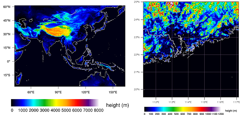
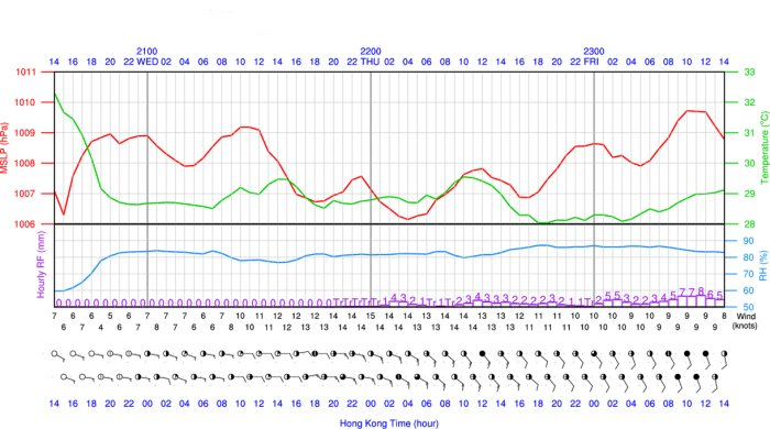
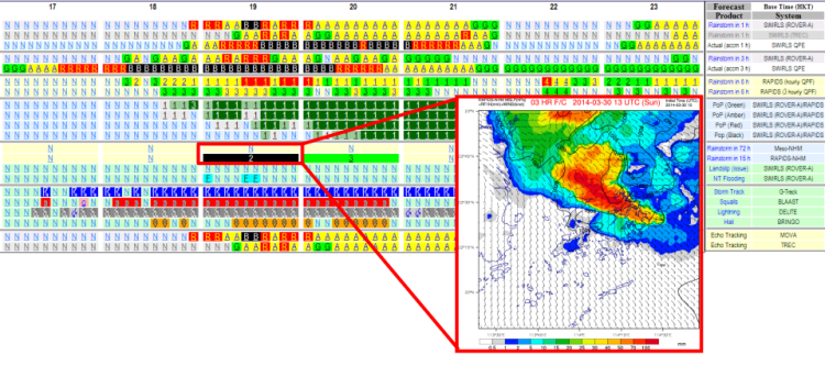
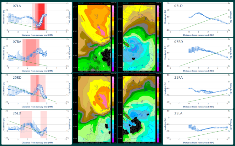
Operational Implementation : The main objective of HKO’s operational regional models is to provide short-range weather forecasts within the next few days. The AIR outer model is run eight times a day at 00, 03, 06, 09, 12, 15, 18 and 21 UTC to provide 84-hour forecasts. The AIR inner model is run every hour to provide 15-hour forecasts. AVM’s two models are run every hour to provide at most 12-hour forecasts. Graphical products are generated to facilitate forecasters' interpretation. Forecast elements including surface wind, temperature, humidity, cloud cover and cumulative rainfall over Hong Kong are extracted from the model output to support local weather forecasts. These information are customized and packaged as time series for visualization (Fig.3). Other derived products include regional temperature forecasts, vertical profiles, meteorograms and a selection of specially prepared weather maps. For short-range warning of heavy rain and thunderstorms, the AIR inner model forecasts are integrated with the nowcasting system for a combined display of operation-critical information (Fig.4). In respect of aviation weather, tailored forecast products (Fig.5) making use of the AVM inner model have been developed for professional users.
Looking Ahead : HKO has been running regional numerical weather prediction models since the late 1980s. Constrained by available computer speed and memory resources of the time, the NWP model implemented by HKO could only simulate a limited region of the atmosphere using a 100 km by 100 km grid. While there has been a significant advancement in operational model resolution all the way down to the current level, there is still room for improvement for a model to depict accurately the weather in a city of complex terrain and coastline as well as high urbanisation such as Hong Kong. With the aim of providing more quantitative and location-specific guidance on inclement weather events and smart city service, the Observatory has been experimenting with more advanced regional models and exploring the feasibility of implementing such models operationally.
Model physics will become more sophisticated as model resolutions increase further, which poses even more stringent requirement on data assimilation schemes to generate better model initial field. New data types at irregular hours from non-conventional sources such as rapid scanning data from meteorological satellites, weather observation from aircraft and tropical cyclone reconnaissance flight data using dropsonde are being collected by HKO in recent years. Further studies need to be conducted carefully for the effective use of these new type of data by NWP.
Despite advancement in technology, computer models' accuracy is still limited by many factors, inter alia, the amount of observational data, model resolution and how well the computer model simulates different physical processes and the topography. It is quite common to obtain different forecasts from different computer models.
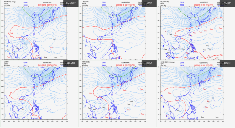
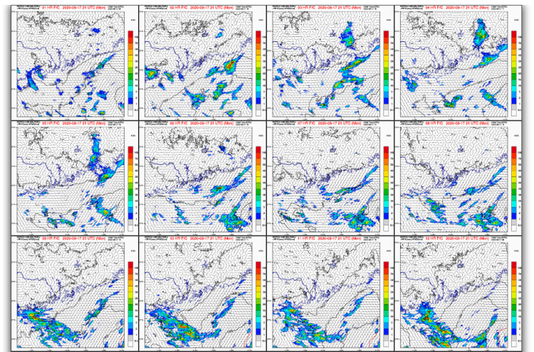
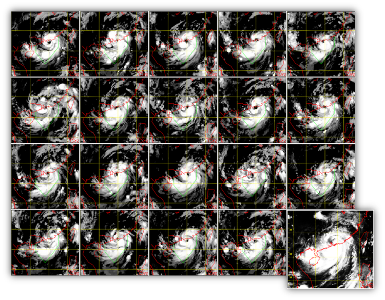
With climate change, occurrence of extreme weather has become more frequent than ever. This makes perfect weather forecasts even more difficult even with the state-of-the-art computer models. One of the most important directions in forecasting technology development is the use of ensemble forecasts and probabilistic forecasts. HKO also attempts to make use of ensemble forecasts to enhance the capability in forecasting. Ensemble forecast method consists of three different types. The first type is to analyze and synthesize forecasts produced for the same valid time by different models (Fig.6). The second type is to analyze and synthesize the forecasts produced for the same valid time by a single model, but were computed at earlier initial times (Fig.7). The third type is to run the same model many times, each with slightly altered initial condition, and compare the output of these different forecasts for the same valid time (Fig.8). All these allow the forecasters to look for features in common or similar trends among different model outputs, so that they can identify the most probable scenario. With ensemble forecasts, forecasters can evaluate the chance of occurrence of various weather situations. This allows them not only to make their forecasts based on the most probable scenario, but also to use probabilities to articulate those that are less likely yet with potentially larger impact. We found from previous verification results that such ensemble forecast method could effectively reduce the average errors of forecasts and improve the overall forecast accuracy.