Radiation Tidbits - Non-ionizing radiation an invisible partner in weather observation
Written by: Yeung Siu-wai
Non-ionizing radiation (NIR) consists of electromagnetic waves which do not have enough energy to remove electrons from atoms when they interact with matters. Examples of NIR are ultraviolet radiation, visible light, infrared radiation, microwave and radio wave. There are many applications of NIR in daily life, such as wireless communication mentioned in a previous article of this series. In this episode, we will discuss how NIR is used in weather monitoring by the Observatoy.
-
Radar - Radar is an acronym for RAdio Detection And Ranging. The Observatory uses weather radar to detect the location and intensity of rain. Radar emits microwave pulses which penetrate clouds but are reflected by rain droplets. The location and intensity of the rain can thus be determined based on the strength and travel time of the reflected pulses.
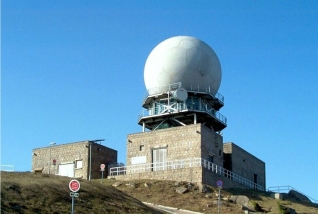
Weather radar at Tai Mo Shan -
LIDAR - LIght Detection And Ranging (LIDAR) systems are employed by the Observatory in detecting windshear near the Hong Kong International Airport. Unlike conventional weather radar which uses microwave, a LIDAR emits infrared radiation to detect the movement of dust particles or aerosols (suspended particulates) in the air. LIDAR operates best under rain-free conditions and reveals weather phenomena invisible to the human eye such as windshear and turbulence.
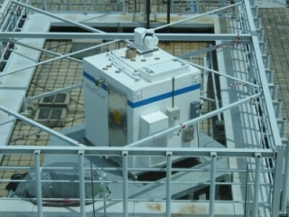
LIDAR at the Hong Kong International Airport -
Meteorological satellite - Meteorological satellites carry onboard sensors which detect different kinds of radiation emitted from the earth. Cloud images are available day and night through sensing the infrared radiation emitted from the cloud tops. High and low clouds can be differentiated because the energy spectrum of the infrared radiation emitted by the cloud top is related to its temperature, which is cooler for high cloud and warmer for low cloud. The identification of high clouds is especially useful in locating highly convective weather systems such as tropical cyclones.
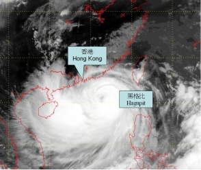
Satellite infrared imagery of Typhoon Hagupit taken on 23 September 2008
[The imagery was originally captured by Multi-functional Transport
Satellite-1R (MTSAT-1R) of Japan Meteorological Agency (JMA)] -
Upper-air weather measurement - The Observatory conducts upper-air weather measurements at the King's Park Meteorological Station twice a day. In an upper-air sounding, a helium-filled balloon carries a radiosonde and a global positioning system (GPS) receiver up through the sky. Equipped with pressure, temperature and humidity sensors, the radiosonde sends back all measured data to the ground station using radio wave for communication. The GPS receiver detects microwave signals from GPS satellites to track the ascent path, information of which can be used to deduce the wind direction and wind speed at different altitudes.
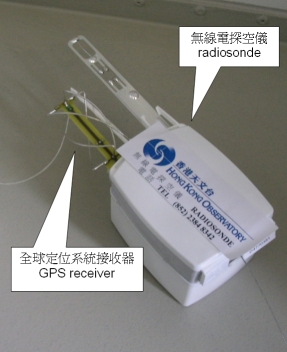
Both the radiosonde and GPS receiver make use of NIR when probing the
upper atmosphere
 Back to Top