Weather On Wings
| Newsletter for the Aviation Community | No. 16 - November 2001 |
New products and service development
______________________________________________
Wind chasing over Lantau
P.W. Chan
The Observatory has recently set up three temporary weather stations at Pak Kung Au, Tai Fung Au and Ngong Ping on Lantau to better monitor the effect of terrain on the airflow over Chek Lap Kok and to understand in greater detail the weather patterns associated with pilot reports of windshear and turbulence near the airport.
All the three stations are remote, with no supply of electricity and communication line. To overcome the difficulties, we use environmentally friendly wind-powered generators to power the stations. It turns out that the generated power is also sufficient to support radio links and wireless GSM technology for communicating the weather data back to the Observatory.
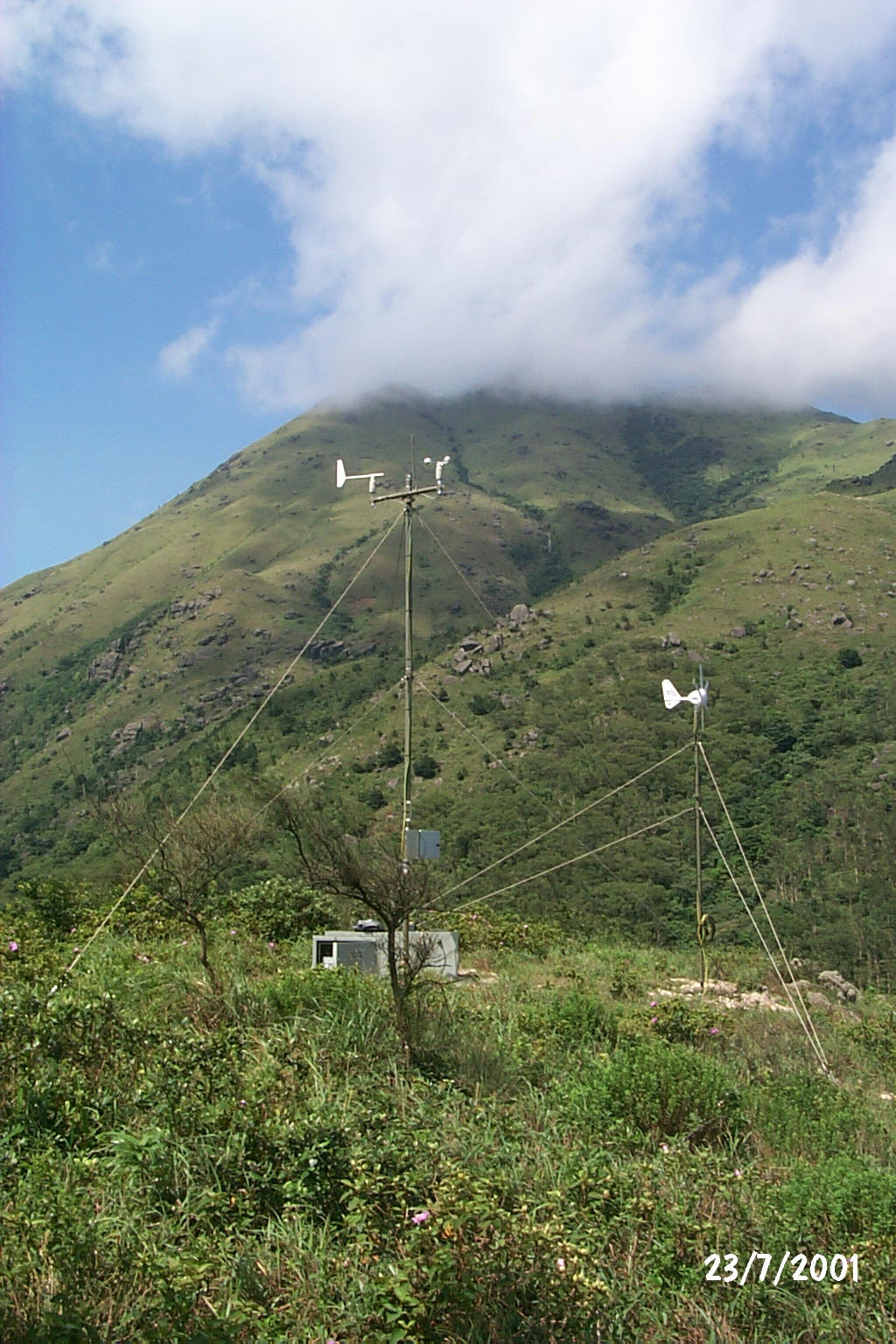
Fig. 1 Temporary weather station at Pak Kung Au
(anemometer to the left and wind-powered generator to the right).
Broadband access for the aviation community
L.O. Li
Since the launch of broadband access to the Aviation Meteorological Information Dissemination System (AMIDS) in July 2001, 15 aviation-related organizations have already started using the service. The downloading time for weather information for many products has been reduced from minutes previously to seconds now. AMIDS provides aviation users with the latest weather observations, forecasts and warnings, latest tropical cyclone information, weather charts as well as flight documents for aircraft departing from the Hong Kong International Airport.
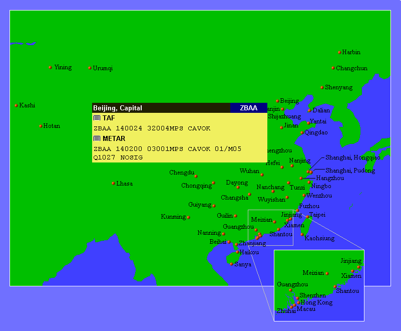
Fig. 2 A new product on AMIDS (currently on trial): latest weather reports and forecasts for aerodromes in China.
Smaller size, higher flexibility
- Trial use of binary-form weather charts from London World Area Forecast Centre
P.W. Chan
The Hong Kong Observatory (HKO) started the trial use of binary-form (BUFR) encoded weather charts from London World Area Forecast Centre (WAFC) since the middle of this year.
Satellite communication is an important means for transmitting weather data in the aviation community. Like other weather centres, HKO makes use of the significant weather (SIGWX) charts received from satellite broadcasts by WAFCs to prepare flight documents. These weather charts are currently transmitted as graphical files and have rather large data size. Taking SIGWX charts from WAFC London as an example, they make up a total data volume of about 14 MB on a typical day. Moreover, they are received 'as-is' and cannot be customized to suit the specific needs of individual weather centres.
In an attempt to further improve its satellite broadcast, WAFC London started a trial dissemination of the significant weather charts in BUFR earlier this year. The encoded data are considerably smaller in size, requiring only a total volume of around 1 MB every day for a suite of weather charts covering the whole globe. They can also be modified with special computer software, for example, to adjust weather features to reflect the latest development or to add annotation, thus solving the problem in adjusting these charts.
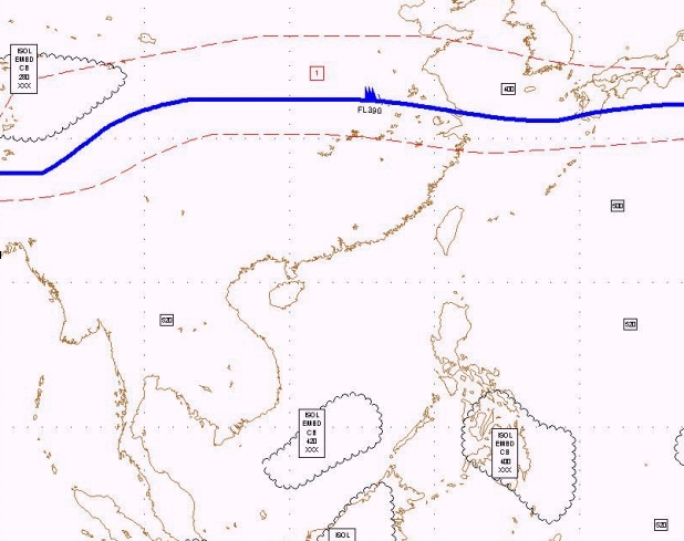
Fig. 3 A sample of BUFR weather chart from WAFC London.
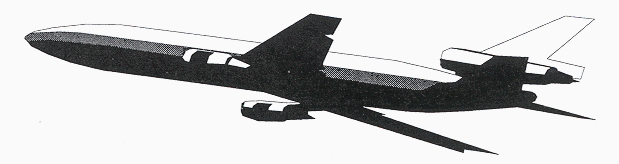
Automatic weather reporting by aircraft
L.O. Li
With the assistance of the Bureau of Meteorology of Australia and National Weather Service of USA, a number of Australian and US airlines are now making AMDAR (Aircraft Meteorological Data Relay) observations flying in and out of Hong Kong. Under the scheme, wind and temperature reports are transmitted automatically by an on-board system. In October 2001, the Hong Kong Observatory (HKO) receives each day over 150 weather reports made by aircraft while landing at and departing from the Hong Kong International Airport. On the home front, HKO has been exploring since late 2000 with local airlines to start an AMDAR programme for Hong Kong. With the kind assistance of Cathay Pacific, an Airbus has recently been equipped with the AMDAR reporting software in preparation for an observation trial.
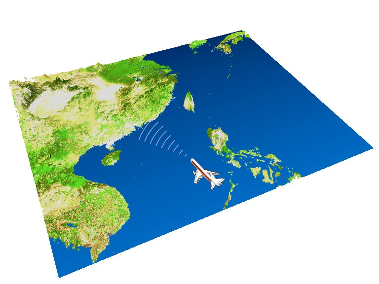
Fig. 4 Under the AMDAR programme, an aircraft sends out weather reports automatically.
Airship over the harbour
K.S. Leung
An airship flew over Hong Kong during the period August to November 2001 to promote commercial activities. During this period, the forecaster at the Observatory's Airport Meteorological Office provided telephone consultation on winds and significant weather relevant to the flight operation.
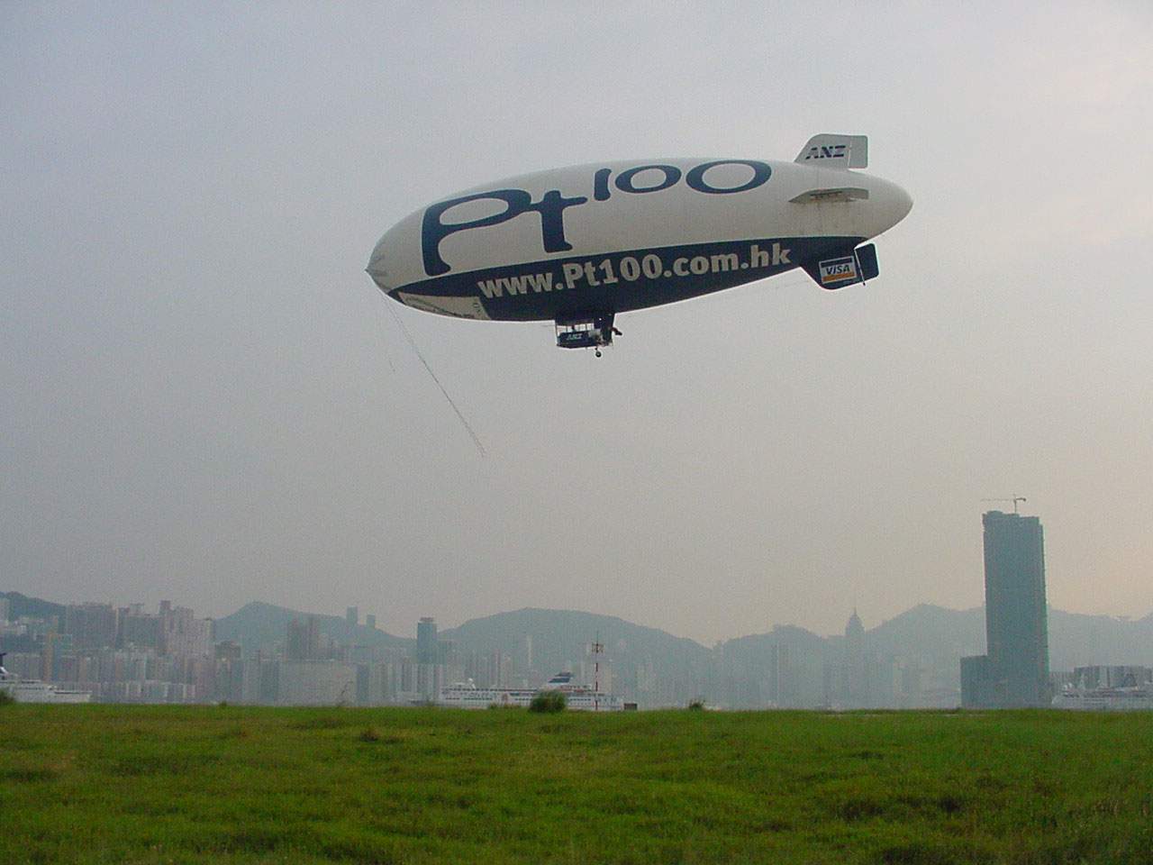
Fig. 5 The airship, pictured here flying over the Victoria Harbour, makes use of weather information provided by the Observatory.
(Photo: Courtesy of Captain M. Nerandzic)
Weather observations at the airport
___________________________________________
Rainbow over the airfield
C.S. Yuen
Rainbow appears when the observer has his back to the sun and small raindrops in front of him. When beams of sunlight enter the raindrops they are split into bundles of coloured rays after refractions and reflections.
Rainbows sometimes appear as two concentric bows with the inner one called the primary bow and the outer one the secondary bow. Arising from two internal reflections, the secondary bow appears less bright and has the colour sequence reversed.
You may notice that it is brighter inside the bow than outside. This is also a result of refractions and reflections in the rainbow formation process.
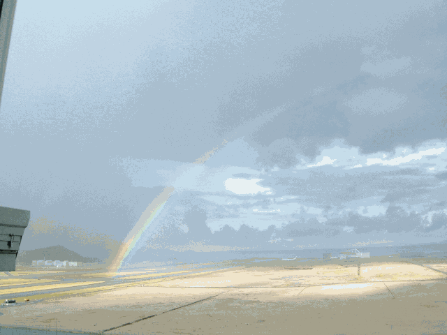
Fig. 6 A rainbow over the southern runway of the airport (a secondary rainbow can vaguely be seen to the left).
(Photo: Courtesy of C.S. Yuen. Taken at 8:00 a.m. on 11 August 2001, looking towards the southwest)
Visibility at the airport
David Tse
There are more occurrences of fog/mist/drizzle at the Hong Kong International Airport for the first half of the year, whereas haze occurrences become more prevalent for the latter half. Figure 7 shows the monthly distribution of occurrence in number of hours of fog/mist/drizzle (green columns) and haze (red columns) at the airport during the period from April 1997 to March 2001. Fog/mist/drizzle are associated with humid weather whereas haze is associated with relatively dry weather.
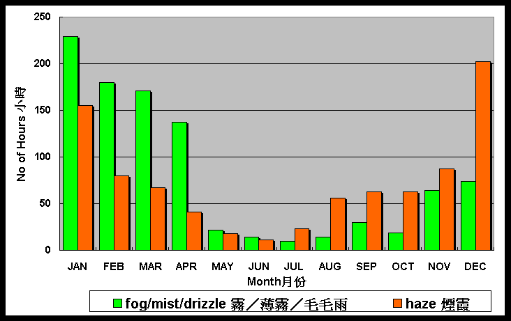
Fig. 7 Monthly distribution of low visibility at Chek Lap Kok (Apr 1997 Mar 2001).
Severe weather
_____________________________________
Typhoon Utor
S.Y. Lau
Typhoon Utor approached Hong Kong in early July 2001. In the morning of 6 July it made landfall east of Hong Kong and soon weakened into a Severe Tropical Storm. As Utor departed, the gale force winds around its centre also moved away from Hong Kong. Local winds started to moderate and the No. 8 Gale or Storm Signal was replaced by the No. 3 Strong Wind Signal in the afternoon.
Utor was well inland Guangdong about 200 km away from Hong Kong when an intense rainband in the outer periphery affected the airport in the late evening.
Southerly gales brought severe windshear and turbulence to the airport. As southerly gales blew across the northeast-southwest oriented hilly ranges over Lantau, streaks of low wind flow emanated from the hills while streaks of high wind flow appeared downwind of the gaps. These high and low wind streaks crossed the approach and departure paths of the airport in pulses, leading to intermittent severe windshear and turbulence. Capturing these pulses, the Terminal Doppler Weather Radar (TDWR) issued microburst alerts intermittently throughout the evening of 6 July 2001. At the height of the episode, shear of up to 50 knots were detected by the TDWR (see figure 8). It was observed that terrain-induced windshear under high southerly winds was generally stronger over the southern runway than the northern runway, a result of the proximity of the former runway to the terrain of Lantau.
Utor was unusual in that it took more than 40 hours to dissipate after landfall, breaking the previous record of 30 hours set by Typhoon Hope in 1979.
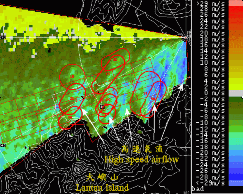
Fig. 8 Low-level radial winds observed by the TDWR at 10:09 p.m. on 6 July 2001.
"Microburst" !
S.Y. Lau
It lurks in the sky and when the time is right, it rushes towards the ground causing significant downdraughts and changes in head wind. Microburst first coined by T. Fujita, is so dangerous that every pilot would try to avoid it, especially during take-off and landing. Over the years, considerable progress has been made in the development of detection systems, both ground-based and on-board aircraft. In Hong Kong, apart from the Terminal Doppler Weather Radar (TDWR) at Tai Lam Chung which keeps a close watch on microbursts within 3 nautical miles from the airport, the Tai Mo Shan Doppler weather radar, in operation since 1999, provides further support in monitoring severe weather at a distance from the airport.
On 23 June 2001, due to subsidence (descending motion of the air over a rather broad area) ahead of Typhoon Chebi, heat showers formed over inland Guangdong and moved south to affect Hong Kong in the evening. These heat showers later developed into a northwest-southeast oriented squall line. Meanwhile, with moist southwesterlies feeding into isolated convective storm over Pearl Estuary, another squall line developed explosively. This latter squall line moved southeast to Lau Fau Shan and merged (to form an "L" shape, see figure 9) with the main squall line. Gusts reaching 36 knots were subsequently recorded at Blank Point (BP).
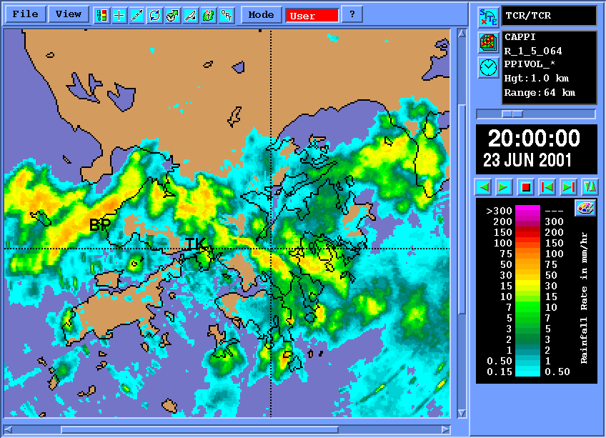
Fig. 9 Radar picture at 12:00 UTC (8:00 p.m. Hong Kong Time) on 23 Jun 2001.
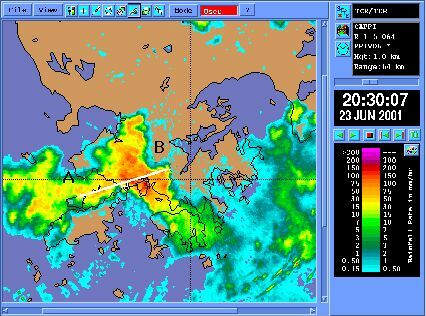
Fig. 10 Radar picture at 12:30 UTC (8:30 p.m. local time) on 23 Jun 2001.
At the point where the two squall lines met each other, the rain was most intense. The squall line complex continued to move southeast. At about 12:30UTC (8:30 p.m. local time), an area of intense rain, over 100 mm/h, moved to just south of Ting Kau (TK, see figure 9 for location) to cross the approach path of runway 25R (northern runway) at a time a plane was making an instrumented approach to runway 25R (see figure 10). From the vertical winds re-constructed from the flight data, it is estimated that the downdraught was over 30 knots.
The vertical section of the radar picture along the direction of the approach path (marked A - B in figure 10), together with the winds experienced by the plane, is given in figure 11. The transit of the plane through the northwest-southeast squall line was uneventful, and the head wind changes were not particularly high. However, as the plane approached the intense rain area, winds abruptly backed to northerlies coupled with a rapid increase in downdraught to over 30 knots. As the plane exited the storm into the prevailing southwesterlies, there was a rapid increase in both the head wind and updraught. While the plane did not experience the full force of the storm, the resulting rate of descent of the plane was nonetheless quite phenomenal, exceeding 2,000 feet per minute (see figure 11). One should therefore never treat these storms lightly.
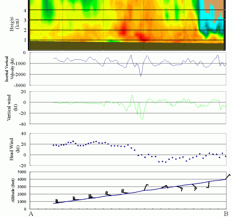
Fig. 11 Integrated picture showing vertical section (along A - B of figure 10) of radar picture at 12:30UTC (8:30 p.m. Hong Kong Time),
vertical velocity of the aircraft, vertical wind derived from flight parameters, head wind derived from on-board wind measurements and variation of on-board winds during the approach.
Visits, meetings and conferences
_____________________________________
Airport Authority Hong Kong visits the Observatory
K.S. Leung
Dr. David Pang, Chief Executive Officer of the Airport Authority Hong Kong (AA), and his staff visited the Observatory's Airport Meteorological Office on 25 September 2001. Matters on enhancing co-operation between AA and the Observatory in respect of provision of weather information were discussed.
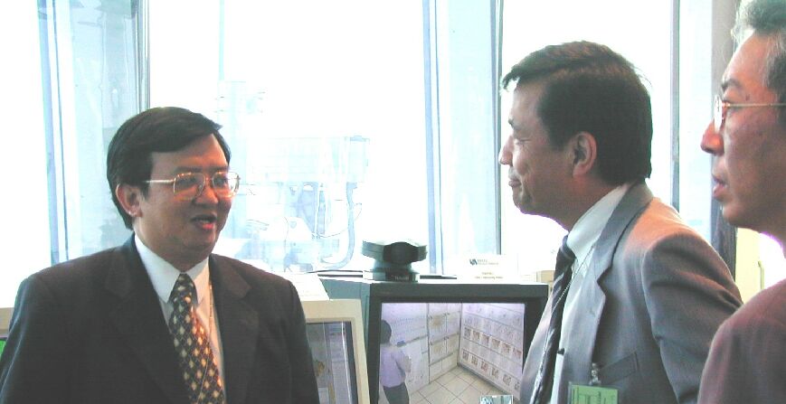
Fig. 12 Dr. H.K. Lam, Director of the Hong Kong Observatory, briefed Dr. David Pang on the services provided by the Airport Meteorological Office.
The Observatory visits Cathay Pacific
S.Y. Lau
The Observatory visited Cathay Pacific Airways at their Cathay Pacific City in Chek Lap Kok in August 2001 to discuss the supply of flight data. The flight data will help the Observatory's work on enhancing its windshear and turbulence alerting service.
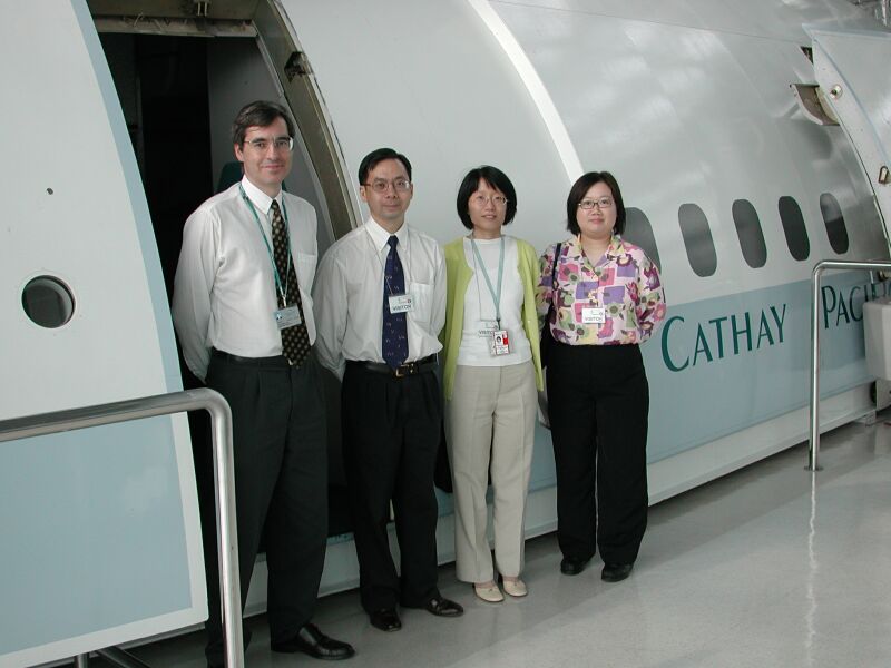
Fig. 13 Picture taken during the visit in August
(from left): Neil Campbell (Corporate Safety Department, Cathay Pacific), B.Y. Lee, Sharon Lau and Olivia Lee (HKO).
Taking the chair
The Observatory's C. M. Shun, Senior Scientific Officer, attended the 5th meeting of the Communications, Navigation and Surveillance / Meteorology Sub-Group under International Civil Aviation Organization (ICAO), held in Bangkok during 16 - 20 July 2001. We are happy to report that he has taken up the chair of the Asia/Pacific WAFS (World Area Forecast System) Transition Task Force from the outgoing Australian expert. Despite the various new tasks that will be laid upon him, Mr. Shun will continue to ensure that relevant meteorological issues and requirements of the local aviation community are reflected to ICAO.
We are also happy to report that the meteorological chapter of the Asia/Pacific Regional Plan for the new Communications, Navigation and Surveillance/Air Traffic Management Systems drafted by the Observatory's H. G. Wai, Senior Scientific Officer, as the Rapporteur of the Meteorological Working Group has been accepted by the meeting. HKO will continue to contribute in this area.
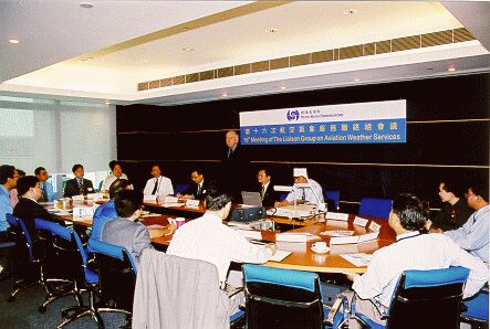
Fig. 14 The 16th Meeting of the Liaison Group on Aviation Weather Services.
The 16th Liaison Group Meeting with the Airlines
K.S. LeungThe 16th Meeting of the Liaison Group on Aviation Weather Services was held on 2 August 2001. Cathay Pacific kindly agreed to provide the venue in Cathay Pacific City at Chek Lap Kok. Topics discussed included the progress in windshear alerting service, Amendment 72 to ICAO Annex 3, re-organization of airspace in the South China Sea, the annual survey on services provided by the Hong Kong Observatory, World Area Forecast System (WAFS) transition matters, the launch of broadband AMIDS and the progress on Automatic Dependent Surveillance/Controller Pilot Data Link Communication (ADS/CPDLC) and Aircraft Meteorological Data Relay (AMDAR).
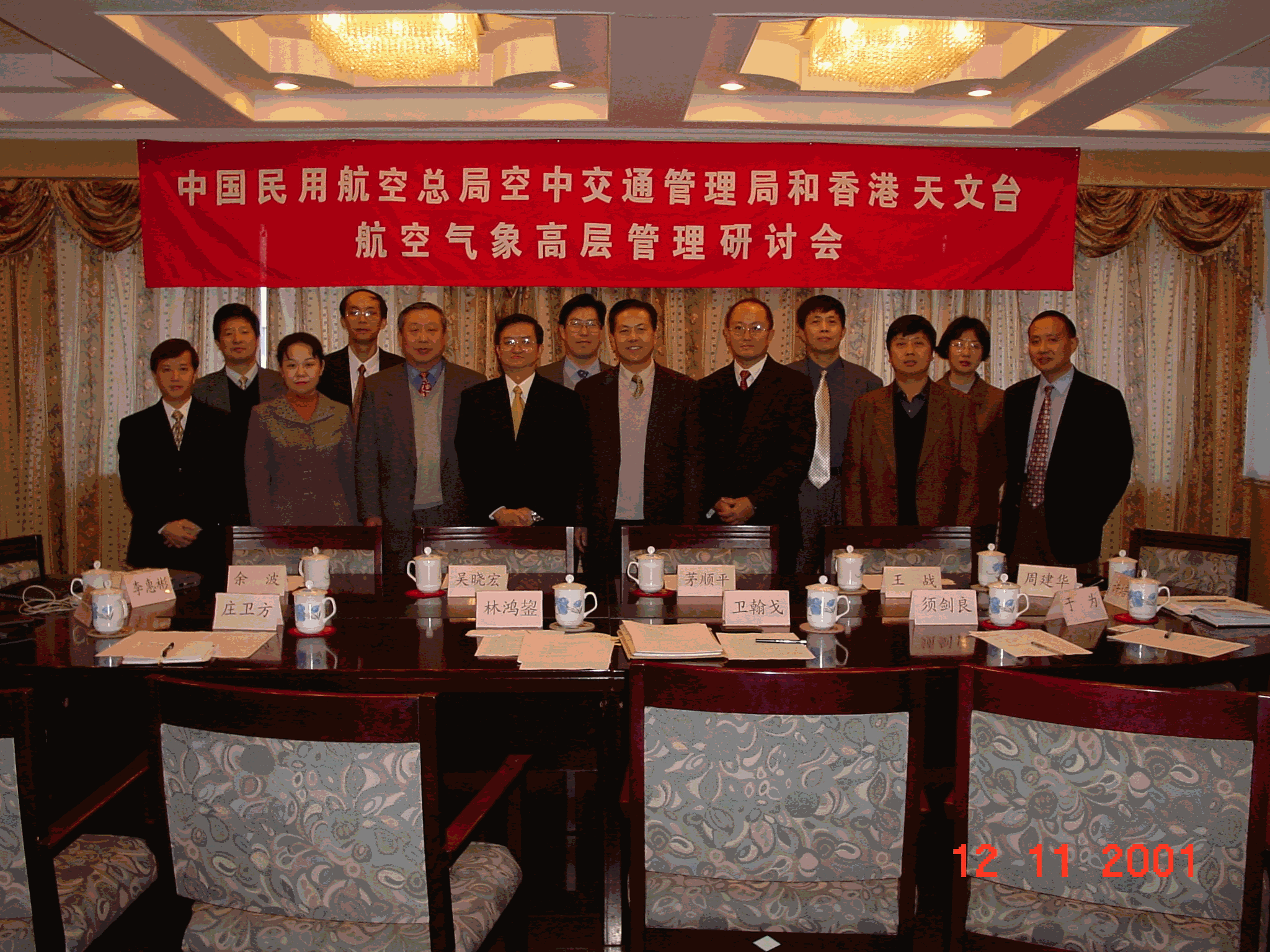
Fig. 15 Meeting on aviation weather services with Air Traffic Management Bureau, Civil Aviation Administration of China, 12 November 2001, Beijing.
Long-term technical cooperation in aviation weather services
The Hong Kong Observatory (HKO) and the Air Traffic Management Bureau (ATMB) of the Civil Aviation Administration of China (CAAC) signed a memorandum on long-term technical cooperation in aviation weather services in 1999. To review the technical cooperation in the past two years and to explore the way ahead, Dr. H.K. Lam, Director of the Hong Kong Observatory, accompanied by Mr. H.G. Wai, Senior Scientific Officer, met with the management of ATMB/CAAC in Beijing on 12 November 2001. At the meeting, both sides expressed satisfaction with the cooperation since the signing of the memorandum, and agreed on enhancing future cooperation in weather data exchange, processing of AMDAR (Aircraft Meteorological Data Relay) data and meteorological research topics of common interest.
Quiz
S.T.Chan
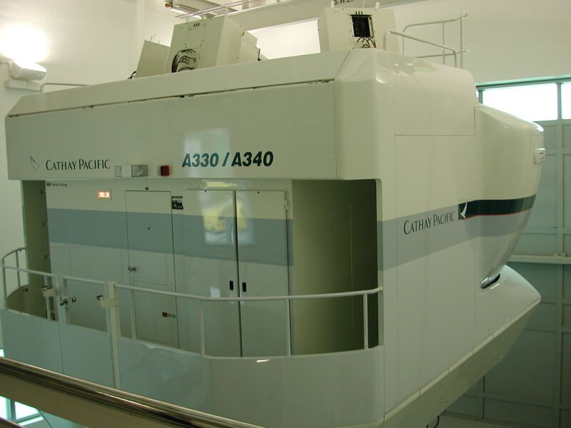
Q.1 What is the box in the picture below? (A) a space ship; (B) a ticketing office; or (C) a flight simulator?
A. a space ship
B. a ticketing office
C. a flight simulator
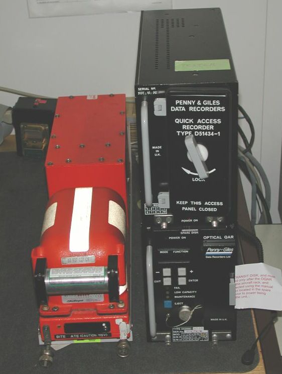
Q.2 Which one is the 'Black Box' in an aircraft? (A) left box; or (B) right box?
A. Left box
B. Right box
Airport Meteorological Office
_____________________________________
Visit airport-restricted area at no peril
P.W. Chan
Visiting the Observatory's Airport Meteorological Office may involve proof of your identity, an application and waiting time, as it is an airport restricted area. But don't worry! We have arranged a "virtual tour for you on the internet. Simply click on the Observatory website at: http://www.weather.gov.hk/aviation/.
Fig. 16 Virtual tour of Airport Meteorological Office on the Observatory's website "Aviation Weather Services".
My summer at the Hong Kong Observatory (HKO)
S. H. Ng
As a second-year mathematics student from the Chinese University, I worked for the HKO this summer. For about two months I was involved in aviation weather related work. My main duty was to assist in computer programming so that forecasters may interactively access data from the wind profilers through the computer network.
As it was my first full-time job, I did not know where to start, not to mention what a wind profiler was all about. Fortunately, HKO colleagues were very helpful and guided me along, so that my work went smoothly. I learned a little more about meteorology and computing along the way.

Fig. 17 S.K. Ng working on a computer program.
The HKO also arranged for the students visits to the Central Forecasting Office, Tai Mo Shan Weather Radar Station and King's Park Weather Station to better understand its work and facilities. These visits were really eye openers, making my summer job a very rewarding one.
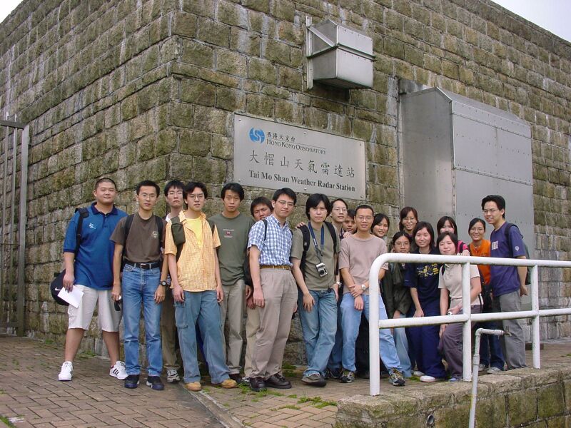
Fig. 18 Visiting the radar station at Tai Mo Shan.
|
Telephone and Fax Numbers
|
|
|
Enquiry on flight documents |
(852) 2910 6922 |
|
Officer-in-charge AMO |
(852) 2910 6300 |
|
Duty Forecaster AMO Fax |
(852) 2910 6920 |
|
Dial-a-Weather |
(852) 187 8200 |
|
Telephone Information Enquiry System |
(852) 2926 1133 |
|
Hong Kong Observatory Home Page |
|
Web Page for Aviation Weather Services |
|
|
http://www.weather.gov.hk/aviation |
|
|
Editor this issue C.H. Ng, W.H. Lui |
|
Email:mailbox@hko.gov.hk
Hong Kong Observatory : 134A Nathan Road, Kowloon, Hong Kong