WEATHER ON WINGS - Newsletter for the Aviation Community
| Newsletter for the Aviation Community |
Issue No. 15 - May 2001 |
Flying to and fro over Lantau
Olivia Lee
You must have heard about the Government Flying Service (GFS). The picture you have in mind may be a helicopter saving hikers from dangerous cliff. You may be interested to know, however, that there is a team of fixed wing aircraft pilots in the GFS, who not only carry out rescue operations but also conduct investigation flights for the Hong Kong Observatory (HKO).
During last August & September and February to April this year, the GFS pilots flew at scheduled times in a twin-engined Jetstream J-41 fixed wing aircraft around Lantau Island to collect wind and temperature data for the HKO. With these data, we can better understand terrain-induced windshear around the airport.
I had the chance of talking to one of the GFS fixed wing pilots, Captain Kit Kwan. In deep blue uniform, Captain Kwan impressed me as sturdily built and full of confidence.
"What is the most difficult part of the flight?" I asked curiously.
"In one of the routes, we have to fly low, at 1000 feet, around Lantau. That we have to pay special attention. Other than this, there is no great difficulty." Captain Kwan continued to explain in earnest.
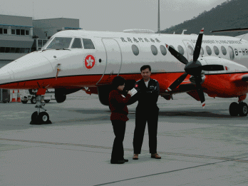
Fig.1 Captain Kit Kwan and the writer in front of the twin-engined Jetstream J41 fixed wing aircraft.
"Unless we have emergency operation, we would adhere to the scheduled investigation flights. Of course we have to check the weather. We cannot fly if the visibility is too low. Every trip takes about one hour and forty-five minutes. The co-pilot/crewman takes readings of wind direction and speed during the flight. If the aircraft encounters windshear or turbulence, that would be recorded as well. After the plane lands, it takes only about 10 minutes to download temperature data from the Flight Deck Recorder (FDR or Black Box)."
"Can I take a look at the Black Box ?" I definitely wanted to take a look at the FDR.
Captain Kwan replied with a smile, "The Black Box of our fixed wing is orange in colour, not black. It s located in the rear part of the aircraft."
I watched the GFS engineers open up the rear part of the aircraft and download data from the Black Box using a laptop PC. Another set of valuable weather data ready for our use!
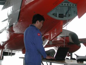

Fig.2 A GFS engineer opens up the rear part of the fixed wing and downloads data from the "Black Box"(inset shown by arrow) inside.
Feeling the Heat
P.W. Chan
Temperatures not only tell us how warm or cool the weather is. Their changes with height tell us much about the stability of the atmosphere. For instance, cool air under a layer of warm air tends to stay underneath the warm air, resulting in a stable condition called an inversion . This favours the appearance of fog, mist or haze, causing reduced visibility. On the other hand, warm air beneath a layer of cool air tends to rise, resulting in an unstable or convective situation sometimes causing showers and thunderstorms.
Twice a day, the Observatory releases a balloon carrying a radiosonde to measure temperatures aloft, up to ten kilometres or above.
With advances in remote sensing technology, the Observatory is now capable of measuring the temperatures in the lowest 1 km continuously. This is achieved by means of a radio acoustic sounding system (RASS), installed at Sha Lo Wan in February 2001. It works on the principle that the speed of sound changes with temperature, i.e. sound travels faster in warm air than in cold air. The RASS emits sound waves into the air and determines the temperature by tracking the propagation of these waves using radio. It finds applications in the forecasting of low visibility and in windshear alerting.
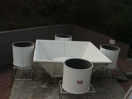
Fig.3 Integrated wind profiler and RASS at Sha Lo Wan. The rectangular antenna in the middle transmits
and receives radio waves. The four cylindrical loudspeakers surrounding it emit sound waves into the atmosphere.
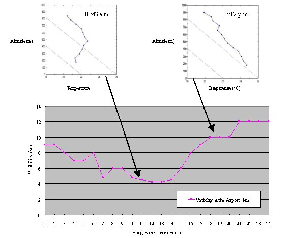
Fig.4 Visibility observed on 22 Feb 2001 at the airport (lower figure), and selected temperature profiles obtained
with RASS (upper graphs). A temperature inversion was observed at 10:43 a.m. when the visibility decreased
to around 4000 m in haze. The temperature inversion dissipated by the evening (6:12 p.m.) following periods of sunshine during the day.
Towards a Green Office
T. L. Cheng
With increasing environmental awareness, more and more organisations are implementing green measures. The Observatory' s Airport Meteorological Office (AMO) is no exception.
In the past, weather information collected by AMO from all over the world was routinely printed, manually sorted and delivered to the forecaster. Thousands of messages were handled this way, day in and day out. Not only time and manpower consuming, this also wasted a lot of paper.
To improve the situation, the Observatory has developed an in-house' Weather Information Display System'. It collects all the relevant data and transmits them via computer network to a server for sorting and processing. The data are then displayed in web-page format to the forecaster through HKO' s intranet.
Since the system went into operation in May last year, demand for computer printouts has greatly decreased, resulting in reduction of over 80 percent of paper use. Apart from environmental conservation, we have also enhanced efficiency.
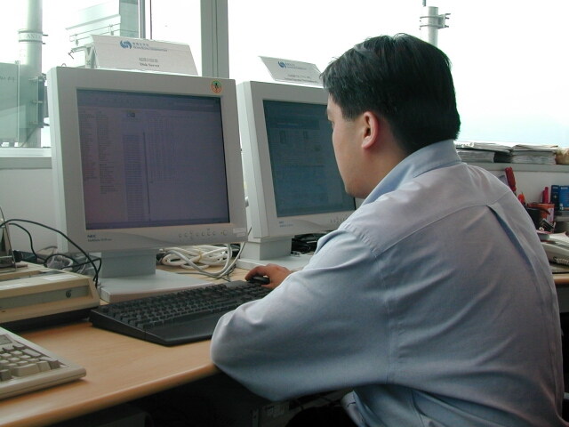
Fig.5 Weather information is now fully online at AMO.
Wind Power Update
K.K. Yeung
The Observatory added another wind-powered generator at Yi Tung Shan, Lantau, in February 2001, making a total of four for its network of automatic weather stations.
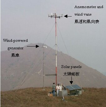
Fig.6 The automatic weather station at Yi Tung Shan is now powered by both wind and solar energy.
Joy And Sweat - Ip King Hung
C.L. Yeung
The Observatory has a maintenance team at the Chek Lap Kok airport. There are two artisans in the team and Mr Ip King Hung is one of them. He has been working in the Observatory for more than 5 years. In this interview, Mr Ip tells us about his work at the airport.
Q: Mr Ip, could you please describe your work at the airport?
A: My work includes maintenance and assistance in the repair of meteorological equipment such as cleaning the runway visual range transmissometers regularly and maintaining the Stevenson screens in a number of automatic weather stations (AWSs) in and around the airport. I also design and make some accessories for the equipment.
Q: It seems to me that you often have to work outdoors.
A: I work outdoors half the time. Sometimes I have to make long and arduous journeys to those remotely located AWSs for emergency repair.
Q: You mentioned that one of your duties is to clean the visual range transmissometers regularly. Could you tell us more about it?
A: A transmissometer is a piece of highly sophisticated optical equipment for measuring the visual range. Its accuracy depends on the cleanliness of the lens, the same way as a pair of soiled glasses will blur one s vision. Therefore, cleaning must be done on time regardless of the weather conditions. The task can be quite demanding as the transmissometers are located very close to the runways, which could be quite scorching due to hot weather and aircraft exhausts. Despite all these, because of the importance of accurate data to aviation safety, it is worth the effort.
Q: Among the accessories designed and made by you, is there anything you find especially contented?
A: Early last year the Observatory started installing wind-powered generators at remote AWSs. I designed a 6-metre high mast for the generator. Although the mast is an assembly of parts, it can withstand winds of considerable strength and can be readily shipped by a helicopter. It carries a stand designed in such a manner that the mast can easily be lowered or erected to facilitate maintenance. The idea came from my years of work.
Q: During your years of service at the Chek Lap Kok airport, is there anything memorable?
A: I remember that back in 1996 when I installed equipment on the runway, the surrounding area was like a desert. However, two years after the opening of the airport, we have lush greenery everywhere in this world-class airport. This change is quite striking.
Q: How do you spend your leisure?
A: During holidays, I like to go hiking with my friends and colleagues. This is a good way for exercise and relaxation.
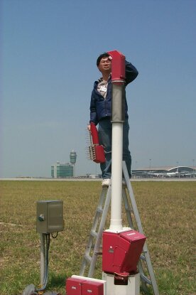
Fig.7 Mr. Ip King Hung cleaning a transmissometer along a runway.
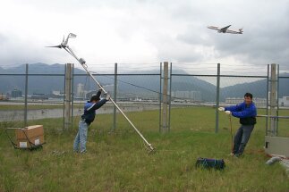
Fig.8 Mr. Ip King Hung and his colleague testing a mast for wind-powered generator.
Imminent Storm
(Photo: Courtesy of Mr. Patrick C.S. Yuen)
Fig.9 Cumulonimbus clouds producing heavy showers on the right (direction of Macau), contrasting the relatively bright sky on the left (Tai O). Visibility dropped below 1000 metres under heavy showers. The weather was associated with the passage of an active cold front. (Photo taken in the afternoon of 25 March 2001).
Hailstorm
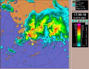
Fig. 10 Radar image at 5:30 p.m., 9 April 2001, severe thunderstorms over Hong Kong. Hail stones as large as 2.5 cm were observed in Tsimshatsui, Kowloon.
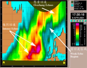
Fig. 11 A vertical cross section along point A and point B revealing signatures of hailstorm.
Terrain-induced Windshear - Typhoon York (1999)
C.W. Wu
The Hong Kong International Airport (HKIA), which is located at Chek Lap Kok (CLK) to the north of Lantau Island, is surrounded by hills. When the airflow is disrupted by the nearby hills, terrain-induced windshear may occur at times around the airport. Under the influence of strong/gale force winds of Typhoon York when it buffeted Hong Kong in 1999, various types of terrain-induced windshear with different magnitudes appeared in the vicinity of CLK. Since nearly all the flights were cancelled due to inclement weather at that time, no windshear reports were available from pilots. However, the impact of windshear on the airport had been nicely picked up by the Terminal Doppler Weather Radar (TDWR).
During the night of 15 September 1999, Typhoon York was centred to the southeast of Hong Kong. Northerly winds prevailed locally. Due to the blockage of the Castle Peak to the north of HKIA, the northerly winds went around Castle Peak and backed slightly to northwest in the downstream region (Fig.12). Castle Peak is located quite a distance from CLK. Since the affected airflow was confined to the waters downstream of Castle Peak, only marginally reaching the approach and departure areas of the north runway, it is believed that the disrupted airflow might have only minimal effect on arriving and departing aircraft.
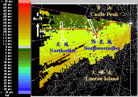
Fig.12 TDWR low-level radial winds observed at 11:20 p.m. 15 September 1999.
As York moved to the south of Lantau Island around noon of 16 September, winds veered to slightly north of east at the HKIA. With the absence of high mountains to the east of CLK, both wind speed and direction as depicted by the radar were comparatively uniform. It is considered that terrain-induced windshear did not occur over the approach and departure corridors.
York swept across the southwestern part of Lantau Island in the afternoon and winds over the HKIA turned southeasterly. At this time, the radar detected some small disturbances downstream of Lantau. These disturbances are believed to be generated as a result of deflection of the airflow by the ridges of Lantau Island, bringing about significant windshear as they moved towards the approach and departure corridors. With the turning of winds at HKIA to southerly, the signature of windshear over the airport became more prominent. Radar radial winds in Fig.13 show that behind the valleys of Lantau Island, several streaks of high-speed airflow were generated over the approach and departure areas. An aircraft flying across this region would have experienced severe windshear reaching 22 m/s, or about 43 kts loss or gain in headwind.
From the above case we can see that when a tropical cyclone affects the HKIA, depending on the wind direction various types of terrain-induced windshear with different magnitudes may result. The study indicates that there is a higher chance for windshear to occur when the background winds come from southeast through southwest, potentially affecting arriving and departing flights.
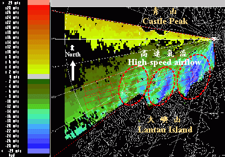
Fig.13 Low-level radial winds observed by the TDWR at 03:59 p.m. 16 September 1999.
Automatic Aircraft Weather Reporting
Y.C. Cheng
With not many weather observations over the South China Sea, aircraft weather reports are an important source of information for the Observatory s weather forecasting. Hitherto, aircraft provide such reports to control tower manually over voice radio. The Observatory receives only about 30 such reports each day.
Now with the emergence of improved air-ground data communication technologies such as Aircraft Communication Addressing and Reporting System (ACARS), Automatic Dependent Surveillance (ADS) and Secondary Surveillance Radar (SSR) Mode S, the opportunity is there for aircraft reporting by fully automatic means. On-board computers can be programmed to prepare and transmit weather reports at regular intervals over digital data channels without the need for pilot intervention nor manual ground handling. The increased volume of aircraft reports is expected to translate into better weather forecasts.
The Hong Kong Observatory is now seeking to use these emerging technologies for the benefit of the aviation community.
Those were the Days
K.K. Lam
The Observatory s long association with aviation began in 1920 when proposal for aviation weather service was first discussed.
Aviation forecasting service began in 1937 when a forecaster was stationed at Kai Tak on a part-time basis. The Airport Meteorological Office (AMO) at the Kai Tak Terminal Building came into operation in 1939. Aviation weather service was once suspended during the Second World War and resumed in August 1947. In response to the rapid growth in civil aviation in post-war years, a team of forecasters manned the AMO full-time starting from 1957 to meet the demand of professional weather services for aviation.
A set of three transmissometers was installed in 1974 along the runway at Kai Tak to measure runway visual range. In 1979, an in-house developed Low-Level Wind Shear Detection System was commissioned aiding the detection of low-level windshear along the precarious flight path over Kowloon City.
With the opening of the new Hong Kong International Airport at Chek Lap Kok in July 1998, new meteorological observation systems were implemented and a new mode of service was introduced to enable the AMO to cope with the ever-increasing demand for aviation weather services. Manual preparation of flight meteorological information documents in the early days had given way to automatic compilation and dissemination by means of web-based technology.
Fig.14 Airport Meteorological Office at Kai Tak.
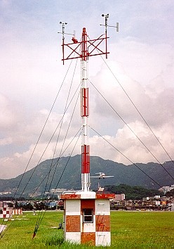
Fig.15 Two sets of anemometer and wind vane at the northwest end of the runway form
part of the Low-level Wind Shear Detection System for the old Kai Tak Airport.
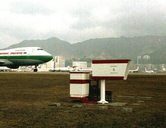
Fig.16 A transmissometer alongside the runway at Kai Tak.
Productivity Achievement Award Scheme
The Hong Kong Observatory receives a Certificate of Appreciation for its web-based Aviation Meteorological Information Dissemination System in serving the aviation community.

Fig.17 Ms Katy Lam of KCRC, member of the judge panel, presenting a Certificate of Appreciation to Mr H.G. Wai on 11 January 2001.
Continuous Learning
By completing more than 5 self-learning packages last year, Mr. David Tse, Chief Experimental Officer and aviation forecaster, received an award under the Learning Recognition Scheme of the Civil Service Training and Development Institute. Our congratulations to David!

Fig.18 Mr. David Tse (3rd from right, middle row) at the award presentation ceremony on 2 April 2001.
The Fifteenth Liaison Meeting with the Airlines
The 15th Meeting of the Liaison Group on Aviation Meteorological Services was held at the Observatory on 28 December 2000. Topics discussed included the Intensive Windshear and Turbulence Reporting Exercises in 2000, experts' review of windshear and turbulence warning service, delivery of meteorological information on broadband circuits, weather services under the Communication Navigation Surveillance / Air Traffic Management (CNS/ATM) Systems and Automated Meteorological Data Relay (AMDAR) observation programme, sea breeze induced windshear and World Area Forecast System (WAFS) transition matters.
Seminar on Aviation Meteorological Information Exchange with CAAC
( 9 -13 January 2001 )
As part of regular technical exchanges, a delegation from Air Traffic Management Bureau, Civil Aviation Administration of China (CAAC/ATMB) visited the Hong Kong Observatory and participated in a seminar on aviation meteorological services and information exchange during 9-13 January 2001. The delegation included representatives from Qingdao, Chengdu, Xi an, Shenyang and Urumqi. They visited the Airport Meteorological Office and the Terminal Doppler Weather Radar Station. The future development of automatic downlink of aircraft weather report was discussed. There was also exchange of ideas on provision of weather data to airlines for flight planning.
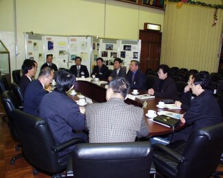
Fig.19 Representatives of CAAC/ATMB and HKO exchanging ideas on aviation weather services in the seminar.
Latest Weather Information at Pilots Fingertips
The Digital Automatic Terminal Information System (D-ATIS) and Digital VOLMET (D-VOLMET) broadcast services officially commenced on 19 April 2001. With appropriate setup on board aircraft, pilots can now get the latest weather information at their fingertips.
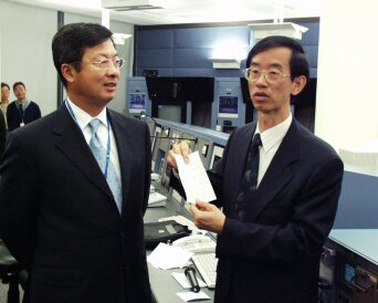
Fig.20 Director-General of Civil Aviation Department, Mr A.K.Y. Lam (left) and Acting Director of the HKO, Mr C.Y. Lam (right) introduce a print-out of air traffic and weather information.
"One of the most professional all-round services that we receive anywhere in the world"- from an airline
The annual survey on aviation weather services conducted in March 2001 gives a satisfactory rating of 98%. We take this opportunity to thank for their returns. They also pointed us to areas requiring further improvement. We shall continue to strive for a better service.
Winning over the Locals
K.K. Yeung
Technical duties aside, station managers of the Observatory' s remote weather stations often face problems beyond their wildest dreams.
Earlier this year, when the Observatory was to install an acoustic sounding system at Sha Lo Wan, there had been concern that the sound beeps from the instrument might cause nuisance to villagers there. Our station mangers, Messrs C.K. Lee and W.M. Leung undertook to interview villagers and understand the situation. To their delight, the villagers hardly noticed any difference when the instrument was switched on. The villagers even thanked them for being so considerate.
Another incident involved a plan to erect fences around the remote weather station at Yi Tung Shan over Lantau, nearby a local resident s house. The resident expressed concern, as the fences might not look good aesthetically in the surrounding pristine area. Messrs. Lee and Leung listened and relayed the message back to the Observatory. The fences were subsequently put on hold. The resident was very pleased with the outcome and offered to look after conditions of our equipment there. To ensure adequate power generation, he even helps clean the solar panels from time to time.
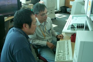
Fig.21 Mr C.K. Lee (left) and Mr W.M. Leung (right) know very well success depends upon a good relationship with people.
|
Telephone and Fax Numbers | |
|
Enquiry on flight documents |
(852) 2910 6922 |
|
|
|
|
|
|
|
|
|
|
|
|
|
| |
|
http://www.weather.gov.hk | |
|
Web Page for Aviation Weather Services | |
|
http://www.weather.gov.hk/aviation | |
|
Editor this issue Paul K.L. Ho | |
Email:mailbox@hko.gov.hk
Hong Kong Observatory : 134A Nathan Road, Kowloon, Hong Kong