Facts about Typhoon Linfa
9 July 2015
Tropical Cyclone Linfa (Linfa) edged towards the coast of Guangdong on 9 July. The Observatory issued the Strong Wind Signal, No. 3 at 8:40am.
Linfa intensified into a Typhoon at 6am on 9 July. In a collaboration between the Observatory and the Government Flying Service, a fixed-wing aircraft undertook meteorological observations in the vicinity of the eye of Linfa. According to the aircraft data obtained, hurricane force winds (118 kilometres per hour or above) were recorded near the eye of Linfa between 7am and 9am, and gale force winds also extended to about 100 kilometres (Figure 1). At that time, Linfa was expected to move west or west-southwest, coming very close to Hong Kong in the evening and posing a threat to Hong Kong. Just before Linfa make landfall near Lufeng, Guangdong Province, its eye structure remained intact (Figure 2). Based on the available meteorological data at that time and out of prime concern for public safety, the Observatory issued the Pre-No.8 Announcement at 2:40pm on 9 July, and then the No.8 Northwest Gale or Storm Signal at 4:40pm.
In the afternoon of 9 July, winds strengthened generally over Hong Kong, with strong winds recorded over many places. Linfa subsequently moved slightly further inland and weakened rapidly over Guangdong. Although Shenzhen, which is just north of Hong Kong, recorded gale force winds in the afternoon, and occasional gales were also recorded on high ground locally, the circulation and area of gales associated with Linfa became significantly smaller. The general occurrence of gale force winds just missed the Hong Kong territory. When the threat of gales had vanished, the Observatory replaced the No. 8 signal by the Strong Wind Signal, No. 3 at 10:10pm.
Limited by the state-of-the-art of science, forecasting the intensity change of tropical cyclones remains a challenge for the meteorological community. The Observatory will endeavor to continuously improve its forecasting techniques.
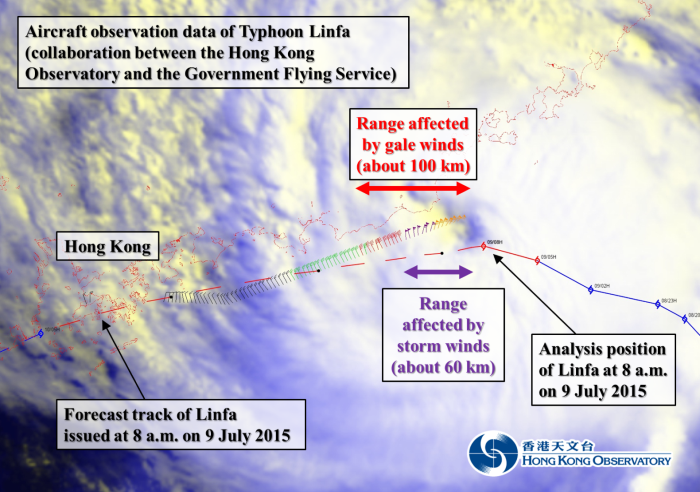
Figure 1: Aircraft observation data collected near Typhoon Linfa (collaboration between the Observatory and the Government Flying Service).
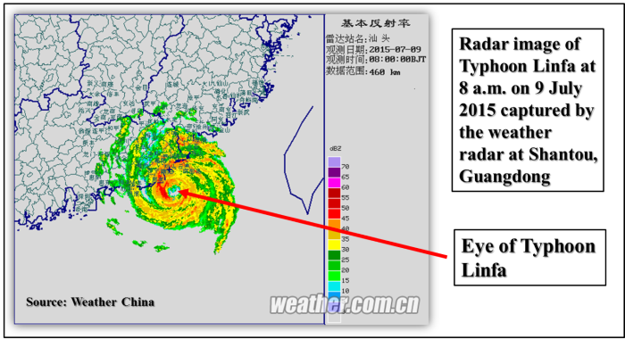
Figure 2: Weather radar image at Shantou, 8 a.m. on 9 July 2015.