Rainstorm on the morning of 22 May 2013
22 May 2013
A trough of low pressure lingering around the coast of Guangdong brought several episodes of heavy rain and thunderstorms to Hong Kong this morning (22 May) which caused landslides and flooding in some places. The Hong Kong Observatory issued the Black Rainstorm Warning Signal at 4:10am, the first time since July 2010.
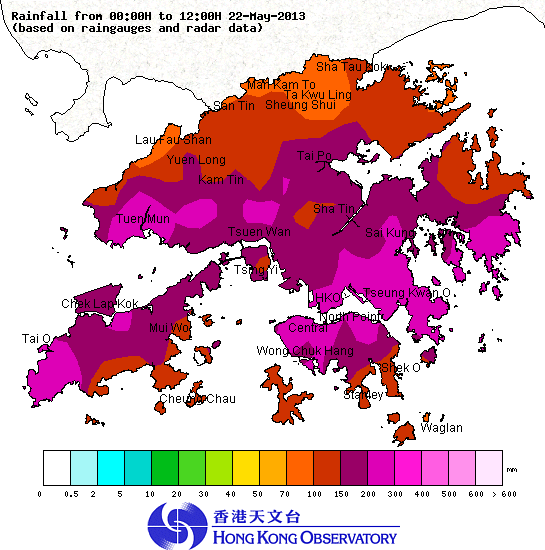
From midnight till noon, more than 150 millimetres of rain were recorded in many places over the territory. The rainfall recorded in Tseung Kwan O, eastern Kowloon, northern part of Hong Kong Island, Tuen Mun and Tung Chung even exceeded 200 millimetres. For the rainfall distribution in Hong Kong today (till noon), please refer to Figure 1.
It is expected that the trough of low pressure will continue to bring rain and thunderstorms to the coastal areas and the northern part of the South China Sea in the next couple of days. For the latest weather forecast, please refer to the following webpages:
http://www.weather.gov.hk/wxinfo/currwx/flw.htm (Local Weather Forecast) and
http://www.weather.gov.hk/wxinfo/currwx/fnd.htm (7-day Weather Forecast).
Up to 5pm, the effective time of the warning signals issued by the Observatory is summarised as follows:-
Thunderstorm Warning:
9pm, 21 May to 2pm, 22 May
3:35 am and is still in force at 5pm, 22 May
Special Announcement on Flooding in the northern New Territories:
3:25am to 10:30am, 22 May
Amber Rainstorm Warning Signal:
1:30am to 3:20am, 22 May
9:45am to 10:30am, 22 May
Red Rainstorm Warning Signal:
3:20 am to 4:10am, 22 May
Black Rainstorm Warning Signal:
4:10am to 9:45am, 22 May
Landslip warning:
5:10am and is still in force at 5pm, 22 May

Figure 1: Rainfall distribution in Hong Kong from midnight to noon on 22 May 2013

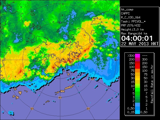
Figure 2: The Hong Kong Observatory's weather radar picture at 4am on 22 May 2013