Reference for the Issue of No.3 and No.8 Signals
Since 2007, the Hong Kong Observatory makes reference to the wind data recorded from a network of eight near-sea level reference anemometers covering the whole of Hong Kong when considering the issuance of Tropical Cyclone Warning Signals, No.3 and No.8. The figure below depicts the network of reference anemometers.
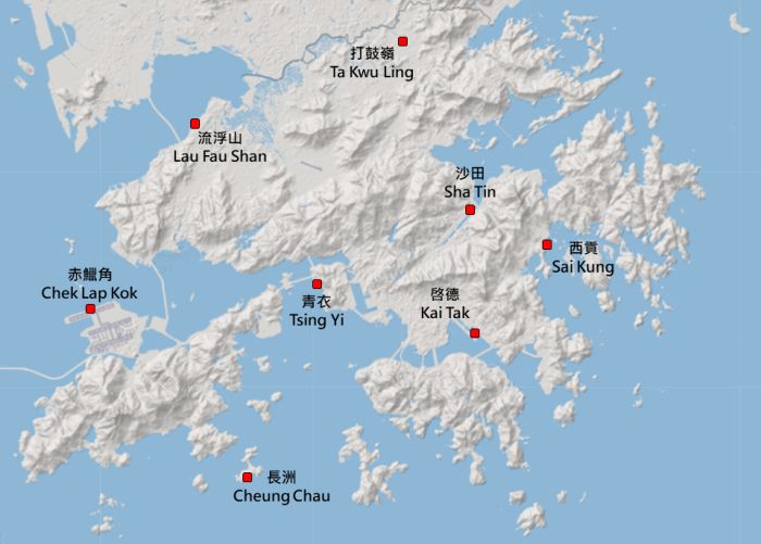
Network of reference anemometers in the tropical cyclone warning system (see Note below)
The reference anemometers were selected on account of their good exposure and geographical distribution, taking into account the natural separation by Hong Kong mountain ranges. Together, they provide a broad picture of the wind condition in Hong Kong.
The No.3 or No.8 signal, as the case may be, will be issued when half or more anemometers in the reference network register or are expected to register sustained winds within prescribed wind speed ranges and the wind condition is expected to persist. The wind speed range of the No.3 signal is 41-62 km/h and that of the No.8 signal is 63-117 km/h.
When a tropical cyclone is located relatively far from Hong Kong, its outer rainband might occasionally sweep across the territory, bringing squalls to Hong Kong and causing transient winds at four or more of the reference anemometers exceeding the prescribed lower thresholds for the issuance of No.3 or No.8 signals. As the wind condition is not expected to persist after the passage of the rainband, the Observatory generally would not issue the respective signal.
[Note: Lau Fau Shan station has replaced the nearby Wetland Park station as a reference anemometer station starting from 2013. The anemometer at Chek Lap Kok has moved from the Centre Runway to the North Runway since 2024.]
 |
 |