Overview of Tropical Cyclone in September 2024
|
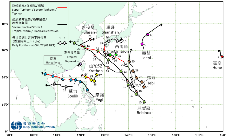
Eleven tropical cyclones occurred over the western North Pacific and the South China Sea in September 2024. Among them, Yagi necessitated the issuance of the first No. 8 Gale or Storm Signal by the Observatory in 2024. Shanshan formed as a tropical depression over the western North Pacific about 940 km south of Iwo Jima on the night of 21 August. It moved generally northwards slowly and gradually intensified in the following two days. Shanshan started to pick up speed, sweeping across the seas south of Iwo Jima on 24 August. Shanshan turned to move northwestwards or west-northwestwards towards the vicinity of the Ryukyu Islands in the small hours of the next day. It intensified into a severe typhoon on the morning of 27 August. Shanshan further intensified into a super typhoon, attaining its peak intensity with an estimated maximum sustained wind of 185 km/h near its centre that night. It gradually turned to move northwards towards Kyushu, Japan. Shanshan moved slowly across the vicinity of Kyushu, Japan and weakened gradually on 29 August. It then turned to move generally eastwards across Shikoku and the coastal areas in southern Honshu, Japan in the following two days. It finally degenerated into an area of low pressure over the coastal waters south of Honshu, Japan on the afternoon of 1 September. According to press reports, Shanshan brought torrential rain and squalls to many places in Japan. A 72-hour rainfall of 821 millimetres was recorded in Misato of Miyazaki Prefecture, Kyushu, and there were reports of a possible tornado in Miyazaki Prefecture. Shanshan caused 8 deaths and 133 injuries in Japan. More than 1 300 houses were damaged. Water and electricity supply to more than 2 100 and 280 000 households were disrupted respectively. Land and air transport were severely affected, with over 2 000 flights cancelled. Yagi formed as a tropical depression over the seas east of the central part of the Philippines about 560 km east-southeast of Manila on the morning of 1 September. It moved northwestwards towards Luzon and intensified into a tropical storm that night. Yagi moved across Luzon the next day and entered the northern part of the South China Sea on 3 September. Yagi then tracked generally westwards across the northern part of the South China Sea. Under the favourable conditions of very warm sea water and weak vertical wind shear, Yagi rapidly intensified into a super typhoon from a severe tropical storm on 4 September. Yagi attained its peak intensity with an estimated maximum sustained wind of 230 km/h near its centre in the small hours on 6 September, making it the second strongest tropical cyclone in the South China Sea since the Observatory’s records began in 1950, on par with Super Typhoon Saola in 2023. Yagi turned to move west-northwestwards towards Hainan Island that morning and made landfall near Wenchang, Hainan Island that evening. Yagi continued to maintain super typhoon intensity while moving across Beibu Wan the next day, and made landfall near the northern part of Vietnam in the afternoon. It then moved into inland areas of the northern part of Vietnam and weakened rapidly. Yagi finally degenerated into an area of low pressure on the night of 8 September. According to press reports, Yagi left 21 deaths, 26 missing and 22 injuries in the Philippines during its passage. More than 3 million people were affected, over 7 000 houses were damaged and economic loss exceeded PHP 2.6 billion. In Guangdong, Guangxi and Hainan, more than 2.7 million people were affected and over 450 000 people were evacuated. Yagi left 4 deaths and 95 injuries in Hainan. More than 32 000 houses were damaged, the number of fallen trees amounted to over 160 000, and economic loss exceeded RMB 78.6 billion. Yagi and its remnant brought torrential rain to Vietnam, Lao PDR, Thailand and Myanmar, triggering landslides and flooding in many places. In Vietnam, there were at least 323 deaths, 22 missing and 1 978 injuries. More than 3.6 million people were affected, over 280 000 houses were damaged, and economic loss exceeded VND 81 trillion. In Lao PDR, there were at least 7 deaths and more than 180 000 people affected. Economic loss exceeded USD 7.9 million. In Thailand, there were at least 52 deaths and 28 injuries. In Myanmar, there were at least 360 deaths, 100 missing and 48 injuries. More than 1.1 million people were affected and over 140 000 houses were damaged. For detailed information of Yagi including its impact to Hong Kong, please refer to the Tropical Cyclone Report of Yagi. Originating from the central North Pacific, Hone moved across the International Date Line with tropical depression intensity and entered the western North Pacific on the morning of 3 September. At the time, the maximum sustained wind near its centre was estimated to be 45 km/h and it tracked north-northwestwards. Hone finally degenerated into an area of low pressure over sea on the morning of 4 September. Leepi formed as a tropical depression over the western North Pacific about 800 km northeast of Iwo Jima on the night of 4 September, and moved generally northwards towards the seas east of Japan. It intensified into a tropical storm, attaining its peak intensity with an estimated maximum sustained wind of 65 km/h near its centre on the afternoon of 5 September. Leepi then turned to move northeastwards, and finally evolved into an extratropical cyclone over the western North Pacific to the east of Japan on the morning of 7 September. Bebinca formed as a tropical depression over the western North Pacific about 360 km southeast of Guam on the morning of 10 September. It moved generally northwestwards towards the vicinity of the Ryukyu Islands and intensified gradually in the following three days. Bebinca moved across the vicinity of the Ryukyu Islands on 14 September, and turned to move west-northwestwards towards the vicinity of the Yangtze River Estuary. Besides, it intensified into a typhoon in the small hours of 15 September, and attained its peak intensity with an estimated maximum sustained wind of 145 km/h near its centre that afternoon. Maintaining its peak intensity, Bebinca made landfall over Pudong of Shanghai on the morning of 16 September. According to the China Meteorological Administration, Bebinca was the strongest tropical cyclone to hit Shanghai since records bagan in 1949. It then moved inland and weakened rapidly. Bebinca finally degenerated into an area of low pressure over Henan in the small hours of 18 September. According to press reports, Bebinca and its remnant brought torrential rain and squalls to Shanghai, Zhejiang, Jiangsu, Anhui, Henan and Shandong. There were four deaths, more than 1.3 million people affected and over one million people evacuated. More than 50 000 hectares of crops were damaged and economic loss exceeded RMB 550 billion. Air and marine transport were affected. A total of 918 flights were cancelled at Shanghai Pudong International Airport and Hongqiao International Airport. 153 passenger ferry routes at coastal ports in Zhejiang were suspended. Pulasan formed as a tropical depression over the western North Pacific about 1 360 km south-southeast of Iwo Jima on the night of 15 September. It tracked generally northwestwards towards the vicinity of the Ryukyu Islands and intensified gradually. Pulasan intensified into a tropical storm on the morning of 17 September, and attained its peak intensity with an estimated maximum sustained wind of 85 km/h near its centre that night. It moved across the vicinity of the Ryukyu Islands and the East China Sea towards Zhejiang in the following two days. Pulasan made landfall over Zhoushan of Zhejiang and Fengxian of Shanghai successively on the night of 19 September, making it the second tropical cyclone making landfall over the Yangtze River Delta region within four days, following Bebinca. It then weakened gradually, and turned to move northeastwards or east-northeastwards into the Yellow Sea the next day. Pulasan finally evolved into an extratropical cyclone near the southwest coast of the Korean Peninsula on the afternoon of 21 September. According to press reports, Pulasan brought torrential rain to Zhejiang, Shanghai, Jiangxi, Fujian, Jiangsu and other places. More than 350 000 people were affected and more than 330 000 people were evacuated. In Shanghai, more than 5 400 hectares of crops were damaged, with economic loss exceeding RMB 30 million. Marine, land and air transport in Shanghai were also affected, with 51 flights cancelled, 54 railway trains and 26 ferry routes suspended. There were reports of tornado in Qingpu of Shanghai. Pulasan and the extratropical cyclone it evolved into also brought torrential rain to the Republic of Korea and Japan, triggering severe flooding and landslides in many places. Record-breaking rainfall was recorded in many places in the southern part of the Republic of Korea. Among them, Changwon of South Gyeongsang recorded one-hour rainfall of 104.9 millimetres and 24-hour rainfall of 397.7 millimetres on 21 September. More than 1 500 people were evacuated in the Republic of Korea. Over 190 houses and more than 4 100 hectares of crops were damaged. In Japan, there were 16 deaths and 47 injuries. More than 530 houses were damaged. Water and electricity supply to at least 5 200 and 6 900 households were disrupted respectively. Soulik formed as a tropical depression over the central part of the South China Sea about 470 km east of Xisha on the afternoon of 17 September. It tracked generally westwards towards the central part of Vietnam. Soulik intensified into a tropical storm, attaining its peak intensity with an estimated maximum sustained wind of 65 km/h in the small hours of 19 September. It made landfall over the central part of Vietnam that afternoon, and finally degenerated into an area of low pressure in Lao PDR on the morning of 20 September. According to press reports, Soulik, together with the southwest monsoon, brought torrential rain to the western part of the Philippines. Around 9 000 people were affected and 2 000 people were evacuated. After the passage of Yagi in early September, Soulik and its remnant brought heavy rain to Vietnam, Lao PDR, Thailand and Myanmar again. In Vietnam, there were at least two deaths, one injury, and more than 90 houses damaged. In Thailand, there were at least five deaths, and over 8 000 hectares of crops damaged. In Myanmar, there were more than 300 deaths, 100 injuries and over 800 000 people affected. A tropical depression formed over the Taiwan Strait about 180 km east-northeast of Xiamen on the morning on 22 September, with an estimated maximum sustained wind of 55 km/h near its centre. It moved west-southwestwards edging closer to the coast of Fujian, and finally degenerated into an area of low pressure over the coastal waters of Fujian that night. Cimaron formed as a tropical depression over the western North Pacific about 610 km southeast of Kagoshima. It tracked generally westwards across the seas south of Japan and intensified gradually. Cimaron intensified into a tropical storm, attaining its peak intensity with an estimated maximum sustained wind of 65 km/h that night. It weakened gradually on 26 September, and finally degenerated into an area of low pressure over the seas south of Japan that night. Jebi formed as a tropical depression over the western North Pacific about 1 080 km south-southeast of Iwo Jima on the morning of 26 September and moved generally north-northwestwards towards the seas south of Iwo Jima. It intensified into a tropical storm on the afternoon of the next day. Jebi moved across the vicinity of Iwo Jima and gradually turned to move north-northeastwards towards the seas east of Japan on 29 – 30 September. Krathon formed as a tropical depression over the western North Pacific about 600 km south of Okinawa on the morning of 27 September and moved southwestwards at first. It lingered over the seas east of the Luzon Strait and intensified gradually the next day. Krathon began to pick up speed to track west-northwestwards, and rapidly intensified into a severe typhoon from a severe tropical storm on 29 September. It further intensified into a super typhoon in the small hours of 30 September, and then moved across the Luzon Strait. |
Provisional Tropical Cyclone Tracks in September 2024