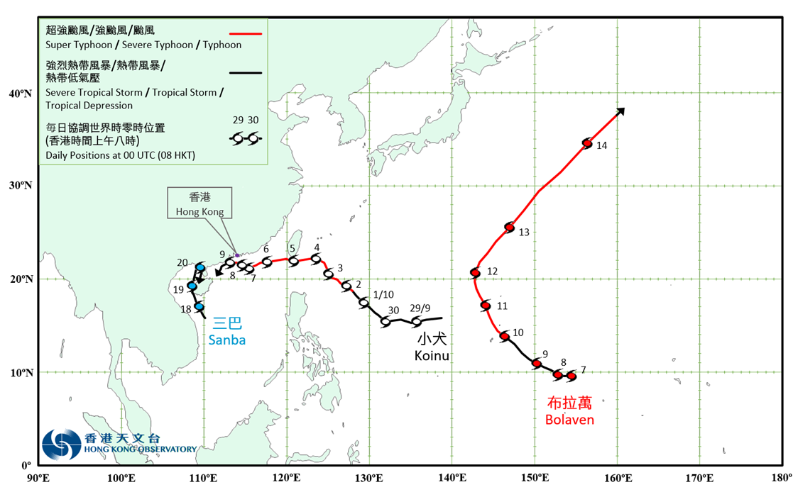
Overview of Tropical Cyclone in October 2023
|
Three tropical cyclones occurred over the western North Pacific and the South China Sea in October 2023. Among them, Koinu necessitated the issuance of the tropical cyclone warning signals by the Observatory. Koinu formed as a tropical depression over the western North Pacific about 1 920 km east of Manila on the night of 28 September. It then moved westwards and intensified gradually. It turned to move northwestwards across the seas east of the Philippines on the afternoon of 30 September and in the following three days. During this period, Koinu intensified into a severe typhoon on the afternoon of 2 October and attained its peak intensity with an estimated maximum sustained wind of 175 km/h near its centre that night. Koinu tracked westwards towards the vicinity of the southern part of Taiwan on 4 October. After moving across the southern part of Taiwan the next day, Koinu weakened into a typhoon and then moved west-southwestwards across the northern part of the South China Sea. Koinu intensified into a severe typhoon again on the night of 6 October and turned gradually to move west-northwestwards, edging slowly towards the coast of Guangdong. It further moved slowly towards the vicinity of the Pearl River Estuary with severe typhoon to typhoon intensity in the following two days. However, under the influence of the northeast monsoon, Koinu weakened rapidly and turned gradually to move southwestwards on 9 October. Finally, it degenerated progressively into an area of low pressure over the coastal waters of Yangjiang that night. According to press reports, one person was killed and 399 people were injured when Koinu affected Taiwan. Water and electricity supply to more than 6 000 and 460 000 households were disrupted respectively. Around 3 000 people were displaced. Economic loss exceeded USD 18 million. In Macao, two people were injured during the passage of Koinu. There were also 13 incident reports, including fallen trees and landslides. For detailed information of Koinu including its impact to Hong Kong, please refer to the Tropical Cyclone Report of Koinu. Bolaven formed as a tropical depression over the western North Pacific about 1 140 km east-southeast of Guam on the morning of 7 October. It moved slowly westwards at first. It tracked west-northwestwards or northwestwards towards the vicinity of Iwo Jima and intensified gradually in the following three days. Bolaven intensified into a super typhoon on the morning of 11 October and attained its peak intensity with an estimated maximum sustained wind of 250 km/h near its centre that night. Bolaven gradually turned to move northeastwards the next day and weakened in the following two days. Finally, it evolved into an extratropical cyclone over the western North Pacific on the night of 14 October. Sanba formed as a tropical depression over the central part of the South China Sea about 220 km east of Da Nang on the afternoon of 17 October. It moved north-northwestwards towards the vicinity of Beibu Wan and intensified gradually. Sanba intensified into a tropical storm the next morning and attained its peak intensity with an estimated maximum sustained wind of 85 km/h near its centre on the night of 19 October. Sanba lingered over the vicinity of Beibu Wan and skirted past Leizhou Peninsula on 20 October. Finally, it degenerated into an area of low pressure over Beibu Wan that night. According to press reports, under the influence of the torrential rain associated with Sanba and its remnant, there were severe flooding over many places in Guangdong, Guangxi and Hainan provinces during 17 – 21 October. Record-breaking rainfall was recorded at many meteorological stations. Among them, Beihai, Guangxi recorded a 24-hour rainfall of 780.3 millimetres, breaking respective record since meteorological records began in Guangxi. At least four people were killed or missing and more than 2.13 million people were affected in Guangdong, Guangxi and Hainan provinces during the passage of Sanba. |

Provisional Tropical Cyclone Tracks in October 2023