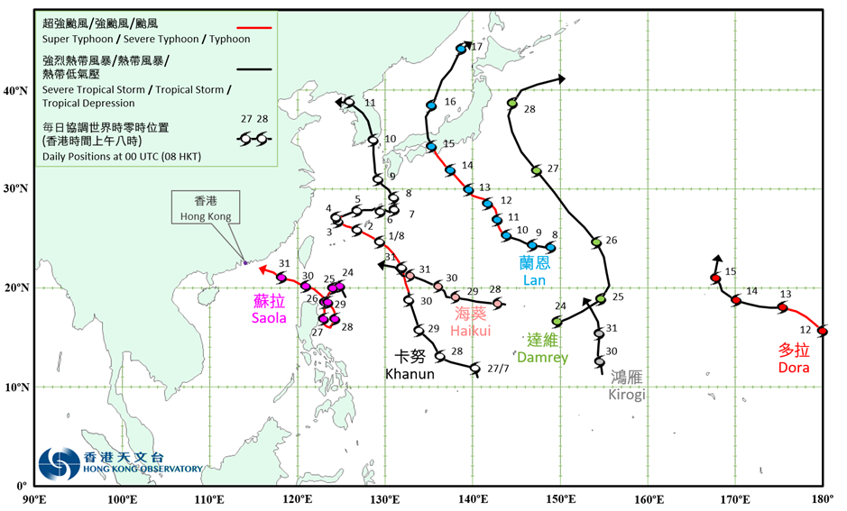
Overview of Tropical Cyclone in August 2023
|
Seven tropical cyclones occurred over the western North Pacific and the South China Sea in August 2023. Among them, Saola and Haikui necessitated the issuance of the tropical cyclone warning signals by the Observatory. Khanun formed as a tropical depression over the western North Pacific about 2 170 km southeast of Okinawa in the small hours on 27 July. It moved northwestwards or north-northwestwards towards the vicinity of the Ryukyu Islands and intensified gradually in the following four days. Khanun intensified into a super typhoon on the night of 31 July, and reached its peak intensity with an estimated sustained wind of 195 km/h near the centre the next morning. It then tracked west-northwestwards and weakened gradually. Khanun turned to move eastwards across the vicinity of the Ryukyu Islands from the afternoon of 3 August to 6 August. Khanun turned to move north-northwestwards again across the East China Sea in the following four days, and finally degenerated into an area of low pressure over the Korean Peninsula on the afternoon of 11 August. According to press reports, Khanun brought very heavy rain and squalls to Japan. Parts of the southern Kyushu recorded cumulative rainfall of more than 1 000 millimeters, causing 1 death and 97 injuries. More than 210 houses were damaged. Water and electricity supply to more than 30 000 and 240 000 households were disrupted respectively. Economic loss exceeded 2 billion JPY. Khanun left 2 deaths in the Republic of Korea during its passage. There were also about 360 reports of damaged facilities. More than 15 000 people were evacuated. Economic loss exceeded 56 billion KRW. Lan formed as a tropical depression over the western North Pacific about 790 km east of Iwo Jima in the small hours on 8 August. It then moved west-northwestwards and intensified gradually. Lan turned to move northwestwards or north-northwestwards towards Honshu, Japan. Lan intensified into a severe typhoon the next day, and reached its peak intensity with an estimated sustained wind of 175 km/h near the centre in the morning. Lan weakened into a typhoon on the night of 12 August and continued to edge closer to Honshu, Japan in the following two days. Lan moved across Honshu, Japan on 15 August and finally evolved into an extratropical cyclone over the Sea of Japan on the afternoon of 17 August. According to press reports, Lan left more than 50 injures in Japan during its passage. 130 houses were damaged. Water and electricity supply to more than 7 000 and 100 000 households were disrupted respectively. Originating from the eastern North Pacific, Dora moved across the International Date Line with severe typhoon intensity and entered the western North Pacific on the morning of 12 August. The maximum sustained wind near its centre was estimated to be 165 km/h at the time. It tracked northwestwards or west-northwestwards towards the vicinity of Wake Island. Dora weakened gradually in the following three days and finally degenerated into an area of low pressure over sea on the morning of 16 August. Saola formed as a tropical depression over the western North Pacific about 670 km southeast of Gaoxiong on the night of 23 August and moved slowly at first. It then made an anti-clockwise loop over the seas east of Luzon and intensified rapidly in the following five days. Saola intensified into a super typhoon on the night of 26 August. Saola weakened from a super typhoon into a severe typhoon twice in the following three days, but intensified into a super typhoon again on the evening of 29 August and tracked west-northwestwards across the Luzon Strait. Saola entered the South China Sea later on 30 August. It edged closer to the coast of Guangdong gradually while maintaining super typhoon intensity the next day. Damrey formed as a tropical depression over the western North Pacific about 1 260 km southeast of Iwo Jima on the night of 23 August and moved slowly at first. It started to pick up speed to track east-northeastwards and intensified gradually the next day. It turned to move northwestwards towards the seas east of Honshu of Japan in the following two days. Damrey intensified into a severe tropical storm on the afternoon of 26 August, and reached its peak intensity with an estimated sustained wind of 110 km/h near the centre the next night. Damrey then gradually turned to move northeastwards and finally evolved into an extratropical cyclone over the seas east of Japan on the morning of 29 August. Haikui formed as a tropical depression over the western North Pacific about 760 km south-southeast of Iwo Jima on the night of 27 August. It moved westwards or west-northwestwards towards the southern part of Taiwan and intensified gradually in the following four days. Kirogi formed as a tropical depression over the western North Pacific about 1 110 km east of Guam in the small hours on 30 August. It moved northwards and intensified gradually. Kirogi intensified into a severe tropical storm and turned to move north-northwestwards the next afternoon. |

Provisional Tropical Cyclone Tracks in August 2023