Overview of Tropical Cyclone in November 2022
|
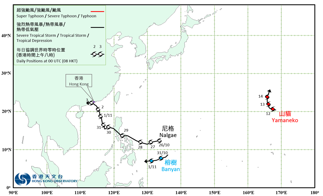
Three tropical cyclones occurred over the western North Pacific and the South China Sea in November 2022. Among them, Nalgae necessitated the issuance of the No. 8 tropical cyclone warning signal by the Hong Kong Observatory, which was the third tropical cyclone requiring the issuance of the No. 8 Signal in November since records began in 1946. Nalgae formed as a tropical depression over the western North Pacific about 1 390 km east of Manila on the morning of 26 October. It moved generally west-northwestwards towards the Philippines and intensified gradually. Nalgae intensified into a severe tropical storm in the small hours on 29 October and moved across the Philippines. It weakened into a tropical storm next day and entered the central part of the South China Sea. Nalgae turned to move north-northwestwards that night and intensified gradually again. Nalgae re-intensified into a severe tropical storm on the afternoon of 31 October and attained its peak intensity with an estimated maximum sustained wind of 110 km/h near its centre. Nalgae continued to edge closer to coast of Guangdong on 2 November. However, it weakened into a tropical storm in the afternoon due to the influence of the northeast monsoon. Nalgae skirted past the waters south of Hong Kong that night and made landfall over Zhuhai the next morning. It degenerated into an area of low pressure over the western part of Guangdong afterwards. According to press reports, the passage of Nalgae left 155 deaths, 129 injuries and 34 missing in the Philippines. Over 2 million people were affected and economic loss exceeded 120 million USD. For detailed information of Nalgae including its impact to Hong Kong, please refer to the Tropical Cyclone Report of Nalgae. Banyan formed as a tropical depression over the western North Pacific about 240 km west-southwest of Yap on the night of 30 October and tracked west-southwestwards. Banyan intensified into a tropical storm the next morning, reaching its peak intensity with an estimated maximum sustained wind of 65 km/h near its centre. It weakened afterwards and finally degenerated into an area of low pressure over the western North Pacific to the east of the Philippines on 1 November. Yamaneko formed as a tropical depression over the western North Pacific about 210 km northeast of Wake Island in the small hours on 12 November and moved west-northwestwards. It reached its peak intensity that morning with an estimated maximum sustained wind of 55 km/h near its centre. Yamaneko gradually turned to move northwards at night and finally degenerated into an area of low pressure over the western North Pacific to the north of Wake Island on 14 November. |

Provisional Tropical Cyclone Tracks in November 2022