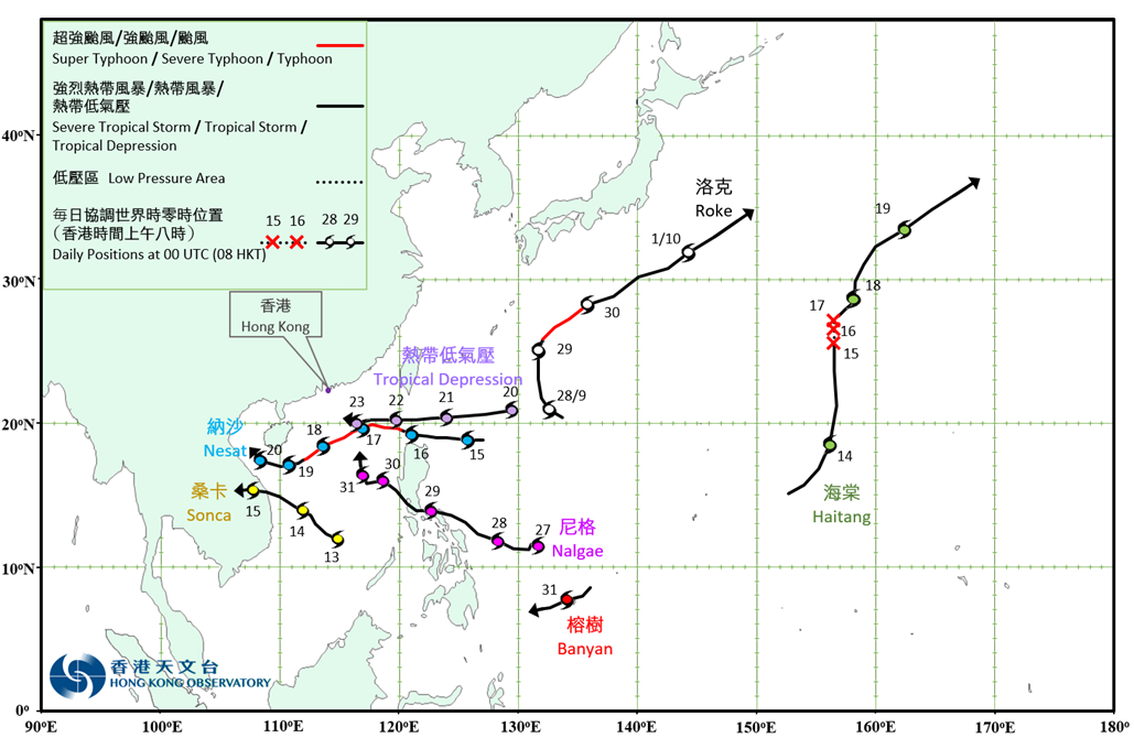
Overview of Tropical Cyclone in October 2022
|
Seven tropical cyclones occurred over the western North Pacific and the South China Sea in October 2022. Among them, Nesat and Nalgae necessitated the issuance of the tropical cyclone warning signals by the Observatory. Roke formed as a tropical depression over the western North Pacific about 890 km southeast of Okinawa in the small hours on 28 September and moved northwestwards at first. It then turned to move northwards that afternoon and intensified rapidly. Roke intensified into a typhoon on the afternoon of 29 September and turned to move northeastwards. It reached its peak intensity that night with an estimated maximum sustained wind of 140 km/h near its centre. Roke weakened gradually afterwards and finally evolved into an extratropical cyclone over the western North Pacific to the east of Japan on 1 October. Sonca formed as a tropical depression over the southern part of the South China Sea about 860 km east-southeast of Danang on the morning of 13 October. It moved generally northwestwards towards the central part of Vietnam and intensified gradually. Sonca intensified into a tropical storm on the afternoon of the next day and reached its peak intensity with an estimated maximum sustained wind of 65 km/h near its centre. It weakened gradually afterwards. Sonca finally dissipated inland after making landfall over the central part of Vietnam on 15 October. According to press reports, Sonca brought torrential rain and squalls to Vietnam, leaving 10 deaths with economic loss of around US$61 million. Nesat formed as a tropical depression over the western North Pacific about 800 km northeast of Manila in the small hours on 15 October. It moved westwards towards Luzon Strait and intensified gradually. Nesat entered the northern part of the South China Sea and intensified into a typhoon on the afternoon of the next day. It turned to move west-southwestwards towards the vicinity of Xisha on 17 October. Nesat reached its peak intensity that night with an estimated maximum sustained wind of 145 km/h near its centre. Under the influence of the northeast monsoon, it weakened gradually in the following three days and finally degenerated into an area of low pressure over the central part of the South China Sea to the southwest of Hainan Island on 20 October. For detailed information of Nesat including its impact to Hong Kong, please refer to the Tropical Cyclone Report of Nesat. Haitang formed as a tropical depression over the western North Pacific about 870 km east-northeast of Guam on the afternoon of 13 October. It moved northeastwards at first and tracked northwards gradually the next day. Haitang weakened into an area of low pressure in the small hours on 15 October and its remnant continued to track northwards in the following 2 days. The low pressure area associated with the remnant of Haitang re-intensified into a tropical depression on the afternoon of 17 October. Haitang moved generally northeastwards and intensified gradually. It intensified into a tropical storm in the small hours on 18 October, reaching its peak intensity with an estimated maximum sustained wind of 65 km/h. Haitang evolved into an extratropical cyclone over the western North Pacific the next day. A tropical depression formed over the western North Pacific about 1 140 km northeast of Manila on the morning of 20 October and moved westwards. The tropical depression reached its peak intensity on the afternoon of 21 October with an estimated maximum sustained wind of 55 km/h near its centre. It skirted past Luzon Strait and entered the northern part of the South China Sea the next day. The tropical depression finally degenerated into an area of low pressure over the northern part of the South China Sea to the south of Dongsha on 23 October. Nalgae formed as a tropical depression over the western North Pacific about 1 210 km east-southeast of Manila on the morning of 27 October and intensified progressively into a tropical storm that afternoon. It turned to move west-northwestwards towards Luzon in the next day. Nalgae intensified into a severe tropical storm and moved across the southern part of Luzon on 29 October. It slowed down after entering the central part of the South China Sea on 30 October. It turned to move north-northwestwards afterwards. Banyan formed as a tropical depression over the western North Pacific about 240 km west-southwest of Yap on the night of 30 October and tracked west-southwestwards. Banyan intensified into a tropical storm on the morning of the next day. |

Provisional Tropical Cyclone Tracks in October 2022