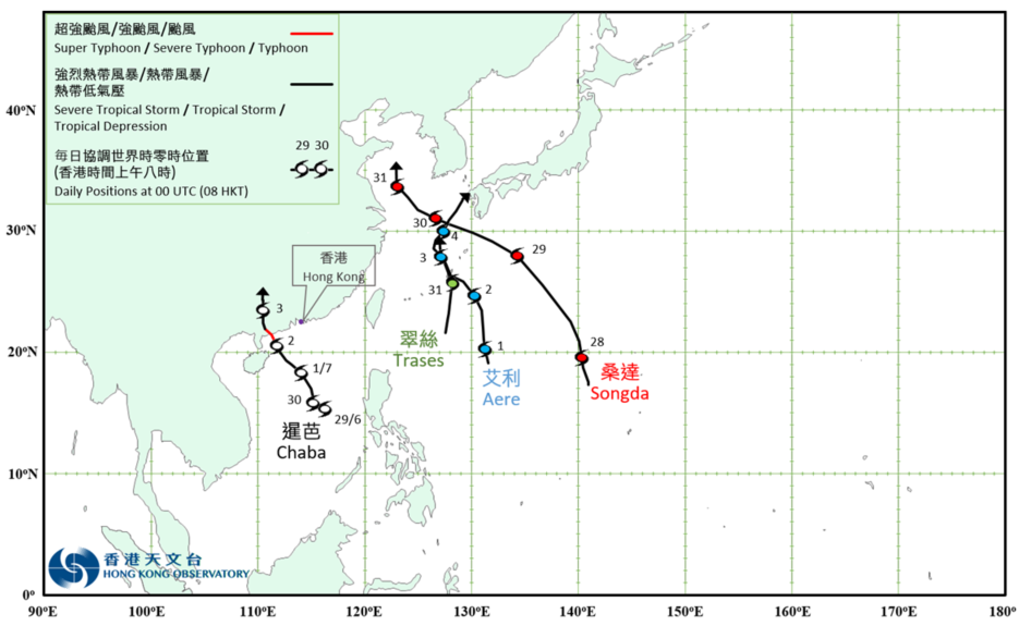
Overview of Tropical Cyclone in July 2022
|
Four tropical cyclones occurred over the western North Pacific and the South China Sea in July 2022. The No. 8 Gale or Storm Signal was issued the first time in this year during the passage of Chaba. Chaba developed into a tropical depression over the central part of the South China Sea about 460 km east-southeast of Xisha on the morning of 29 June. It moved slowly west-northwestwards on that day and intensified gradually. Chaba developed into a tropical storm the next day and moved generally north-northwestwards towards the coast of western Guangdong. It further intensified into a typhoon on the morning of 2 July, reaching its peak intensity with an estimated maximum sustained wind of 120 km/h near its centre. Chaba made landfall near Maoming later in that afternoon. It then moved inland and weakened afterwards. Chaba finally degenerated into an area of low pressure over inland Guangxi on the night of 3 July. According to press reports, Chaba brought torrential rain and squalls to Guangdong and there were flooding over many places. Power supply to over 230 000 households in Maoming was suspended. Chaba also triggered quite a number of tornados in Guangdong, resulting in a large number of building damages. Under inclement weather, a construction vessel sank over the seas about 160 miles southwest of Hong Kong. 12 crew members were killed and 14 others were reported missing. For detailed information of Chaba including its impact to Hong Kong, please refer to the Tropical Cyclone Report of Chaba. Aere formed as a tropical depression over the western North Pacific about 890 km south-southeast of Okinawa on the night of 30 June. It moved northwards towards the vicinity of the Ryukyu Islands and intensified gradually. Aere intensified into a tropical storm the next morning and reached its peak intensity with an estimated maximum sustained wind of 75 km/h near its centre in the afternoon. Aere turned to move northwestwards skirting past the vicinity of Ryukyu Islands on 2 July and weakened gradually. It finally degenerated into an area of low pressure over Kyushu, Japan on 5 July. Songda formed as a tropical depression over the western North Pacific about 830 km south of Iwo Jima on the afternoon of 27 July. It moved north-northwestwards and intensified gradually. Songda developed into a tropical storm on the night of 28 July and reached its peak intensity with an estimated maximum sustained wind of 65 km/h near its centre. It moved rapidly west-northwestwards in the following two days and weakened. Songda finally degenerated into an area of low pressure over the Yellow Sea on the night of 31 July. Trases formed as a tropical depression over the western North Pacific about 510 km south of Okinawa on the afternoon of 30 July. It moved northwards towards the vicinity of the Ryukyu Islands and intensified gradually. Trases intensified into a tropical storm on the morning of 31 July and moved across the East China Sea. |

Provisional Tropical Cyclone Tracks in July 2022