Overview of Tropical Cyclone in October 2021
|
Six tropical cyclones occurred over the western North Pacific and the South China Sea in October 2021. Among them, Lionrock and Kompasu necessitated the issuance of the tropical cyclone warning signals by the Observatory. Mindulle formed as a tropical depression over the western North Pacific about 290 km southeast of Guam on the morning of 23 September. It moved west-northwestwards and intensified gradually. Mindulle developed into a severe tropical storm on the night of 24 September. It turned to move northwestwards and intensified rapidly. Mindulle further developed into a super typhoon on 26 September and reached its peak intensity with an estimated maximum sustained wind of 220 km/h near its centre. It tracked northwards in the following three days and turned to move northeastwards towards the seas east of Japan on 30 September. Mindulle finally evolved into an extratropical cyclone over the seas east of Japan on 1 October. A monsoon depression developed into a tropical depression over the central part of the South China Sea about 290 km east-southeast of Sanya on the afternoon of 7 October. It generally tracked northwestwards towards Hainan Island. The tropical depression was named Lionrock on the morning of 8 October and intensified into a tropical storm. Lionrock reached its peak intensity in the afternoon with an estimated maximum sustained wind of 75 km/h near its centre. When Lionrock moved across Hainan Island on 9 October, it took on an erratic track and made an anti-clockwise loop. Lionrock turned to move west-northwestwards in that afternoon and entered Beibu Wan at night. It degenerated into an area of low pressure over the coast of northern Vietnam on the night of 10 October. According to press reports, Lionrock left six injuries in Macao. Besides, it also brought torrential rain to Zhuhai and triggered extensive flooding. For detailed information of Lionrock including its impact to Hong Kong, please refer to the Tropical Cyclone Report of Lionrock. Kompasu developed as a tropical depression over the western North Pacific about 1 020 km east of Manila on the night of 8 October. It moved northwards at first and intensified gradually. Kompasu picked up speed to move westwards on 10 October. It developed into a severe tropical storm and moved across the Luzon Strait on 11 October. Kompasu moved westwards across the northern part of the South China Sea on 12 October. It further developed into a typhoon on the morning of next day, reaching its peak intensity with an estimated sustained wind of 120 km/h near its centre. Kompasu moved across Hainan Island on 13 October and weakened rapidly. It degenerated into an area of low pressure over Beibu Wan on 14 October. According to press reports, Kompasu left 40 deaths, 5 injuries, 17 missing and over 500 000 people evacuated in the Philippines during its passage. Besides, the Yantian Port in Guangdong and 3 ports in Hainan Island were closed and the marine transportation services were suspended because of the torrential rain brought by Kompasu. For detailed information of Kompasu including its impact to Hong Kong, please refer to the Tropical Cyclone Report of Kompasu . Namtheun formed as a tropical depression over the western North Pacific about 550 km west-southwest of Wake Island on the night of 9 October. It moved west-northwestwards and intensified gradually. Namtheun turned to move northwards on 12 October and drifted northeastwards the next day. Namtheun intensified into a severe tropical storm and reached its peak intensity on the morning of 16 October with an estimated maximum sustained wind of 90 km/h near its centre. It then weakened rapidly and finally evolved into an extratropical cyclone over the western North Pacific to the north of Wake Island on 17 October. Malou formed as a tropical depression over the western North Pacific about 340 km northeast of Yap Island on the morning of 24 October. It generally moved northwards and intensified gradually. Malou intensified into a typhoon on the night of 27 October and turned to move north-northeastwards. It reached its peak intensity on the afternoon of 28 October with an estimated maximum sustained wind of 145 km/h near its centre. Malou then weakened gradually and finally evolved into an extratropical cyclone over the seas east of Japan on 29 October. A tropical depression formed over the southern part of the South China Sea about 280 km east of Nansha on the afternoon of 24 October. It generally moved westwards or northwestwards. The tropical depression reached its peak intensity on the afternoon of 26 October with an estimated maximum sustained wind of 55 km/h near its centre. It degenerated into an area of low pressure over the southern part of Vietnam on 27 October. |
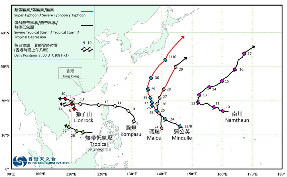
Provisional Tropical Cyclone Tracks in October 2021