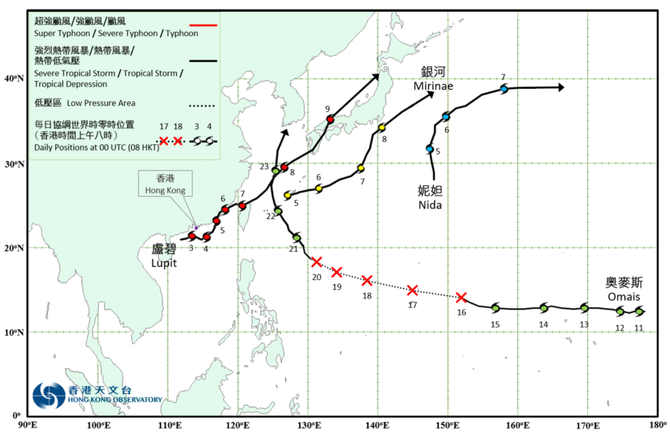
Overview of Tropical Cyclone in August 2021
|
Four tropical cyclones occurred over the western North Pacific and the South China Sea in August 2021. Lupit necessitated the issuance of the tropical cyclone warning signals by the Observatory. Lupit formed as a tropical depression over the northern part of the South China Sea at about 280 km southwest of Hong Kong on the night of 2 August. It moved generally east-northeastwards across the northern part of the South China Sea and intensified gradually. Lupit slowed down on the morning of 3 August and turned to move southeastwards in the afternoon. It then turned to move northeastwards in the small hours on 4 August and intensified into a tropical storm in the morning. Lupit reached its peak intensity in the small hours on 5 August with an estimated maximum sustained wind of 85 km/h near its centre. It skirted past the coastal areas of Fujian in the afternoon and the next day, and weakened into a tropical depression. Lupit re-intensified into a tropical storm over the Taiwan Strait in the small hours on 7 August and tracked northeastwards towards Japan. It finally evolved into an extratropical cyclone over the seas north of Honshu of Japan on 9 August. According to press reports, Lupit brought torrential rain and flooding to Kyushu of Japan and Taiwan. For detailed information of Lupit including its impact to Hong Kong, please refer to the Tropical Cyclone Report of Lupit. Nida formed as a tropical depression over the western North Pacific about 760 km east-northeast of Iwo Jima on the afternoon of 4 August. It tracked northwards and intensified gradually. Nida intensified into a tropical storm on 5 August and turned to move east to northeastwards across the western North Pacific east of Japan the next day. Nida reached its peak intensity on the morning of 7 August with an estimated maximum sustained wind of 85 km/h near its centre. It evolved into an extratropical cyclone over the western North Pacific east to Japan on 8 August. Mirinae formed as a tropical depression over the western North Pacific about 60 km west-southwest of Okinawa on the morning of 5 August. It moved generally east-northeastwards and intensified gradually. Mirinae developed into a tropical storm on the night of 5 August and reached its peak intensity on the night of 7 August with an estimated maximum sustained wind of 85 km/h near its centre. It evolved into an extratropical cyclone over the seas east of Japan on 9 August. Omais formed as a tropical depression over the western North Pacific about 1 440 km east-southeast of Wake Island on 11 August and moved westwards. It weakened into an area of low pressure over the seas east of Guam on 16 August and its remnant continued to track west-northwestwards in the following four days. The low pressure area associated with the remnant of Omais re-intensified into a tropical depression over the western North Pacific about 890 km south-southeast of Okinawa on the afternoon of 20 August. It turned to move northwestwards and intensified into a tropical storm on 21 August, reaching its peak intensity with an estimated maximum sustained wind of 85 km/h near its centre. After moving across the vicinity of Ryukyu Islands on 22 August, Omais turned to move northwards and weakened gradually. It evolved into an extratropical cyclone over the seas near Jeju Island the next day. |

Provisional Tropical Cyclone Tracks in August 2021