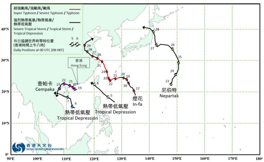
Overview of Tropical Cyclone in July 2021
|
Five tropical cyclones occurred over the western North Pacific and the South China Sea in July 2021. Two tropical depressions and Cempaka necessitated the issuance of the tropical cyclone warning signals by the Hong Kong Observatory. The area of low pressure over the western North Pacific around 740 km east-northeast of Manila developed into a tropical depression in the small hours on 5 July. The tropical depression then moved northwestwards across the Luzon Strait. It reached its peak intensity that night with an estimated sustained wind of 55 km/h near its centre. The tropical depression skirted past the southwestern coastal waters of Taiwan and weakened rapidly on the morning of 6 July. It dissipated near the Taiwan Strait shortly after noon. Another area of low pressure over the central part of the South China Sea around 230 km south-southeast of Xisha intensified into a tropical depression on the night of 5 July. It tracked generally northwest to north-northwestwards towards Hainan Island on 6 July and reached its peak intensity that night with an estimated sustained wind of 55 km/h near its centre. After moving across the southwestern part of Hainan Island, the tropical depression entered Beibu Wan on 7 July. It made landfall over the northern part of Vietnam the next day and then weakened into an area of low pressure. For detailed information of these two tropical depressions including their impact to Hong Kong, please refer to the Tropical Cyclone Report of these two tropical depressions. In-fa formed as a tropical depression over the western North Pacific about 1 110 km southeast of Naha in the small hours on 17 July. It moved north-northwestwards and intensified gradually. In-fa intensified into a severe tropical storm on the morning of 19 July, and took a west to west-southwesterly track to skirt past the vicinity of Ryukyu Islands. It further intensified into a typhoon on the night of 20 July and reached its peak intensity with an estimated maximum sustained wind of 145 km/h near its centre in the next morning. In-fa slowed down on 22 July and turned to move north-northwestwards across the East China Sea in the following three days. In-fa made landfall over the coast of the northern part of Zhejiang on 26 July and weakened gradually. It finally degenerated into an area of low pressure over Shandong on 29 July. According to press reports, there were torrential rain and extensive flooding over the vicinity of eastern China under the persistent influence of In-fa. More than 2.7 million people were affected and around 1 100 houses were damaged. Cempaka formed as a tropical depression over the northern part of the South China Sea about 180 km south-southwest of Hong Kong on the night of 18 July. It moved generally northwest to west-northwestwards slowly towards the coast of western Guangdong and intensified rapidly. Cempaka intensified into a typhoon in the small hours on 20 July and reached its peak intensity with an estimated maximum sustained wind of 120 km/h near its centre. It started to weaken at night and made landfall near Yangjiang. Cempaka moved across western Guangdong and inland Guangxi, and weakened into a tropical depression progressively on 21 July. It turned to move south-southwestwards the next day and entered Beibu Wan on 23 July. Cempaka finally degenerated into an area of low pressure over Beibu Wan on 24 July. For detailed information of Cempaka including its impact to Hong Kong, please refer to the Tropical Cyclone Report of Cempaka. Nepartak formed as a tropical depression over the western North Pacific about 720 km east-southeast of Iwo Jima on the morning of 23 July and intensified into a tropical storm that night. It generally moved north-northeastwards in the following two days, and weakened into a tropical depression. Nepartak then gradually turned to move westwards across the seas east of Japan on 26 July and re-intensified into a tropical storm that night. Nepartak reached its peak intensity with an estimated maximum sustained wind of 75 km/h near its centre in the small hours on 27 July. It then turned to move northwestwards and finally weakened into an area of low pressure over the seas north of Honshu of Japan on 28 July. |

Provisional Tropical Cyclone Tracks in July 2021