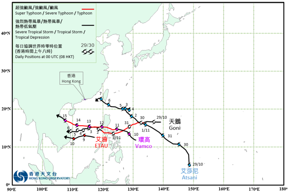
Overview of Tropical Cyclones in November 2020
|
Four tropical cyclones occurred over the western North Pacific and the South China Sea in November 2020. Goni formed as a tropical depression over the western North Pacific about 1960 km east of Manila on the afternoon of 28 October. It moved west to west-southwestwards and intensified rapidly. Goni intensified into a super typhoon on the morning of 30 October and reached its peak intensity in the small hours on 1 November with an estimated maximum sustained wind of 275 km/h near its centre. Goni is the most intense tropical cyclone in the region since Super Typhoon Haiyan in November 2013. It moved across the central part of the Philippines and weakened that night. Goni traversed the central part of the South China Sea in the following couple of days and degenerated into an area of low pressure after making landfall over the central part of Vietnam on 6 November. According to press reports, the Philippines was directly hit by Super Typhoon Goni. At least 25 people were killed and over 170 000 houses were damaged. Atsani formed as a tropical depression over the western North Pacific about 1010 km south-southeast of Guam on the morning of 29 October. It moved generally northwestwards and intensified gradually. Atsani intensified into a tropical storm that night. It continued to move towards the seas east of the Philippines in the following two days. Atsani began to slow down in the small hours on 3 November and lingered over the seas northeast of the Philippines. Atsani intensified into a severe tropical storm on 4 November and reached its peak intensity the next day with an estimated maximum sustained wind of 105 km/h near its centre. It then picked up its speed to move west-northwestwards towards the coastal waters of southern part of Taiwan. Atsani entered the northeastern part of the South China Sea on 7 November and weakened rapidly. It finally degenerated into an area of low pressure over Taiwan Strait on 8 November. Etau formed as a tropical depression over the southern part of the South China Sea about 390 km northeast of Nansha on the night of 8 November and moved westwards. It intensified into a tropical storm on 9 November and reached its peak intensity that night with an estimated maximum sustained wind of 75 km/h near its centre. Etau made landfall over the southern part of Vietnam on 10 November and weakened rapidly. It degenerated into an area of low pressure over Indo-China that night. Vamco formed as a tropical depression over the western North Pacific about 1130 km east-southeast of Manila on the afternoon of 9 November. It moved west-northwestwards and intensified rapidly. Vamco developed into a severe typhoon on the night of 11 November and moved across Luzon. It weakened into a typhoon the next morning and entered the central part of the South China Sea. It tracked westwards and re-intensified into a severe typhoon on 14 November, reaching its peak intensity in the morning with an estimated maximum sustained wind of 165 km/h near its centre. Vamco then weakened rapidly and made landfall over the central part of Vietnam the next afternoon. It finally degenerated into an area of low pressure over Indo-China in the small hours on 16 November. According to press reports, Vamco left at least 101 deaths, 85 injuries and 10 missing in the Philippines during its passage. In Vietnam, at least one people was killed and 5 others were injured during the passage of Vamco. |

Provisional Tropical Cyclone Tracks in November 2020