Overview of Tropical Cyclones in November 2019
|
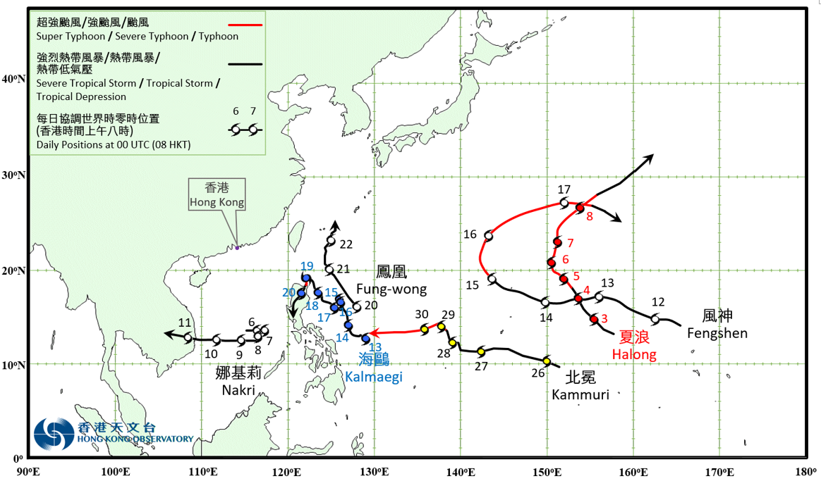
Six tropical cyclones occurred over the western North Pacific and the South China Sea in November 2019. Halong formed as a tropical depression over the western North Pacific about 1 390 km east of Guam on the night of 2 November. It tracked northwestwards and intensified gradually. Halong developed into a super typhoon on 5 November and reached its peak intensity with an estimated sustained wind of 250 km/h near its centre. Halong then turned to move north to northeastwards gradually and weakened in the following three days. It finally evolved into an extratropical cyclone over the seas on 9 November. Nakri formed as a tropical depression over the southern part of the South China Sea about 370 km north-northeast of Nansha on the afternoon of 5 November. It moved slowly at first and lingered over the southern part of the South China Sea. Nakri developed into a severe tropical storm on the morning of 7 November and reached its peak intensity on the afternoon of 8 November with an estimated sustained wind of 110 km/h near its centre. Nakri turned to move west towards the central part of Vietnam afternoon and finally degenerated into an area of low pressure over the central part of Vietnam on 11 November. According to press reports, Nakri brought at least two deaths during its passage to Vietnam. Fengshen formed as a tropical depression over the western North Pacific about 2 220 km east of Guam on the night of 11 November. It generally moved west to west-northwest and intensified gradually. Fengshen intensified into a typhoon on the morning of 15 November and started to turn northeastwards. It further intensified into a severe typhoon that night and reached its peak intensity with an estimated sustained wind of 165 km/h near its centre. Fengshen turned to move southeast on 17 November and weakened rapidly. It degenerated into an area of low pressure over sea areas that night. Kalmaegi formed as a tropical depression over the western North Pacific about 890 km east-southeast of Manila on the morning of 13 November. It generally move northwest to north-northwest towards the seas east of Luzon at first. Kalmaegi slowed down on 15 and 16 November, and lingered over the seas east of Luzon. It intensified into a tropical storm on the small hours of 17 November and tracked generally northwest towards the vicinity of Luzon Strait. Kalmaegi further intensified into a typhoon on the morning of 19 November and reached its peak intensity with an estimated sustained wind of 120 km/h near its centre. Kalmaegi turned to move south-southwest and made landfall over the northern part of Luzon the next day. Kalmaegi weakened rapidly after landfall and finally degenerated into an area of low pressure over Luzon on the afternoon of 20 November. Fung-wong formed as a tropical depression over the western North Pacific about 760 km east-northeast of Manila on 20 November. It moved towards the seas east of Taiwan and intensified gradually. Fung-wong developed into a severe tropical storm on 21 November and reached its peak intensity with an estimated maximum sustained wind of 110 km/h near its centre. Fung-wong weakened rapidly afterwards and finally degenerated into an area of low pressure over the sea areas east of Taiwan on the small hours of 23 November. Kammuri formed as a tropical depression over the western North Pacific about 830 km east-southeast of Guam on the early morning of 26 November. It move west-northwest and intensified gradually. Kammuri developed into a typhoon on 29 November and moved towards the sea areas east of the Philippines. |
Provisional Tropical Cyclone Tracks in Novmeber 2019