Overview of Tropical Cyclones in October 2019
|
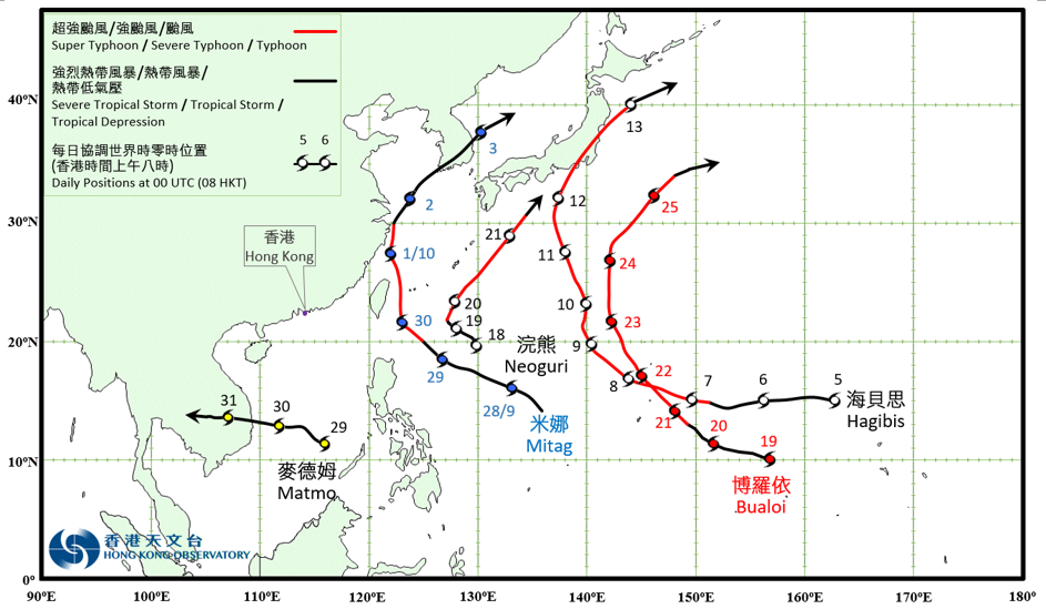
Five tropical cyclones occurred over the western North Pacific and the South China Sea in October 2019. Mitag formed as a tropical depression over the western North Pacific about 1 610 km east of Manila on the night of 27 September and moved towards northwest to west-northwest and intensified gradually. Mitag developed into a typhoon on 29 September. It turned to move northwards across the sea areas east of Taiwan the next day and attended its peak intensity with an estimated maximum sustained wind of 145 km/h near its centre. Mitag then moved towards the east China coast and weaken gradually. It moved across the vicinity of the east China coast on the night of 1 October and weakened into a tropical storm. Mitag turned to move northeast across the southern part of the Korean Peninsula the next day. It finally evolved into an extratropical cyclone over the seas east of the Korean Peninsula on 3 October. According to press reports, Mitag brought at least 12 injuries and over 60 000 households without electricity supply in Taiwan during its passage. Under the influence of Mitag, there were at least three deaths and one missing in Zhanjiang, with direct economic loss of around 1.8 billion RMB. Mitag also caused at least 12 deaths, 11 injuries and two missing in the Republic of Korea. Hagibis formed as a tropical depression over the western North Pacific about 1 930 km east of Guam on 5 October. It move westwards and intensified rapidly. Hagibis developed into a super typhoon on 7 October and reached its peak intensity with an estimated sustained wind of 230 km/h near its centre. Hagibis then turned to move north to north-northwest gradually towards the sea areas south of Japan in the following four days. It swept across Tokyo and Kanto region on 12 October and weakened into a typhoon that night. Hagibis finally evolved into an extratropical cyclone over the sea areas east of Hokkaido, Japan on 13 October. Facing the direct hit of Hagibis, record-breaking rainfall were registered in many places of Kanto region of Japan. The daily rainfall of 922.5 mm recorded in Hakone of Kanagawa on 12 October is the highest record in Japan. According to press reports, Hagibis brought torrential rain and squalls to Japan which triggered extensive flooding and power outage, leaving at least 93 deaths, 468 injuries and three others missing. There were over 400 000 households without electricity supply. Transportation services in Kanto region were paralyzed. Neoguri formed as a tropical depression over the western North Pacific about 1 100 km east-northeast of Manila on the morning of 18 October. It moved slowly at first and intensified rapidly. Neoguri turned to move north-northeast towards the vicinity of the Ryukyu Islands the next night. It intensified into a severe typhoon on 20 October and reached its peak intensity with an estimated sustained wind of 165 km/h near its centre. Neoguri then weakened gradually and evolved into an extratropical cyclone over sea areas south of Honshu, Japan the next evening. Bualoi formed as a tropical depression over the western North Pacific about 1 350 km east-southeast of Guam on the morning of 19 October. It tracked generally northwestwards and intensified rapidly. Bualoi intensified into a super typhoon on the afternoon of 22 October and reached its peak intensity with an estimated sustained wind of 195 km/h near its centre. It turned to track northeast and weakened gradually in the following two days. Bualoi finally evolved into an extratropical cyclone over sea areas east of Japan on the afternoon of 25 October. Matmo formed as a tropical depression over the southern part of the South China Sea about 210 km east-northeast of Nansha on the morning of 29 October. It moved generally westward towards the southern part of Vietnam and intensified gradually. Matmo intensified into a severe tropical storm the next night and reached its peak intensity with an estimated sustained wind of 90 km/h near its centre. Matmo moved across the southern part of Vietnam on 31 October and then degenerated into an area of low pressure over Indo-China in the evening. |

Provisional Tropical Cyclone Tracks in October 2019