Overview of Tropical Cyclones in September 2019
|
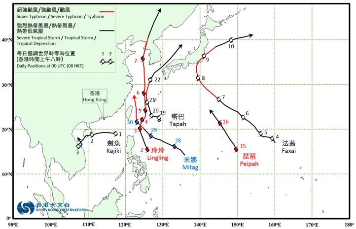
Six tropical cyclones occurred over the western North Pacific and the South China Sea in September 2019, of which Kajiki necessitated the issuance of tropical cyclone warning signals by the Observatory. Kajiki formed as a tropical depression over the northern part of the South China Sea at about 480 km southeast of Hong Kong on the morning of 1 September and moved westwards across the northern part of the South China Sea. Kajiki intensified slightly during the day with an estimated maximum sustained wind reaching 55 km/h near its centre. It turned to track southwestwards after moving across the southeastern part of Hainan Island on the morning of 2 September. Kajiki made landfall over the coast of central Vietnam and lingered over the region on 3 September. It finally degenerated into an area of low pressure over the coastal waters of central Vietnam the next day. According to press reports, Kajiki left at least six deaths and ten missing in Vietnam during its passage. For detailed information of Kajiki including its impact to Hong Kong, please refer to the Tropical Cyclone Report of Kajiki. Lingling formed as a tropical depression over the western North Pacific about 1 000 km southeast of Gaoxiong on the morning of 2 September. It tracked generally northwards towards the sea areas east of Taiwan and intensified rapidly. It developed into a super typhoon near Miyakojima of Japan on 5 September and reached its peak intensity with an estimated sustained wind of 205 km/h near its centre. Lingling moved across the East China Sea and then the Yellow Sea afterwards. It made landfall over the northern part of the Korean Peninsula on 7 September. Lingling finally evolved into an extratropical cyclone over the northeastern part of China on 8 September. According to press reports, Lingling brought torrential rain and squalls to Miyakojima of Japan during its passage, leading to at least five injuries. In the Republic of Korea, Lingling caused at least three deaths and 24 injuries, and more than 160 000 households without electricity supply. Lingling also left at least five people dead and three others injured in DPR Korea. Faxai formed as a tropical depression over the western North Pacific about 2 120 km east-southeast of Iwo Jima on the small hours of 4 September. It tracked northwestwards towards the sea areas south of Japan and intensified gradually. Faxai intensified into a severe typhoon on 8 September and reached its peak intensity with an estimated sustained wind of 175 km/h near its centre. It then turned to move northeastwards gradually. Faxai skirted past near Tokyo on the small hours of 9 September and weakened. It evolved into an extratropical cyclone over the sea areas east of Japan on 10 September. Facing the direct hit of Faxai, record-breaking wind speeds were registered in many places of Kanto of Honshu. According to press reports, Faxai brought torrential rain and squalls to Japan during its passage, leaving at least four deaths and 145 injuries. There were over 930 000 households without electricity supply in Kanto of Honshu and at least 350 flooding reports in Tokyo. Transportation services in Kanto of Honshu were paralyzed with at least 283 flights cancelled. The traffic to Narita International Airport was also suspended, forcing over 17 000 passengers to stay at the airport. Peipah formed as a tropical depression over the western North Pacific about 1 350 km southeast of Iwo Jima on the morning of 15 September. It moved northwestwards and intensified gradually. Peipah developed into a tropical storm on the night of 15 September and reached its peak intensity with an estimated sustained wind of 65 km/h near its centre. Peipah weakened rapidly the next day and degenerated into an area of low pressure over sea on the afternoon. Tapah formed as a tropical depression over the western North Pacific about 840 km east-southeast of Taibei on the morning of 18 September and drifted slowly at first. Tapah intensified into a typhoon on the morning of 21 September and reached its peak intensity with an estimated sustained wind of 120 km/h near its centre. Tapah picked up speed to move north across the East China Sea that day. It turned to move northeastwards on 22 September and evolved into an extratropical cyclone over the sea areas north of Honshu, Japan the next morning. According to press reports, Tapah caused at least two deaths and 56 injuries in Japan during its passage. Tapah also left at least one death and 26 injuries in the Republic of Korea. Mitag formed as a tropical depression over the western North Pacific about 1 610 km east of Manila on the night of 27 September. It moved towards northwest to west-northwest and intensified gradually. Mitag developed into a typhoon on 29 September. It turned to move northwards across the sea areas east of Taiwan the next day. |

Provisional Tropical Cyclone Tracks in September 2019