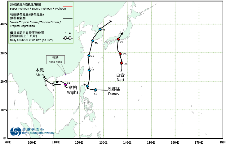
Overview of Tropical Cyclones in July 2019
Four tropical cyclones occurred over the western North Pacific and the South China Sea in July 2019, of which Mun and Wipha necessitated the issuance of the tropical cyclone warning signals by the Observatory. The first No. 8 Gale or Storm Signal in the year was issued on 31 July during the passage of Wipha.
Mun formed as a tropical depression over the northern part of the South China Sea about 240 km southeast of Haikou on the afternoon of 2 July and moved generally westwards. After moving across Hainan Island on the morning of 3 July, Mun entered Beibu Wan and intensified slightly, reaching its peak intensity with an estimated sustained wind of 55 km/h near its centre. Moving northwestwards across Beibu Wan, Mun weakened into an area of low pressure over the northern part of Vietnam on the morning of 4 July.
According to press reports, Mun disrupted sea, land, air transportation in Hainan Island. For detailed information of Mun including its impact to Hong Kong, please refer to the Tropical Cyclone Report of Mun.
Danas formed as a tropical depression over the western North Pacific about 1120 km east-northeast of Manila and moved westwards at first. It turned to move north-northeastwards on 17 July. Danas intensified into a tropical storm on the morning of 18 July, reaching its peak intensity next day with an estimated sustained wind of 85 km/h near its centre. It continued to track north-northeastwards across the Korean Peninsula on 20 July and weakened gradually. Danas finally evolved into an extratropical cyclone over the sea areas east of the Korean Peninsula on 21 July.
According to press reports, the torrential rain associated with Danas caused at least four deaths in the Philippines.
Nari formed as a tropical depression over the western North Pacific about 430 km west-southwest of Iwo Jima on the morning of 24 July and moved generally northwards. It intensified into a tropical storm on the morning of 26 July, reaching its peak intensity with an estimated sustained wind of 65 km/h near its centre. Nari then weakened gradually and degenerated into an area of low pressure over Honshu of Japan on the afternoon of 27 July.
Wipha formed as a tropical depression over the northern part of the South China Sea about 510 km south of Hong Kong on the afternoon of 30 July. It drifted northwards slowly during that night and next morning. Wipha intensified into a tropical storm on the morning of 31 July later, reaching its peak intensity with an estimated maximum sustained wind of 85 km/h near its centre. It started to pick up speed to move west-northwest towards Hainan Island in the afternoon. For detailed information of Wipha including its impact to Hong Kong, please refer to the Tropical Cyclone Report of Wipha.

Provisional Tropical Cyclone Tracks in July 2019