Overview of Tropical Cyclones
Overview of Tropical Cyclones in July 2018
Thursday, 6th September 2018
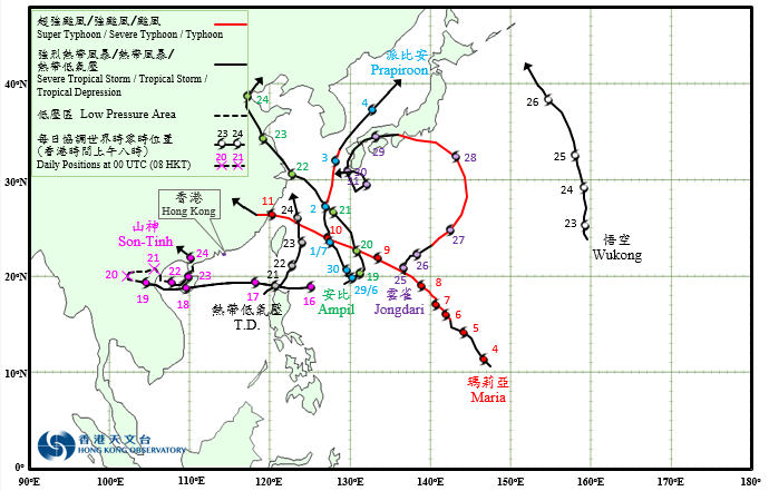
Seven tropical cyclones occurred over the western North Pacific and the South China Sea in July 2018, of which Son-Tinh necessitated the issuance of the tropical cyclone warning signals on two separate occasions owing to its irregular track by the Observatory.
Prapiroon formed as a tropical depression over the western North Pacific about 750 km south-southeast of Okinawa on the early morning of 29 June. It tracked generally north-northwestwards and intensified gradually. Prapiroon turned north to northeastwards on 1 July and intensified into a typhoon on the morning of 2 July, reaching its peak intensity with an estimated sustained wind of 120 km/h near its centre. Prapiroon started to weaken afterwards, before finally evolving into an extratropical cyclone over the sea areas north of Honshu, Japan on 4 July.
According to press reports, at least four people were injured in Okinawa during the passage of Prapiroon. It also brought squalls and heavy rain to Kyushu and Shikoku of Japan, leaving one dead and 16 injured, and electricity supply to over 50,000 households interrupted in Kyushu. At least one people was killed and one was missing in the Republic of Korea during the passage of Prapiroon.
Maria formed as a tropical depression over the western North Pacific about 430 km southeast of Guam on the night of 3 July. It tracked generally northwestwards and intensified rapidly. It developed into a super typhoon on the morning of 6 July and reached its peak intensity with an estimated sustained wind of 220 km/h near its centre on the morning of 9 July. Maria swept across the sea areas to the south of Okinawa and then north of Taiwan and started to weaken gradually. Maria made landfall over the coast of Fujian on the morning of 11 July and dissipated over Jiangxi the next day.
According to press reports, at least one people was killed and eight were injured in Taiwan during the passage of Maria. Electricity supply to around 126,000 households were interrupted. In Fujian and Zhejiang, at least one person was killed, nine were missing and 550,000 people were affected during the passage of Maria. There were backflow of sea water in many places.
Son-Tinh formed as a tropical depression over the western North Pacific about 650 km northeast of Manila on 16 July. It moved quickly westwards across the northern part of the South China Sea, Hainan Island and Beibu Wan in the next two days. It degenerated into an area of low pressure over the northern part of Vietnam on 19 July. The low pressure area associated with the remnant of Son-Tinh made a sharp turn to the east over the Indo-China on 20 July. It re-intensified into a tropical depression over Beibu Wan and took a northeasterly turn, sweeping across the northwestern part of Hainan Island on 22 July. Son-Tinh then turned north and moved across Leizhou Peninsula on 23 July, before dissipating over Guangxi on 24 July. Son-Tinh necessitated the issuance of the tropical cyclone warning signals on two separate occasions by the Observatory during its passage. Details can be found in the Tropical Cyclone Report of Son-Tinh.
Ampil formed as a tropical depression over the western North Pacific about 800 km south-southeast of Okinawa on the night of 18 July and moved slowly at first. It intensified into a tropical storm the next day and took on a northwest course towards the East China Sea. Ampil further intensified into a severe tropical storm on the night of 20 July, reaching its peak intensity with an estimated sustained wind of 90 km/h near its centre. It moved across the vicinity of Jiangsu and weakened on 22 July. Ampil continued to sweep across Shandong and Hebei the next day, before evolving into an extratropical cyclone over the northeastern part of China on 24 July.
According to press reports, at least one people was killed in China during the passage of Ampil. Near 1.8 million people were affected with a direct economic loss around 1.19 billion RMB.
A tropical depression formed over the western North Pacific about 390 km southwest of Dongsha on 21 July. It tracked northeastwards across the Luzon Strait, heading towards the seas east of Taiwan. The tropical depression reached its peak intensity with an estimated sustained wind of 55 km/h near its centre on the early morning of 22 July. It then turned to move northwards and weakened into an area of low pressure over the East China Sea the next day.
Wukong formed as a tropical depression over the western North Pacific about 890 km northwest of Wake Island on the night of 22 July. Tracking generally northwards, it intensified gradually. Wukong intensified into a severe tropical storm on 25 July, reaching its peak intensity with an estimated sustained wind of 90 km/h near its centre. It finally evolved into an extratropical cyclone over the seas east of Japan on 26 July.
Jongdari formed as a tropical depression over the western North Pacific about 690 km southwest of Iwo Jima on 25 July. Moving generally northeastwards, it intensified gradually. Jongdari intensified into a typhoon on the night of 26 July. It moved across the southern part of Honshu, and then the northern part of Kyushu of Japan on 29 July, and weakened into a tropical storm. Jongdari made a counter-clockwise loop over the seas south of Kyushu in the next two days and moved towards the East China Sea.

|
|---|
Provisional Tropical Cyclone Tracks in July 2018