Overview of Tropical Cyclones in September 2017
Overview of Tropical Cyclones in September 2017
Wednesday, 1st November 2017
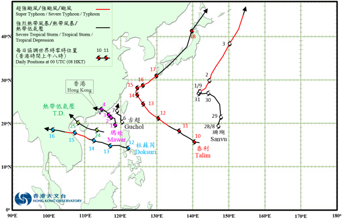
Six tropical cyclones occurred over the western North Pacific and the South China Sea in September 2017, of which Mawar and a tropical depression necessitated the issuance of tropical cyclone warning signals by the Observatory during the month.
After developing into a typhoon on 31 August, Sanvu lingered over the sea areas north of Iwo Jima and reached its peak intensity with an estimated sustained wind of 145 km/h near its centre on the morning of 1 September. It started to track north-northeastwards across the sea areas east of Japan and weakened gradually. Sanvu finally evolved into an extratropical cyclone over the western North Pacific east of Hokkaido on the night of 3 September.
Mawar formed as a tropical depression over the northern part of the South China Sea about 270 km east-southeast of Dongsha on the afternoon of 31 August. Moving initially northwards the next day, it turned slowly northwestwards and intensified into a tropical storm during the night. Mawar gradually edged towards the coast of eastern Guangdong over the next couple of days, intensifying into a severe tropical storm on the afternoon of 2 September and reaching its peak intensity with an estimated sustained wind of 90 km/h near its centre. It then weakened into a tropical storm on 3 September and made landfall near Shanwei that night before degenerating into an area of low pressure over inland Guangdong the next day.
According to press reports, torrential rain and squalls brought by Mawar caused severe flooding in the Chaozhou-Shantou region and the Pearl River Delta and seriously disrupted transportation services. Electricity supply to around 110 000 households were interrupted in Guangdong, and there were reports of flooding in many places in Macao. For detailed information of Mawar including its impact on Hong Kong, please refer to the Tropical Cyclone Report of Mawar.
Guchol formed as a tropical depression over the Luzon Strait about 260 km south of Gaoxiong on the morning of 6 September and drifted generally north-northwestwards. It reached its peak intensity with an estimated sustained wind of 55 km/h near its centre that afternoon and degenerated into an area of low pressure over the Taiwan Strait the next day.
Talim formed as a tropical depression over the western North Pacific about 390 km northwest of Guam on the early morning of 10 September. It moved generally northwestwards towards the sea areas east of Taiwan and intensified gradually. Talim reached typhoon intensity on the night of 11 September before intensifying further into a super typhoon on the morning of 14 September and reaching its peak intensity with an estimated sustained wind of 185 km/h near its centre. After taking a turn to the northeast, Talim gradually weakened over the next few days. It swept across Kyushu, Shikoku, Honshu and Hokkaido of Japan on 17 and 18 September before evolving into an extratropical cyclone over the sea areas north of Hokkaido.
According to press reports, at least two persons were killed and three were reported missing in Japan during the passage of Talim. Transportation services were seriously affected.
Doksuri formed as a tropical depression off the east coast of Luzon about 120 km east-southeast of Manila on the morning of 12 September and moved westwards crossing Luzon during the day. It traversed the central part of the South China Sea and intensified gradually over the next couple of days. Doksuri intensified into a severe typhoon and attained its peak intensity with an estimated sustained wind of 165 km/h near its centre before making landfall over the central part of Vietnam on 15 September. After landfall, Doksuri weakened rapidly and dissipated over the northern part of Thailand on 16 September.
According to press reports, Doksuri left at least four people dead in the Philippines during its passage. Doksuri also brought torrential rain and squalls to Vietnam, causing at least nine deaths with more than 110 people injured and about 150 000 houses damaged.
A tropical depression formed over the central part of the South China Sea about 570 km south-southeast of Hong Kong on the night of 23 September and tracked generally west-northwestwards. It reached its peak intensity the next morning with an estimated sustained wind of 55 km/h near its centre. Taking on a northwestward course, the tropical depression then moved across Hainan Island and Beibu Wan before weakening into an area of low pressure over the northern part of Vietnam on the night of 25 September. For detailed information of the tropical depression including its impact on Hong Kong, please refer to its Tropical Cyclone Report.
 |
|---|
Tropical Cyclone Tracks in September 2017