Overview of Tropical Cyclones in July 2017
Overview of Tropical Cyclones in July 2017
Friday, 18th August 2017
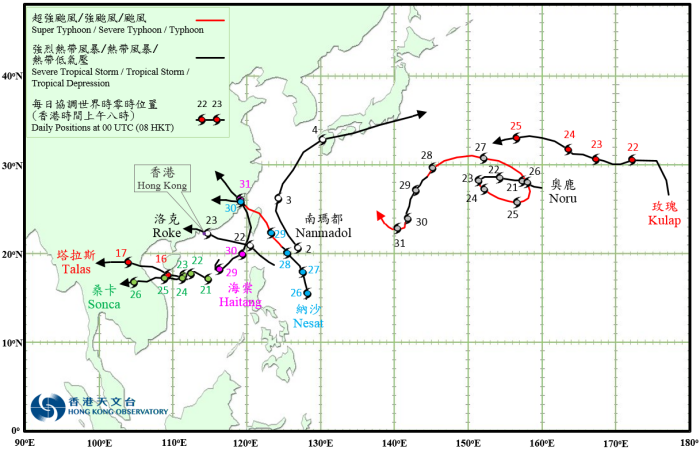
The development of tropical cyclones over the western North Pacific and the South China Sea was very active in July 2017 with eight tropical cyclones forming in the region, of which Roke necessitated the issuance of tropical cyclone signals by the Hong Kong Observatory.
Nanmandol formed as a tropical depression over the western North Pacific about 750 km southeast of Taibei on the morning of 2 July. It moved generally northwestwards and developed into a tropical storm that afternoon. Nanmandol turned north-northeastwards in the general direction of Japan the next day and further intensified into a severe tropical storm, reaching its peak intensity with an estimated sustained wind of 105 km/h near its centre. It swept across Kyushu, Shikoku and the south coast of Honshu on 4 July and weakened gradually. Nanmandol finally evolved into an extratropical cyclone over the seas east of Japan in the small hours of 5 July.
According to press reports, at least five persons were injured in Japan during the passage of Nanmandol. There were extensive landslides and electricity supply to nearly 70 000 households was disrupted. Transportation services were seriously affected.
Talas formed as a tropical depression over the central part of the South China Sea about 50 km northwest of Xisha on the afternoon of 15 July. Talas moved west-northwest towards northern Vietnam and intensified gradually, becoming a severe tropical storm on the night of 16 July and reached its peak intensity with an estimated sustained wind of 90 km/h near its centre. It made landfall over the coast of northern Vietnam in the small hours of 17 July and started to weaken. Talas finally degenerated into an area of low pressure over the northern part of Thailand that night.
According to press reports, at least 14 persons were killed and thousands of houses were destroyed during the passage of Talas in Vietnam.
Noru formed as a tropical depression over the western North Pacific about 1140 km northwest of Wake Island on the night of 20 July. Moving generally westwards, it intensified gradually and developed into a typhoon on 23 July. Under the influence of another tropical cyclone Kulap to the east, Noru made a slow counter-clockwise loop in the next three days. It started to accelerate west-northwestwards and then westwards on 26 and 27 July, before turning to the southwest on 28 July and temporarily weakened. It then re-intensified again on 30 July and became a super typhoon the next day, turning to the west-northwest towards the sea areas east of the Ryukyu Islands.
Kulap formed as a tropical depression over the western North Pacific about 1340 km northeast of Wake Island on the morning of 21 July. Moving northwards at first, it intensified into a tropical storm in the afternoon. It turned westwards the next day and reached its peak intensity with an estimated sustained wind of 75 km/h near its centre. Kulap headed west-northwestwards on 23 and 24 July and gradually getting closer to Noru. Under the influence of Noru’s circulation, Kulap moved around Noru on 25 July and weakened rapidly into an area of low pressure.
Sonca formed as a tropical depression over the central part of the South China Sea about 260 km east of Xisha on the morning of 21 July and moved west-northwestwards. It slowed down the next day and lingered over the sea areas southeast of Hainan Island. Sonca intensified into a tropical storm on the night of 24 July and accelerated to the west towards Vietnam. It reached its peak intensity with an estimated sustained wind of 75 km/h near its centre the next morning. Sonca made landfall over Vietnam on the afternoon of 25 July and weakened. It finally degenerated into an area of low pressure over Lao PDR the next morning.
Roke originated from a tropical depression that developed over the sea areas east of northern Luzon on the afternoon of 21 July. It moved across the Luzon Strait on 22 July and after entering the northeastern part of the South China Sea, took on a west-northwestward course and headed steadily towards the Pearl River Delta. It intensified into a tropical storm that evening, reaching its peak intensity with an estimated sustained wind of 65 km/h near its centre. Roke made landfall near Hong Kong on the morning of 23 July and weakened into a tropical depression during the day. It finally degenerated into an area of low pressure over inland Guangdong in the evening.
According to press reports, Roke brought squally showers to Guangdong during its passage. A vessel sunk over the seas about 70 km east of Hong Kong and all 12 crew members on board were rescued.
Nesat formed as a tropical depression over the western North Pacific about 770 km east of Manila on the morning of 26 July. Moving generally northwards at first, it turned to the northwest the next day in the general direction of Taiwan and intensified gradually. Nesat developed into a typhoon on the night of 28 July and reached its peak intensity the next morning with an estimated sustained wind of 145 km/h. After sweeping across the northern part of Taiwan on the night of 29 July, Nesat made landfall over the coast of Fujian the next morning and dissipated inland during the night.
Haitang formed as a tropical depression about 160 km south-southwest of Dongsha on the afternoon of 28 July and lingered over the northern part of the South China Sea at first. Under the influence of the circulation of Nesat, Haitang accelerated northeastwards on 29 July and intensified into a tropical storm, reaching its peak intensity with an estimated sustained wind of 75 km/h that night. After crossing the Luzon Strait, it swept past the west coast of Taiwan on a northward track on 30 July and turned north-northwestwards to strike the coast of Fujian the next morning near where Nesat made landfall just 24 hours earlier. Haitang then weakened and finally degenerated into an area of low pressure over inland Fujian on the night of 31 July.
According to press reports, there were at least 131 people injured and one reported missing in Taiwan with Nesat and Haitang hitting the island in quick succession. More than 670 000 households were without electricity supply. Nesat and Haitang also brought torrential rain and severe flooding to Fujian, Zhejiang and Jiangxi, with more than 200 000 people evacuated in Fujian.
 |
|---|
Tropical Cyclone Tracks in July 2017
 |
|---|
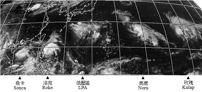
Himawari-8 infra-red image at 0600 UTC on 21 July 2017, a day of active cyclogenesis with the pair of Kulap and Noru to the east and the pair of Roke and Sonca to the west. There was also a low pressure area in between over the sea areas south of Japan.
[The satellite imagery was originally captured by the Himawari-8 (H-8) of Japan Meteorological Agency (JMA).]