Overview of Tropical Cyclones in October 2016
Overview of Tropical Cyclones in October 2016
Thursday, 17th November 2016
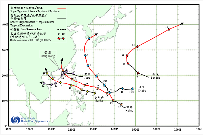
Five tropical cyclones occurred over the western North Pacific and the South China Sea in October 2016. Three of them (Aere, Sarika and Haima) necessitated the issuance of tropical cyclone warning signals by the Observatory in the month.
Chaba formed as a tropical depression over the western North Pacific about 570 km east-northeast of Guam on the early morning of 28 September. Moving generally westward at first, it turned north-northwestwards on 30 September in the general direction of the Ryukyu Islands and intensified gradually. Chaba developed into a super typhoon on the early morning of 3 October, reaching its peak intensity at night with an estimated sustained wind of 220 km/h. After sweeping past the Ryukyu Islands, it moved across the East China Sea on a northerly track towards the southern part of the Korean Peninsula and finally evolved into an extratropical cyclone over the sea areas north of Honshu, Japan on the night of 5 October.
According to press reports, transportation services in Okinawa were seriously affected during the passage of Chaba. Chaba also wreaked havoc and caused extensive flooding in the southern part of the Republic of Korea, resulting in at least seven deaths with three others missing. Electricity supply to about 25 000 households in Jeju was interrupted.
Aere formed as a tropical depression over the western North Pacific about 900 km east of Dongsha on the afternoon of 5 October. Moving west to west-northwestwards, it moved across the Luzon Strait and entered the northeastern part of the South China Sea the next day while intensifying into a tropical storm. After crossing the sea areas south of Dongsha in the early morning on 7 October, Aere slowed down and drifted northwards during the day, reaching its peak intensity in the afternoon with an estimated sustained wind of 85 km/h near its centre. Aere moved northeastwards slowly on 8 October and became almost stationary the next day as it weakened gradually. Aere picked up speed and turned to move southwestwards on 10 October, degenerating into an area of low pressure near Dongsha that night. However, its remnant low pressure area continued to track to the southwest towards the sea areas around Xisha over the next couple of days. It re-intensified into a tropical depression south of Hainan Island on the morning of 13 October and turned westwards. After making landfall over the central part of Vietnam early next morning, Aere weakened into an area of low pressure before dissipating further inland.
According to press reports, the outer circulation of Aere brought heavy rain to southern Taiwan and caused flooding in some areas. Land and sea transportation services were affected.
Songda formed as a tropical depression over the western North Pacific about 1 640 km east-southeast of Iwo Jima on the afternoon of 8 October. It moved generally northwestwards and intensified gradually. Songda developed into a typhoon over the sea areas east of Iwo Jima on the morning of 10 October and turned northwards. It picked up speed towards the northeast and intensified into a super typhoon over the next couple of days, reaching its peak intensity with an estimated sustained wind of 185 km/h near its centre before finally evolving into an extratropical cyclone on 13 October.
Sarika formed as a tropical depression over the western North Pacific about 1 060 km east of Manila on the morning of 13 October. Taking a west-northwesterly track towards the Philippines, it intensified into a tropical storm that night. Sarika further intensified rapidly the next day and developed into a super typhoon on the night of 15 October, reaching its peak intensity with an estimated sustained wind of 185 km/h near its centre. Sarika weakened into a typhoon while moving across Luzon in the early morning on 16 October. After entering the South China Sea, it re-organized and re-intensified into a severe typhoon that night. Sarika made landfall over Hainan Island on the morning of 18 October and turned northwestwards. It moved across Beibu Wan on 19 October and dissipated over inland Guangxi later that day.
According to press reports, at least three persons were killed and three others were missing in the Philippines during the passage of Sarika. There were extensive landslides and many houses collapsed. In Guangdong, Guangxi and Hainan, at least 3.7 million people were affected with direct economic loss of around 5.5 billion RMB.
Haima formed as a tropical depression over the western North Pacific about 710 km south of Guam on the afternoon of 14 October. Moving generally northwestwards, Haima intensified gradually and developed into a super typhoon on the night of 17 October. Tracking to the west-northwest, it reached its peak intensity the next day with an estimated sustained wind of 230 km/h near its centre. Haima moved across northern Luzon on the early morning of 20 October and weakened into a typhoon. It then moved northwestwards and entered the northeastern part of the South China Sea during the day. Haima turned northwards on 21 October and made landfall near Shanwei in eastern Guangdong that afternoon, before finally degenerating into an area of low pressure over Jiangxi during the night.
According to press reports, Haima wreaked havoc in northern Luzon with extensive flooding and landslides as well as the collapse of many houses. At least eight people were killed and more than 90 000 people had to be evacuated. Haima also brought heavy rain and squalls to Guangdong and Fujian. At least 1.8 million people were affected and around 600 houses collapsed. Transportation services were seriously affected and the direct economic loss exceeded 5 billion RMB.
 |
|---|
Tropical Cyclone Tracks in October 2016