Overview of Tropical Cyclones in September 2016
Overview of Tropical Cyclones in September 2016
Thursday, 13th October 2016
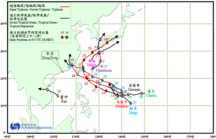
Seven tropical cyclones occurred over the western North Pacific and the South China Sea in September 2016, of which Meranti and Megi necessitated the issuance of tropical cyclone warning signals by the Observatory.
Namtheun formed as a tropical depression over the western North Pacific about 370 km south of Okinawa on the early morning of 1 September. It moved northeastwards and intensified rapidly that day. Namtheun turned northward the next day and developed into a severe typhoon, reaching its peak intensity with an estimated sustained wind of 165 km/h. Namtheun subsequently started to weaken and after skirting the west coast of Kyushu, Japan, degenerated into an area of low pressure over the Sea of Japan on 5 September.
According to press reports, Namtheun brought torrential rain and high winds to Kyushu. At least one person was injured and over 1 700 people were evacuated.
Malou formed as a tropical depression over the western North Pacific about 100 km west-northwest of Okinawa on the afternoon of 6 September and moved northeastwards. Malou reached its peak intensity that night with an estimated sustained wind of 55 km/h. Malou evolved into an extratropical cyclone over the seas south of Japan early in the morning on 8 September.
Meranti formed as a tropical depression over the western North Pacific about 390 km west of Guam on the early morning of 10 September. It moved west-northwestward and intensified rapidly. Meranti developed into a super typhoon on the night of 12 September and reached its peak intensity the next day with an estimated sustained wind of 250 km/h. After crossing the Luzon Strait on the night of 13 September, Meranti tracked northwestward and moved over the coastal waters of southwestern Taiwan the next day, heading towards Fujian and weakening gradually. Meranti made landfall near Xiamen on the early morning of 15 September and moved inland, before degenerating into an area of low pressure over Jiangxi early in the morning on 16 September.
According to press reports, at least two persons were killed and 63 were injured in Taiwan during the passage of Meranti. Electricity and water supply for over one million households were disrupted. Transportation services were paralyzed. Meranti also wreaked havoc in Fujian and Jiangxi, resulting in at least 29 deaths, 15 missing, and about 2.5 million people affected with the collapse of around 18 000 houses. Direct economic losses exceeded 11.7 billion RMB.
Rai formed as a tropical depression over the central part of the South China Sea about 500 km east-southeast of Da Nang on the morning of 12 September. It took on a west-northwesterly track towards the coast of Vietnam with an estimated sustained wind of 55 km/h near its centre at peak intensity. Rai made landfall over the central part of Vietnam on the early morning of 13 September and dissipated over Thailand that afternoon.
According to press reports, Rai brought torrential rain to Vietnam. At least two persons were killed and 33 people were injured. Many houses were damaged.
Malakas formed as a tropical depression over the western North Pacific about 470 km west of Guam on the night of 12 September. Taking a west-northwesterly to northwesterly track across the sea areas east of Luzon, it intensified gradually. Malakas developed into a severe typhoon on the early morning of 16 September and turned north-northwestwards across the seas east of Taiwan during the day. Malakas reached its peak intensity the next day with an estimated sustained wind of 175 km/h near its centre. It turned northeastwards on 18 September and swept across Japan on the night of 19 September and the next day, before evolving into an extratropical cyclone over southern Honshu during the night.
According to press reports, transportation services were affected in Taiwan during the passage of Malakas. Malakas also brought torrential rain and high winds to extensive areas in southern Japan, resulting in at least two deaths, one missing, 42 injuries and evacuation of about 300 000 people. Electricity supply for over 140 000 households in Kyushu was disrupted.
Megi formed as a tropical depression over the western North Pacific about 300 km south-southwest of Guam on the morning of 22 September. Moving generally northwestwards at first, it turned to the west-northwest the next day and intensified gradually. Megi developed into a severe typhoon over the sea areas east of Taiwan on the small hours of 26 September, reaching its peak intensity the next day with an estimated sustained wind of 175 km/h near its centre. Megi made landfall near Hualien in Taiwan and weakened on the afternoon of 27 September. After entering the Taiwan Strait, it continued to track west-northwestward in the general direction of Fujian. It made landfall again near Quanzhou on the morning of 28 September and moved inland across Fujian, before finally degenerating into an area of low pressure over Jiangxi early in the morning on 29 September.
According to press reports, Megi wreaked havoc in Taiwan, resulting in at least four deaths and over 500 injuries. Business and schools were suspended in all cities and transportation services were paralyzed. Agricultural damage was estimated to exceed NT$ 1 billion. Megi also brought torrential rain and ferocious winds to Fujian, Zhejiang and Jiangxi. At least six people were killed, 33 missing and over 600 000 people were evacuated. Direct economic losses exceeded 2.58 billion RMB.
Chaba formed as a tropical depression over the western North Pacific about 570 km east-northeast of Guam on the early morning of 28 September. Moving generally westward at first, it turned to the north-northwest on 30 September in the general direction of the Ryukyu Islands and intensified gradually.
 |
|---|
Tropical Cyclone Tracks in September 2016