Overview of Tropical Cyclones in August 2016
Overview of Tropical Cyclones in August 2016
Thursday, 8th September 2016
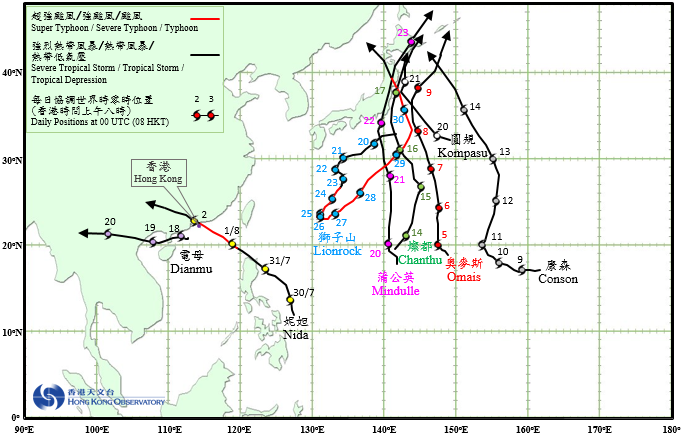
Eight tropical cyclones occurred over the western North Pacific and the South China Sea in August 2016, of which Nida and Dianmu necessitated the issuance of tropical cyclone warning signals by the Observatory.
Nida formed as a tropical depression over the western North Pacific about 750 km east-southeast of Manila on the night of 29 July and moved north-northwestwards at first. Nida then took on a northwesterly track towards the Luzon Strait on the afternoon of 30 July and intensified gradually. After developing into a severe tropical storm on the morning of 31 July, it swept across the north coast of Luzon in the afternoon and entered the northeastern part of the South China Sea that night. Taking on a west-northwesterly track towards the coast of Guangdong, it further intensified into a typhoon and reached its peak intensity on the afternoon of 1 August with an estimated sustained wind of 130 km/h near its centre. Nida made landfall near Dapeng Peninsula around 3 a.m. on 2 August and moved across Shenzhen, passing just to the north of Hong Kong. It started to weaken as it moved further inland, before finally degenerating into an area of low pressure over Guangxi early in the morning on 3 August.
According to press reports, about 500 000 people were affected and more than 300 houses collapsed in Guangdong, Guangxi, Hunan, Guizhou and Yunnan during the passage of Nida, with direct economic loss exceeding 500 million RMB. Business and schools were suspended in seven cities of Guangdong. Transportation services were paralyzed. Electricity supply to more than 16 000 households was affected in Shenzhen.
Omais formed as a tropical depression over the western North Pacific about 1 010 km southeast of Iwo Jima on the afternoon of 4 August. Tracking generally northwards, Omais intensified gradually and developed into a severe tropical storm on 6 August, reaching its peak intensity with an estimated sustained wind of 105 km/h near its centre. It continued to take a north-northwesterly track towards the sea areas east of Japan over the next two days and weakened gradually, before finally evolving into an extratropical cyclone early in the morning on 10 August.
Conson formed as a tropical depression over the western North Pacific about 580 km west-southwest of Wake Island on the afternoon of 8 August. Tracking west to west-northwestwards, Conson intensified gradually and developed into a tropical storm in the small hours on 9 August, reaching its peak intensity that night with an estimated sustained wind of 85 km/h near its centre. It started to move north-northeastwards on 11 August and turned north-northwestwards two days later, before finally evolving into an extratropical cyclone over the sea areas east of Japan on the night of 14 August.
Chanthu formed as a tropical depression over the western North Pacific about 580 km south of Iwo Jima in the small hours on 14 August. Moving north-northeastwards, it intensified into a tropical storm that morning. Chanthu reached its peak intensity with an estimated sustained wind of 85 km/h near its centre early in the morning on 15 August and turned north-northwestwards. It skirted past the east coast of northern Honshu, Japan on the morning of 17 August, before evolving into an extratropical cyclone over the sea areas south of Hokkaido that afternoon.
According to press reports, Chanthu brought torrential rain to the Tohoku region of Japan during its passage. Power supply to about 1 800 households was suspended, and transportation services were affected.
A tropical depression formed over the northern part of the South China Sea about 220 km southwest of Hong Kong on 17 August. It moved slowly and intensified gradually that day. The tropical depression intensified into a tropical storm and was named Dianmu the next morning. Moving generally westwards, Dianmu made landfall over Leizhou Peninsula on the afternoon of 18 August and entered Beibu Wan that night. It re-intensified as it moved across Beibu Wan, reaching its peak intensity with an estimated sustained wind of 85 km/h on the morning of 19 August. After making landfall over the northern part of Vietnam in the afternoon, Dianmu moved inland and weakened gradually. It finally degenerated into an area of low pressure over the northern part of Myanmar on the morning of 20 August.
According to press reports, there was flooding in many places in Hainan Island due to rainstorms brought by Dianmu. Around 40 000 people were evacuated and transportation services were affected. In Vietnam, a least 16 persons were killed, two were reported missing and another 15 were injured during the passage of Dianmu.
Meanwhile, three tropical depressions formed in quick succession over the western North Pacific on 19 – 20 August: Mindulle about 780 km south of Iwo Jima on the afternoon of 19 August, followed by Lionrock about 350 km south-southeast of Tokyo and Kompasu about 950 km east-southeast of Tokyo that night. Kompasu tracked northwestwards and intensified into a tropical storm on the morning of 20 August, reaching its peak intensity with an estimated sustained wind of 65 km/h near its centre. Kompasu turned northwards on 21 August off the east coast of northern Honshu, Japan and evolved into an extratropical cyclone that night over the east coast of Hokkaido.
According to press reports, at least one person was killed and three were injured in Hokkaido during the passage of Kompasu. Over 130 houses were flooded.
Tracking generally northwards after formation, Mindulle intensified into a tropical storm on the morning of 20 August and developed further into a severe tropical storm the next day, reaching its peak intensity on the morning of 22 August with an estimated sustained wind of 110 km/h near its centre. Mindulle made landfall east of Tokyo that day and swept across northern Honshu along a north-northeastward track. It finally evolved into an extratropical cyclone over the sea areas north of Hokkaido on 23 August.
Mindulle was the third tropical cyclone to strike eastern Japan in less than a week. According to press reports, Mindulle brought squalls and heavy rain to Honshu and Hokkaido during its passage. At least two persons were killed and over 60 were injured. Transportation services were affected.
But the sixth and most destructive cyclone to hit eastern Japan in a stormy August was yet to come. Though forming closest to Japan among its contemporaries, Lionrock initially tracked generally southwestwards away from Honshu due to its interaction with Kompasu and Mindulle. It started to slow down on the morning of 21 August and after drifting southeastwards for a while, it resumed a southwestward track on 23 August. Lingering for days over the sea areas east of the Ryukyu Islands, Lionrock continued to intensify and became a severe typhoon on the night of 24 August, reaching its peak intensity with an estimated sustained wind of 175 km/h near its centre early next day. Making a sharp U-turn, it started to track northeastwards on 26 August and headed back towards where it came from. After weakening into a typhoon on the afternoon of 29 August, Lionrock turned to the north-northwest heading straight towards northern Honshu. It swept across the Tohoku region the next day before evolving into an extratropical cyclone over the Sea of Japan on the morning of 31 August.
According to press reports, at least 12 people were killed, another five were reported missing and around 180 000 people had to be evacuated in the Tohoku region and Hokkaido during the passage of Lionrock. There were extensive flooding and landslides, and many houses were damaged. Transportation services were paralyzed.
 |
|---|
Tropical Cyclone Tracks in August 2016