Overview of Tropical Cyclones in July 2016
Overview of Tropical Cyclones in July 2016
Thursday, 11th August 2016
Four tropical cyclones occurred over the western North Pacific and the South China Sea in July 2016, of which Mirinae and Nida necessitated the issuance of the tropical cyclone warning signals by the Observatory.
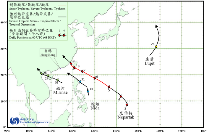
Nepartak formed as a tropical depression over the western North Pacific about 560 km south of Guam on 3 July. It moved northwest to west-northwestwards and intensified gradually. Nepartak developed into a super typhoon in the small hours of 6 July and reached its peak intensity with an estimated sustained wind of 230 km/h near its centre in the afternoon. After crossing the southern part of Taiwan on 8 July, Nepartak weakened into a typhoon. It continued to weaken as it entered the Taiwan Strait. Nepartak made landfall over the coast of Fujian on the afternoon of 9 July, and finally dissipated over inland Fujian on the morning of 10 July.
According to press reports, at least five people were killed and more than 400 injured in Taiwan during the passage of Nepartak. Nepartak and its remnant also brought severe damage to Fujian, Jiangxi and Guangdong. At least 69 people were killed and around 800 000 people affected, with direct economic loss exceeding 8 billion RMB.
Lupit formed as a tropical depression over the western North Pacific about 1 430 km east-northeast of Iwo Jima on the night of 23 July and tracked generally north-northeastwards. It intensified into a tropical storm the next day, reaching its peak intensity with an estimated sustained wind of 75 km/h near its centre. Lupit then turned north to north-northwestwards and finally transformed into an extratropical cyclone over the sea areas east of Japan in the small hours of 25 July.
Mirinae formed as a tropical depression over the central part of the South China Sea about 300 km east of Xisha on the night of 25 July. Moving west-northwestwards, it intensified into a tropical storm the next morning. Mirinae made landfall over the east coast of Hainan Island on the night of 26 July and weakened slightly while crossing Hainan Island. After entering Beibu Wan, Mirinae re-organized and re-intensified the next morning, becoming a severe tropical storm on the evening of 27 July and reaching peak intensity with an estimated sustained wind of 90 km/h near its centre. Mirinae made landfall over the coast of northern Vietnam that night and weakened gradually. It finally dissipated over northern Vietnam on the evening of 28 July.
According to press reports, at least one person was killed, five were injured and many houses collapsed during the passage of Mirinae in Vietnam.
Nida formed as a tropical depression over the western North Pacific about 750 km east-southeast of Manila on the night of 29 July and moved north-northwestwards at first. Nida then took on a northwesterly track towards the Luzon Strait on the afternoon of 30 July and continued to intensify. After developing into a severe tropical storm on the morning of 31 July, it swept across the north coast of Luzon in the afternoon and entered the northeastern part of the South China Sea that night.
 |
|---|
Tropical Cyclone Tracks in July 2016