Overview of Tropical Cyclones in October 2015
Overview of Tropical Cyclones in October 2015
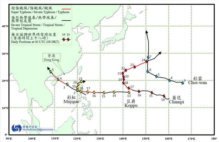
Four tropical cyclones occurred over the western North Pacific and the South China Sea in October 2015, with Severe Typhoon Mujigae necessitating the issuance of tropical cyclone warning signals in Hong Kong.
Mujigae formed as a tropical depression over the sea areas east of the Philippines about 290 km east of Manila on the afternoon of 1 October and tracked west-northwestwards in the direction of Luzon. Mujigae entered the South China Sea the next morning and intensified into a tropical storm. Moving west-northwestwards steadily, it edged closer to western Guangdong and continued to intensify in the next two days. Mujigae developed into a severe typhoon in the small hours of 4 October, reaching its peak intensity before noon with an estimated sustained wind of 175 km/h near its centre. It made landfall near Zhanjiang in Guangdong that afternoon and weakened gradually. Mujigae finally degenerated into an area of low pressure on the afternoon of 5 October over Guangxi.
According to press reports, at least 4.6 million people were affected and 8 500 houses were damaged in Guangdong and Guangxi during the passage of Mujigae, with direct economic loss amounting to over 12 billion RMB. Under the influence of the circulation of Mujigae, Shunde district in Foshan and Panyu district in Guangzhou were affected by tornadoes, resulting in at least six deaths and over 200 injuries. Houses were damaged and vehicles were overturned.
Choi-wan formed as a tropical depression over the western North Pacific about 2 690 km east of Iwo Jima on the night of 2 October. It moved west-northwestwards and intensified gradually. Choi-wan developed into a severe tropical storm on the afternoon of 5 October. Turning northwards the next day, it reached its peak intensity with an estimated sustained wind of 110 km/h near its centre. Choi-wan finally evolved into an extratropical cyclone over the western North Pacific east of Japan on the early morning of 8 October.
Koppu formed as a tropical depression over the western North Pacific about 2 320 km east of Manila on the morning of 13 October. It moved westwards and intensified gradually. Koppu developed into a super typhoon on the afternoon of 17 October and reached its peak intensity that night with an estimated sustained wind of 205 km/h near its centre. Koppu moved across Luzon on 18 October and weakened into a typhoon. It moved slowly northwards along the western coast of Luzon in the next two days and continued to weaken. Koppu finally degenerated into an area of low pressure near the Luzon Strait on 21 October.
According to press reports, Koppu brought torrential rain and flood to the northern part of the Philippines during its passage. At least 16 people were killed and more than 180 000 people had to be evacuated.
Champi formed as a tropical depression over the western North Pacific about 1 670 km east of Guam on the afternoon of 13 October. It moved generally west-northwestwards and intensified gradually. Champi developed into a typhoon on 16 October and gradually took on a northward course towards the vicinity of Iwo Jima. It further intensified into a super typhoon on the night of 18 October, reaching its peak intensity with an estimated sustained wind of 195 km/h near its centre. Champi slightly weakened into a typhoon in the next three days and started to turn east-northeastwards. It intensified again into a severe typhoon and skirted past the seas south of Iwo Jima on 22 October. Champi then speeded up on an east-northeasterly track and weakened gradually, before finally evolved into an extratropical cyclone over the western North Pacific east-northeast of Iwo Jima on the morning of 25 October.
 |
|---|
Tropical cyclone tracks in October 2015