Overview of Tropical Cyclones in September 2015
Overview of Tropical Cyclones in September 2015
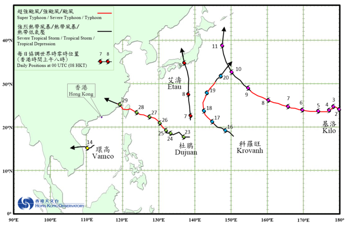
Five tropical cyclones occurred over the western North Pacific and the South China Sea in September 2015.
Kilo originated from the central North Pacific and crossed the International Date Line into the western North Pacific as a severe typhoon with an estimated sustained wind of 155 km/h near its centre on 2 September. Kilo subsequently weakened slightly into a typhoon and moved generally west-northwestwards. Kilo weakened further into a severe tropical storm on 9 September and started to track northwestwards. It finally evolved into an extratropical cyclone over the sea areas east of Japan in the early morning of 11 September.
Etau formed as a tropical depression over the western North Pacific about 440 km southwest of Iwo Jima on the morning of 7 September. It moved northwards towards the seas south of Japan and intensified gradually. Etau developed into a severe tropical storm on the morning of 8 September and reached its peak intensity with an estimated sustained wind of 90 km/h near its centre. It moved across Honshu, Japan on the morning of 9 September and weakened gradually. Etau finally evolved into an extratropical cyclone over the Sea of Japan that afternoon.
According to press reports, Etau triggered heavy rain and flooding in Japan during its passage. At least three persons were killed, 26 were missing, about 30 were injured and over 100 000 people had to be evacuated.
Vamco formed as a tropical depression over the central part of the South China Sea about 120 km south of Xisha on the afternoon of 13 September and tracked generally westwards. It reached its peak intensity on the morning of 14 September with an estimated sustained wind of 55 km/h near its centre. Vamco made landfall over the coast of central Vietnam that night and degenerated into an area of low pressure over Lao PDR early next morning.
Krovanh formed as a tropical depression over the western North Pacific about 1 230 km southeast of Iwo Jima on the afternoon of 15 September. It tracked northwestwards and intensified gradually, becoming a severe typhoon and reaching its peak intensity on the morning of 17 September with an estimated sustained wind of 165 km/h near its centre. Krovanh moved northwards and skirted past the sea areas east of Iwo Jima on 18 September. It then turned further to the northeast and weakened gradually, before finally evolving into an extratropical cyclone over the western North Pacific east of Japan in the early morning on 21 September.
Dujuan formed as a tropical depression over the western North Pacific about 1 940 east-southeast of Taibei on the morning of 23 September. It moved generally to the northwest or west-northwest towards Taiwan and intensified gradually. Dujuan developed into a super typhoon on 27 September, reaching its peak intensity with an estimated sustained wind of 210 km/h near its centre. It moved across Taiwan on the night of 28 September and weakened into a typhoon before making landfall over the coast of Fujian the next morning. Dujuan finally degenerated into an area of low pressure over Jiangxi in the early morning of 30 September.
According to press reports, Dujuan caused extensive damage in Taiwan, resulting in at least three deaths, over 300 injuries and more than 2.2 million households without electricity supply. There was widespread backflow of sea water along the coast of Xiamen. More than 400 000 people had to be evacuated in Fujian and Zhejiang during the passage of Dujuan.
 |
|---|
Tropical cyclone tracks in September 2015