Overview of Tropical Cyclones in August 2015
Overview of Tropical Cyclones in August 2015
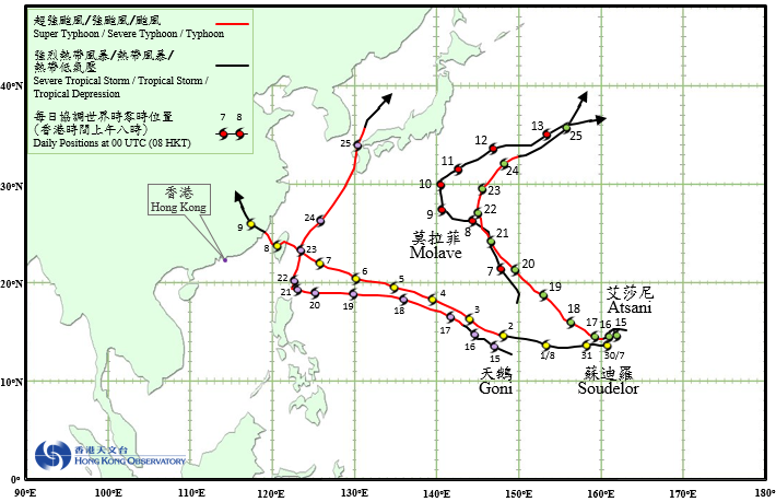
Four tropical cyclones occurred over the western North Pacific and South China Sea in August 2015.
Soudelor formed as a tropical depression over the western North Pacific about 1720 km east of Guam on the morning of 30 July. It moved west to west-northwestwards and intensified gradually in the next three days. Soudelor developed into a super typhoon on the afternoon of 3 August and reached its peak intensity the next morning with an estimated sustained wind of 240 km/h near its centre. It continued to track west-northwestwards towards Taiwan and gradually weakened into a severe typhoon in the next three days. After crossing Taiwan on the morning of 8 August, Soudelor weakened into a typhoon and made landfall over the coast of Fujian that night. It finally degenerated into an area of low pressure over Jiangxi on the morning of 10 August.
According to press reports, at least six persons were killed, four were missing and more than 4 million households were without power supply in Taiwan during the passage of Soudelor. In Fujian, Zhejiang, Jiangxi and Anhui, 21 people were killed, five were missing and about 3.4 million were affected in the fury of Soudelor.
Molave formed as a tropical depression over the western North Pacific about 2010 km south of Iwo Jima on the afternoon of 6 August and moved generally northwestwards. Molave intensified into a tropical storm on the night of 7 August and reached its peak intensity two days later with an estimated sustained wind of 85 km/h near its centre. It gradually turned to move in a northeast direction on 10 August and finally evolved into an extratropical cyclone over the western North Pacific east of Japan on the morning of 14 August.
Goni formed as a tropical depression over the western North Pacific about 470 km east of Guam on the afternoon of 14 August. Moving west to west-northwestwards, it intensified gradually in the next five days. Goni developed into a super typhoon on the night of 19 August, reaching its peak intensity with an estimated sustained wind of 195 km/h near its centre. Weakening into a severe typhoon, it started to turn northwards over Luzon Strait on the morning of 21 August and moved towards the seas east of Taiwan. Goni re-intensified into a super typhoon about 420 km west-southwest of Okinawa on the night of 23 August. It then turned to a northeasterly course, skirting past the vicinity of Ryukyu Islands and weakening gradually. Goni moved across Kyushu of Japan on 25 August and evolved into an extratropical cyclone over the Sea of Japan the next day.
According to press reports, during the passage of Goni, at least 26 people were killed and 15 were missing in the Philippines. Goni also wreaked havoc in Okinawa, resulting in at least eight death and over 200000 households without power supply. In Kyushu of Japan, at least 70 persons were injured, more than 600000 people had to be evacuated, near 500000 households were without power supply in the fury of Goni.
Atsani formed as a tropical depression over the western North Pacific about 2500 km east-southeast of Iwo Jima on the afternoon of 14 August. Moving slowly at first, Atsani intensified gradually. It started to take on a northwestly course on 17 August and developed into a super typhoon. Atsani reached its peak intensity on 19 August with an estimated sustained wind of 230 km/h near its centre. Skirting past the sea areas east of Iwo Jima on 21 August, Atsani started to turn northeastwards and weakened gradually. It finally evolved into an extratropical cyclone over the western North Pacific east of Japan on 25 August.
 |
|---|
Tropical cyclone tracks in August 2015