Overview of Tropical Cyclones in July 2015
Overview of Tropical Cyclones in July 2015
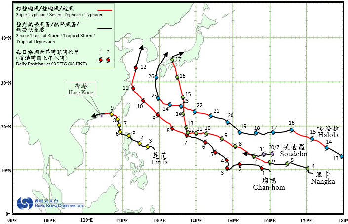
Five tropical cyclones occurred over the western North Pacific and South China Sea in July 2015, with Typhoon Linfa necessitating the issuance of tropical cyclone warning signals in Hong Kong.
Chan-hom formed as a tropical depression over the western North Pacific about 1 710 km east-southeast of Guam on the night of 30 June. It developed into a tropical storm the following morning and moved westwards. Under the influence of an area of low pressure west of Chan-hom, Chan-hom moved erratically on 2 - 3 July. It subsequently tracked generally northwestwards and intensified gradually, sweeping across the Ryukyu Islands and developing into a super typhoon on 10 July with a peak intensity of estimated sustained winds up to 195 km/h near its centre. Turning northwards the next day, Chan-hom skirted past the coast of Zhejiang and weakened gradually. Chan-hom finally evolved into an extratropical cyclone near the west coast of the Korea Peninsula on 12 July.
According to press reports, at least one person was killed and about two million people were affected in Zhejiang during the passage of Chan-hom, with direct economic loss estimated to be around RMB 6 billion. In Okinawa, at least 27 people were injured and more than 40 000 households were without power supply.
Linfa formed as a tropical depression over the western North Pacific about 830 km east of Manila on the afternoon of 2 July. It moved generally westwards and intensified into a tropical storm the next morning. Moving northwestwards, Linfa headed towards the northern part of Luzon and developed into a severe tropical storm on 4 July. Linfa moved across the northern part of Luzon on 5 July and entered the South China Sea. It weakened into a tropical storm the next day. With a weaker steering flow, Linfa drifted northwards slowly on 6 - 7 July and re-intensified into a severe tropical storm. It started to take on a more westerly track and edged closer to the coast of eastern Guangdong on the afternoon of 8 July. Linfa intensified into a typhoon that night, reaching its peak intensity the next morning with an estimated sustained wind of 130 km/h near its centre. It made landfall near Lufeng in Guangdong around noon and continued to track westwards across the coastal areas of Guangdong towards the Pearl River Estuary in the afternoon. Affected by relatively dry air from the north, Linfa weakened rapidly into a tropical depression. It finally degenerated into an area of low pressure over western Guangdong about 200 km west of Hong Kong on the morning of 10 July.
According to press reports, at least 700 000 people were affected and 6 700 houses were damaged in eastern Guangdong during the passage of Linfa. Transportation services were suspended and there was power outage in many places.
Nangka formed as a tropical depression over the western North Pacific about 240 km north of Marshall Islands on the night of 3 July. It moved generally west to west-northwestwards and intensified gradually. Nangka developed into a super typhoon on the night of 7 July and reached its peak intensity two days later with an estimated sustained winds of 220 km/h near its centre. Nangka weakened into a typhoon on 12 July and started to turn north towards the sea areas south of Japan. It re-intensified into a severe typhoon on 14 July and weakened gradually the following day. Nangka moved across the western part of Japan on 16 July and evolved into an extratropical cyclone over the Sea of Japan during the night.
According to press reports, Nangka left at least five people dead and several dozen injured in Japan.
Originating from the central part of the North Pacific, Severe Tropical Storm Halola crossed the International Date Line and entered the western North Pacific on 13 July. Moving generally west-northwestwards, it intensified into a typhoon the next day. Halola started to weaken afterwards and took on a more westerly track, at one stage degenerating into a tropical depression on 18 July. Halola resumed a west-northwesterly track the next day and re-intensified, developing into a severe typhoon on the morning of 23 July and reaching peak intensity with an estimated sustained wind of 155 km/h near its centre. Turning northwards on 25 July, Halola skirted past the Ryukyu Islands and weakened gradually. It finally degenerated into an area of low pressure near Kyushu, Japan on 26 July.
According to press reports, heavy rain brought by Halola flooded many houses and triggered landslides on the island of Amami Oshima in the northern part of the Ryukyu Islands and over the southwestern part of Japan.
Soudelor formed as a tropical depression over the western North Pacific about 1 710 km east of Guam on the morning of 30 July. It moved generally westwards and gradually intensified.
 |
|---|
Tropical cyclone tracks in June 2015