|
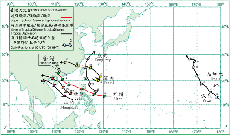
Seven tropical cyclones occurred over the western North Pacific and the South China Sea in August 2013. Amongst them, Jebi and Utor necessitated the issuance of tropical cyclone warning signals by the Hong Kong Observatory during the month.
Jebi formed as a tropical depression over the central part of the South China Sea about 450 km east-southeast of Xisha on 31 July. Moving west-northwestwards, Jebi intensified into a tropical storm that afternoon. It took on a northwesterly track the next day across the seas near Xisha. Jebi intensified into a severe tropical storm in the morning on 2 August to the north-northeast of Xisha, reaching its peak intensity with estimated sustained winds of 105 km/h near its centre that afternoon. It made landfall over the northeastern tip of Hainan Island that evening, then turned to move west-northwestwards across the island that night. Jebi moved across Beibu Wan in the small hours on 3 August and made landfall over the coast of northern Vietnam that morning. It weakened into a tropical storm in the afternoon and dissipated over the northern part of Vietnam during the night.
Mangkhut formed as a tropical depression over the central part of the South China Sea about 720 km southeast of Xisha on 5 August and moved to the west-northwest or northwest, intensifying into a tropical storm southwest of Xisha the next day. It reached its peak intensity with estimated sustained winds of 75 km/h and skirted the southwestern coast of Hainan on 7 August, making landfall over the coast of northern Vietnam that night. Mangkhut dissipated over the northern part of Laos the next day. According to press reports, at least three people were killed, 14 houses collapsed and over 700 houses damaged in Vietnam during the passage of Mangkhut.
Utor formed as a tropical depression over the western North Pacific about 1 350 km east of Manila on 9 August and moved westwards initially. It took on a west-northwesterly track and gradually became a typhoon the next day. Utor continued to strengthen on 11 August and became a super typhoon about 290 km east-northeast of Manila in the evening, reaching its peak intensity with estimated sustained winds of 195 km/h near its centre. It crossed Luzon and weakened into a severe typhoon in the small hours on 12 August, entering the South China Sea in the morning and turning to move northwestwards over the northern part of the South China Sea to the south of Hong Kong the next day. It weakened into a typhoon and made landfall near Yangjiang in the afternoon on 14 August, moving west-northwestwards across the coast of western Guangdong in the evening and weakening into a severe tropical storm that night. Utor took on a northerly track across Guangxi and weakened gradually into a tropical depression the next day. It finally dissipated over the inland areas of Guangxi on 16 August.
Trami formed as a tropical depression over the sea areas about 550 km east-southeast of Gaoxiong, Taiwan on 17 August and moved eastwards slowly. It gradually intensified into a severe tropical storm over the next couple of days. Trami gradually turned to move northwestwards on 20 August. It intensifed further into a typhoon the next day, reaching its peak intensity with estimated sustained winds of 120 km/h near its centre, crossing the sea areas north of Taiwan at night. Trami made landfall over the coast of Fujian in the small hours of 22 August and gradually weakened into a tropical storm during the day, dissipating over Hunan the next day. Trami caused flooding in Taiwan during its passage, where three people were killed and 11 others injured. Trami also brought rainstorms to Fujian, Shantou and Hunan, where at least eight people were killed, six people missing and over 30 people injured. Moreover, more than 300 fishing boats sank in Fujian during the passage of Trami, with direct economic loss of around 2,100 million RMB reported.
Having formed over the central part of the North Pacific, Severe Tropical Storm Pewa crossed the International Date Line and entered the western North Pacific on a northwesterly track on 18 August. Pewa reached its peak intensity with estimated sustained winds of 100 km/h near its centre the next day. It weakened into a tropical storm to the east-southeast of Wake Island on 20 August, and took on a north-northwesterly track the next day. Pewa became slow moving on 23 August and finally dissipated over the western North Pacific to the north of Wake Island two days later.
Also coming from the central part of the North Pacific, Tropical Storm Unala crossed the International Date Line and entered the western North Pacific on 19 August, with estimated sustained winds of 65 km/h near its centre. Unala moved west-southwestwards and dissipated over the sea that night.
Kong-rey formed as a tropical depression over the western North Pacific about 640 km east-northeast of Manila on 26 August. Moving northwestwards, it intensified into a tropical storm that afternoon. It turned north-northwestwards the next day, and intensified into a severe tropical storm while moving northwards across the seas east of Taiwan on 28 August. It reached its peak intensity with estimated sustained winds of 105 km/h near its centre the next day, before soon weakening into a tropical storm in the evening. Kong-rey turned to move northeastwards over the East China Sea on 30 August and became an extratropical cyclone that night. In Taiwan, a fisherman was reported missing during the passage of Kong-rey.
|
