|
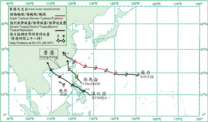
Four tropical cyclones occurred over the western North Pacific and the South China Sea in July 2013. Amongst them, Rumbia and Cimaron necessitated the issuance of tropical cyclone warning signals by the Hong Kong Observatory during the month.
Rumbia formed as a tropical depression over the western North Pacific about 990 km east-southeast of Manila on 28 June and moved west-northwest to northwestward. It intensified into a tropical storm and moved across the central Philippines the next day. Rumbia entered the central part of the South China Sea on 30 June and intensified further into a severe tropical storm over the northern part of the South China Sea the next morning, reaching its peak intensity with estimated sustained winds of 105 km/h near its centre. It turned northwestward over the seas east of Hainan Island that night and made landfall near Zhanjiang in the morning on 2 July. Rumbia then moved across Guangxi and weakened into a tropical storm before dissipating over the inland areas that night.
Soulik formed as a tropical depression over the western North Pacific about 890 km northeast of Guam on 7 July and moved westward. It gradually intensified and became a typhoon about 830 km northwest of Guam on 9 July. Moving west-northwestward, Soulik intensified further into a super typhoon on 10 July, reaching its peak intensity with estimated sustained winds of 205 km/h near its centre. It weakened into a severe typhoon the next day and crossed the seas east of Taiwan. Soulik swept past northern Taiwan and weakened into a typhoon in the morning on 13 July. After crossing the Taiwan Strait, it made landfall over the coast of Fujian that afternoon and weakened into a severe tropical storm in the evening. Soulik weakened further into a tropical storm in the early hours on 14 July and dissipated over Jiangxi that day. According to press reports, three people were killed, over 120 people were injured and electricity supply to more than 1,140,000 households were interrupted in Taiwan during the passage of Soulik. In addition, some 990 houses collapsed in Fujian. The total direct economic loss in Fujian, Zhejiang and Jiangxi exceeded 2 billion RMB.
Cimaron formed as a tropical depression over the western North Pacific about 390 km east-northeast of Manila on 16 July and moved northwestward. After skirting the northeastern tip of Luzon on 17 July, it moved across the Luzon Strait and intensified into a tropical storm, reaching its peak intensity with an estimated sustained wind of 65 km/h near its centre. Cimaron entered the northeastern part of the South China Sea in the early hours on 18 July. It turned northward in the morning and made landfall over the coast of Fujian that evening. Cimaron weakened into a tropical depression over Fujian in the early hours on 19 July and subsequently dissipated inland.
Jebi formed as a tropical depression over the central part of the South China Sea about 450 km east-southeast of Xisha in the morning on 31 July. It intensified into a tropical storm that afternoon, moving west-northwestward in the general direction of Hainan Island.
|
