|
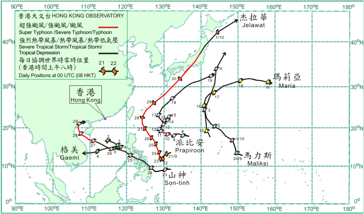
Six tropical cyclones occurred over the western North Pacific and South China Sea in October 2012.
After forming over the western North Pacific about 1 160 km east of Manila on 21 September, Jelawat strengthened gradually and became a super typhoon on 23 September, reaching its peak intensity with an estimated maximum sustained wind of 220 km/h near its centre over the Pacific to the east of Manila on 25 September. It made landfall over southern Honshu, Japan on 30 September and moved across the island. Jelawat weakened into a severe tropical storm on 1 October and moved across the seas to the east of Hokkaido. Jelawat became an extratropical cyclone over the western North Pacific near Kuril Islands that evening.
Maliksi formed as a tropical depression over the western North Pacific about 670 km east of Guam on 29 September and moved west-northwestwards. It turned to move northwards across the western North Pacific on the following day. Maliksi took up a northwesterly track on 1 October and intensified into a tropical storm. While passing close to Iwo Jima on 3 October, Maliksi turned to move north-northeastwards and intensified into a severe tropical storm, reaching its peak intensity with an estimated maximum sustained wind of 90 km/h near its centre. Maliksi became an extratropical cyclone over the western Pacific to the east of Japan on 4 October.
Gaemi formed as a tropical depression over the central part of the South China Sea about 260 km east-southeast of Xisha on 1 October and was slow-moving initially. It started to move east-southeastwards on 2 October and intensified into a tropical storm. Gaemi slowed down and intensified further into a severe tropical storm on 3 October, reaching its peak intensity with an estimated maximum sustained wind of 90 km/h near its centre. It turned to move west to west-southwestwards across the central part of the South China Sea on 4 October and weakened into a tropical storm. Gaemi passed to the south of Xisha on 6 October, made landfall over the coast of central Vietnam in the evening and dissipated over inland Vietnam. According to press reports, one person was injured, around 30 houses and schools were damaged in central Vietnam during the passage of Gaemi.
Prapiroon formed as a tropical depression over the western North Pacific about 1 710 km east-northeast of Manila on 7 October and moved slowly west to west-northwestwards. Prapiroon intensified gradually into a severe tropical storm on 8 October and continued to strengthen into a typhoon on 9 October. It intensified further into a severe typhoon about 880 km south-southeast of Okinawa on 10 October, reaching its peak intensity the following day with an estimated maximum sustained wind of 165 km/h near its centre. Prapiroon lingered over the seas to the southeast of Ryukyu Islands from 11 October to 15 October, during which it weakened into a typhoon. It adopted a north-northwesterly track on 16 October and weakened into a severe tropical storm. It speeded up towards the northeast on 17 October, passing about 230 km southeast of Okinawa that evening and weakened into a tropical storm on 18 October. Prapiroon became an extratropical cyclone over the western North Pacific to the southeast of Japan on 19 October. Heavy rain brought about by Prapiroon triggered landslides on the island of Amami Oshima in the northern part of the Ryukyu Islands, leaving more than 1 200 households without power there.
Maria formed as a tropical depression over the western North Pacific about 790 km south of Iwo Jima on 14 October and moved north-northwestwards. It intensified into a tropical storm on 15 October and turned to move northwards. Maria intensified further into a severe tropical storm to the southwest of Iwo Jima on 16 October, reaching its peak intensity with an estimated maximum sustained wind of 90 km/h near its centre and turned to move northeastwards subsequently. It moved east-northeastwards on 17 October and weakened into a tropical storm on the following day. Maria became an extratropical cyclone over the western North Pacific near 160 ?E on 19 October.
Son-tinh formed as a tropical depression over the western North Pacific about 1 310 km east-southeast of Manila on 22 October and moved westwards. It took up a west-northwesterly track on 24 October, crossed the central Philippines and intensified into a tropical storm. Son-tinh entered the central part of the South China Sea on 25 October and intensified into a severe tropical storm on the following day. It moved across the central part of the South China Sea and continued to strengthen, became a severe typhoon over the seas south of Hainan Island on 27 October, reaching its peak intensity with an estimated maximum sustained wind of 155 km/h near its centre. Son-tinh weakened into a typhoon over Beibu Wan on the following day and adopted a north-northwesterly track. It made landfall over the coast of northern Vietnam, then turned to drift eastwards on 29 October, and finally dissipated over Bei Bu Wan the next day. In the fury of Son-tinh, around 27 people were killed in the Philippines. On Hainan Island, at least one person was killed and five missing during the passage of Son-tinh. In addition, over 2 700 houses collapsed or were damaged, some 41 000 hectares of farmland inundated and the direct economic loss estimated to exceed 900 million RMB.
|
