|
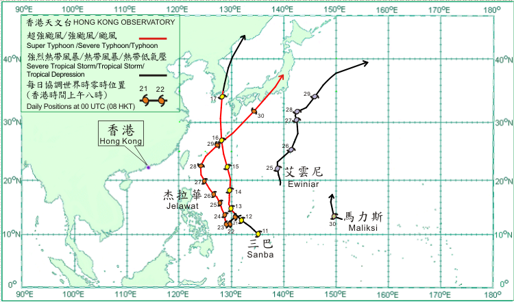
Four tropical cyclones occurred over the western North Pacific but none over the South China Sea in September 2012.
Sanba formed as a tropical depression over the western North Pacific about 1 660 km east-southeast of Manila on 11 September. Moving northwestwards, Sanba intensified into a tropical storm that afternoon and a severe tropical storm on 12 September. Sanba intensified into a typhoon over the western North Pacific to the east of Manila in the morning on 13 September and turned to move northwards. It continued to strengthen and became a super typhoon that evening. Sanba reached its peak intensity with an estimated maximum sustained wind of 220 km/h near its centre over the Pacific to the east of Luzon on 14 September. It passed close to Okinawa in the morning on 16 September and subsequently moved across the East China Sea and weakened into a severe typhoon. Sanba made landfall over the Republic of Korea on 17 September and weakened gradually into a severe tropical storm. It moved north-northeastwards across the eastern part of the Republic of Korea that day, subsequently moved across the Sea of Japan and weakened into a tropical storm that evening. Sanba became an extratropical cyclone over the coastal areas of Russia on 18 September. According to press reports, the outer rainbands of Sanba affected the Philippines where one person was killed. A freighter capsized over the waters near Taiwan. Sixteen people on board were rescued and another person missing. Over 60 000 households were left without electricity in Okinawa during the passage of Sanba. In the southwestern part of Japan, one person was killed, four injured and another person missing. One person was killed, one missing and electricity supply to 450 000 households were interrupted in the Republic of Korea.
Jelawat formed as a tropical depression over the western North Pacific about 1 160 km east of Manila on 21 September. Moving slowly southwestwards, it intensified into a tropical storm that afternoon. Jelawat intensified into a severe tropical storm on 22 September. It strengthened significantly into a super typhoon over the seas east of the central Philippines on 23 September and turned to move north-northwest to northwestwards. Jelawat reached its peak intensity with an estimated maximum sustained wind of 220 km/h near its centre over the Pacific to the east of Manila on 25 September. It turned to move northwards over the seas to the southeast of Taiwan on 27 September, and further to move northeastwards on 28 September and weakened into a severe typhoon. Jelawat passed close to Okinawa on 29 September. On 30 September, Jelawat first weakened into a typhoon over the seas south of Japan, subsequently making landfall over southern Honshu, Japan, and moved across Honshu. In the fury of Jelawat, at least 80 people were injured, over 330 000 households were left without electricity and many vehicles were overturned in Okinawa. At least two people were killed and over 100 people were injured in other areas in Japan during the passage of Jelawat.
Ewiniar formed as a tropical depression over the western North Pacific about 680 km south-southwest of Iwo Jima on 24 September and moved generally northwards. It intensified into a tropical storm on 25 September and turned to move northeastwards. Ewiniar took up a north to north-northeasterly track over the western North Pacific near Ogasawara Islands for the following two days. It intensified into a severe tropical storm near the Ogasawara Islands on 26 September, reaching its peak intensity with an estimated maximum sustained wind of 90 km/h near its centre. Ewiniar turned to move northeastwards on 28 September and weakened into a tropical storm on the following day. Ewiniar subsequently became an extratropical cyclone over the western North Pacific to the east of Japan on 30 September.
Maliksi formed as a tropical depression over the western North Pacific about 670 km east of Guam on 29 September and moved west-northwestwards. It turned to move northwards across the western North Pacific on the following day.
|

