|
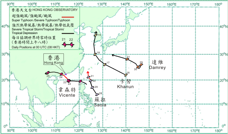
Four tropical cyclones occurred over the western North Pacific and South China Sea in July 2012. Amongst them, Vicente necessitated the issuance of tropical cyclone warning signals in Hong Kong.
Khanun formed as a tropical depression over the western North Pacific about 340 km south-southwest of Iwo Jima on 16 July. Moving west-northwest to northwestwards, it intensified into a tropical storm that evening and moved across the seas near Ryukyu Islands on the following day. Khanun intensified into a severe tropical storm over the East China Sea on the morning of 18 July and turned to move northwards, reaching its peak intensity with an estimated maximum sustained wind of 90 km/h near its centre. It weakened into a tropical storm that evening and subsequently moved across the Republic of Korea. Khanun dissipated over the Korean Peninsula on 19 July. According to press reports, one person was killed, several buildings were damaged and over 26 000 houses were left without electricity in the Republic of Korea during the passage of Khanun. At least seven people were killed in DPR Korea and storm surge was reported in some coastal areas.
Vicente formed as a tropical depression over the western North Pacific about 460 km northeast of Manila on 20 July. Moving west-northwestwards, it made its way over Luzon Strait that night and entered the northern part of the South China Sea on 21 July. Moving westwards, it intensified into a tropical storm that night and became almost stationary over the South China Sea on 22 July. Vicente began to edge towards the south China coast to the west of the Pearl River Estuary on 23 July and underwent rapid intensification to a typhoon in the afternoon and further to a severe typhoon around mid-night, reaching its peak intensity with an estimated maximum sustained wind of 155 km/h near its centre. Vicente made landfall near the coastal areas of Taishan about 130 km west-southwest of Hong Kong before dawn on 24 July and weakened into a typhoon. It subsequently moved generally west-northwestwards across western Guangdong and Guangxi and weakened gradually. Vicente dissipated over the northern part of Vietnam on 25 July.
Saola formed as a tropical depression over the western North Pacific about 700 km east of Manila on 28 July. Moving north-northwestwards, it intensified into a tropical storm that afternoon. Saola continued to intensify into a severe tropical storm on 29 July and further into a typhoon to the east of the Luzon Strait on the following day, with an estimated maximum sustained wind of 120 km/h near its centre. Saola moved north to north-northwestwards across the seas to the east of Taiwan on 31 July.
Damrey formed as a tropical depression over the western North Pacific about 530 km east of Iwo Jima on 28 July and was slow moving initially. It started to move generally west-northwestwards on 30 July and intensified into a tropical storm. Damrey strengthened further into a severe tropical storm over the western North Pacific to the south of Japan with an estimated maximum sustained wind of 105 km/h near its centre on 31 July and continued to move west-northwestwards towards the seas south of Kyushu.
|
