|
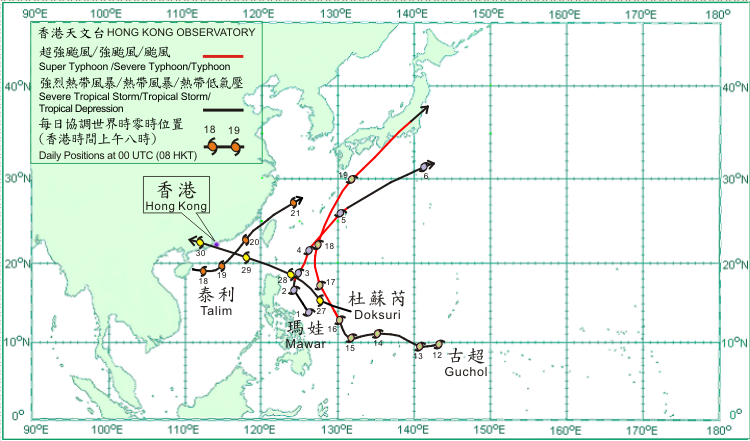
Four tropical cyclones occurred over the western North Pacific and South China Sea in June 2012. Amongst them, Talim and Doksuri necessitated the issuance of tropical cyclone warning signals in Hong Kong.
Mawar formed as a tropical depression over the western North Pacific about 560 km east of Manila on 1 June. Moving north-northwestwards, it intensified into a tropical storm that evening. Mawar intensified gradually into a typhoon on 2 June and turned to move north to north-northeastwards. On 4 June, Mawar reached its peak intensity over the Pacific to the south-southwest of Okinawa with an estimated maximum sustained wind of 145 km/h near its centre and move northeastwards. It weakened into a severe tropical storm on 5 June and became an extratropical cyclone over the western North Pacific to the southeast of Japan on 6 June.
Guchol formed as a tropical depression over the western North Pacific about 460 km south-southwest of Guam on 12 June. Moving west to west-northwestwards, it gradually strengthened into a tropical storm that afternoon and further into a severe tropical storm two days afterwards. Guchol turned to move north-northwestwards on 15 June. It continued to strengthen into a typhoon on the morning of 16 June and became a super typhoon that evening. Guchol reached its peak intensity over the Pacific to the east of Luzon on 17 June, with an estimated maximum sustained wind of 205 km/h near its centre. It moved north to north-northeastwards to the south of Okinawa on 18 June and started to weaken. Moving northeastwards, Guchol weakened into a typhoon on 19 June and crossed southeastern Japan that evening. It first weakened into a severe tropical storm and subsequently became an extratropical cyclone over the western North Pacific to the east of Japan on 20 June. According to press reports, at least one person was killed, one missing and some 70 people injured in Japan during the passage of Guchol. There were also interruptions of electricity supply to around 10 000 households.
Talim formed as a tropical depression over the northern part of the South China Sea to the east of Hainan Island on 17 June and moved slowly eastwards. It intensified into a tropical storm on the morning of 18 June and further into a severe tropical storm over the northern part of the South China Sea to the south of Hong Kong at night, reaching its peak intensity with an estimated maximum sustained wind of 90 km/h near its centre. Talim turned to move northeastwards across the northeastern part of the South China Sea on 19 June. It weakened into a tropical storm and moved across the Taiwan Strait on 20 June. Talim first weakened into a tropical depression and then dissipated over the East China Sea on 21 June.
Doksuri formed as a tropical depression over the western North Pacific about 1 150 km east of Manila on 26 June and moved west-northwestwards. It intensified into a tropical storm and moved northwestwards on the following day. Doksuri reached its peak intensity over the seas to the northeast of Luzon on 28 June with an estimated maximum sustained wind of 85 km/h near its centre. It moved west-northwestwards across the Luzon Strait during the day and entered the South China Sea that night. Doksuri moved across the northern part of the South China Sea on 29 June. It made landfall over the south China coast to the west of the Pearl River Estuary on the small hours of 30 June. Doksuri weakened into a tropical depression and subsequently dissipated inland over western Guangdong that morning.
|
