|
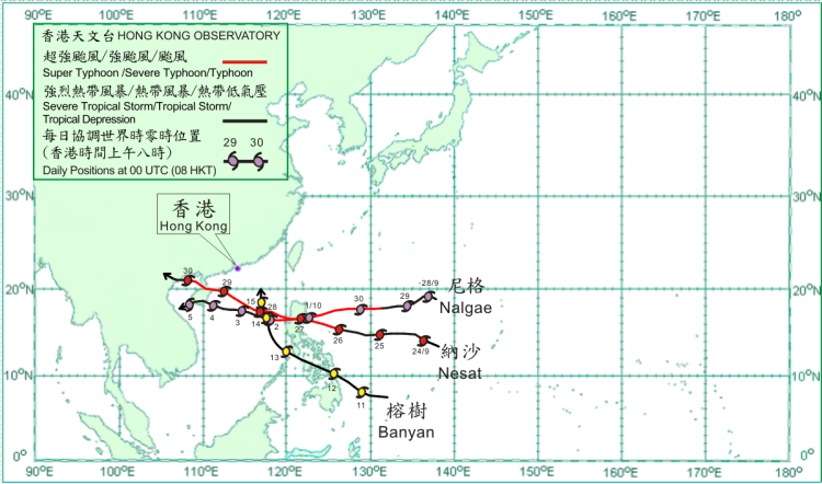
Three tropical cyclones occurred over the western North Pacific and South China Sea in October 2011. Amongst them, Nalgae necessitated the issuance of tropical cyclone warning signals in Hong Kong.
After forming over the western North Pacific about 1 840 km east of Manila on 23 September, Nesat moved towards Luzon and gradually intensified. Nesat became a typhoon over the ocean about 560 km east of Manila on 26 September, reaching its peak intensity with an estimated maximum sustained wind of 145 km/h near its centre. It then moved across Luzon, the northern part of the South China Sea and Hainan Island, and subsequently made landfall over the coast of northern Vietnam on 30 September. Nesat dissipated over northern Vietnam on 1 October.
After forming over the western North Pacific about 1 850 km east-northeast of Manila on 27 September, Nalgae moved towards Luzon and gradually intensified. It became a severe typhoon over the western North Pacific on the evening of 30 September. Nalgae attained its peak intensity with an estimated maximum sustained wind of 175 km/h near its centre over the seas about 300 km northeast of Manila on the morning of 1 October. Nalgae then crossed Luzon and entered the South China Sea in the late afternoon. It moved west to west-northwestwards across the northern part of the South China Sea for the following two days. Nalgae weakened into a typhoon in the early hours on 2 October and a severe tropical storm that afternoon. It weakened further into a tropical storm on 4 October and crossed the southern part of Hainan Island that afternoon, entering Beibu Wan and weakening further into a tropical depression at night. Nalgae moved southwestwards across the southern part of Beibu Wan on 5 October and dissipated over the seas near Hainan that day.
Banyan formed as a tropical depression over the western North Pacific about 1 300 km southeast of Manila on 10 October and moved west-northwestwards, reaching its peak intensity with an estimated maximum sustained wind of 55 km/h near its centre on the following day. It crossed the central part of the Philippines on 12 October and turned to move northwestwards across the central part of the South China Sea on the following day. Banyan moved north-northwestwards on 14 October and dissipated over the northern part of the South China Sea about 160 km south of Dongsha on 15 October.
|
