|
Eight tropical cyclones occurred over the western North Pacific and South China Sea in September 2011. Amongst them, Nesat necessitated the issuance of tropical cyclone warning signals in Hong Kong.
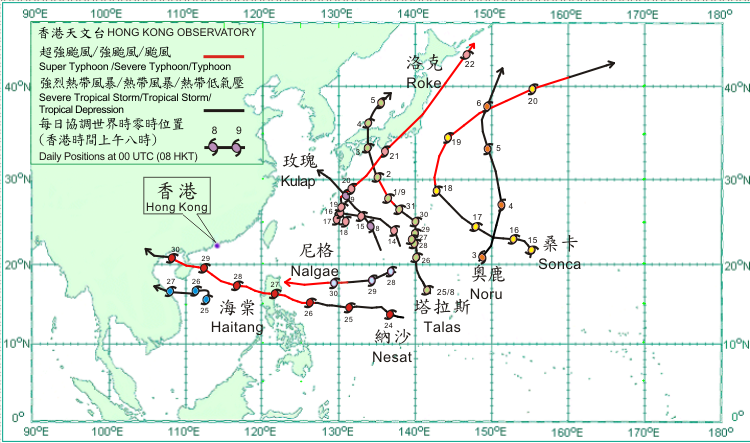
After forming over the western North Pacific about 480 km northwest of Guam on 24 August, Talas gradually intensified and moved in the general direction of Japan. On 1 September, Talas moved northwestwards and intensified into a typhoon to the south of Osaka, reaching its peak intensity with an estimated maximum sustained wind of 120 km/h near its centre. Talas weakened into a severe tropical storm over the seas south of Japan on 2 September and turned to move northwards across Shikoku and Honshu, Japan on 3 September. It entered the Sea of Japan on the following day and weakened into a tropical storm. Talas became an extratropical cyclone over the Sea of Japan on 5 September. According to press reports, torrential rain brought about by Talas triggered flooding and landslides in Japan, where at least 46 people were killed and some 50 people missing.
Noru formed as a tropical depression over the western North Pacific about 890 km east-southeast of Iwo Jima on 2 September and moved generally north-northeastwards. It turned to move north-northwestwards and intensified into a tropical storm to the east-northeast of Iwo Jima on 4 September, reaching its peak intensity with an estimated maximum sustained wind of 75 km/h near its centre. It then resumed moving north-northeastwards and became an extratropical cyclone over the western North Pacific to the east of Japan on 6 September.
Kulap formed as a tropical depression over the western North Pacific about 930 km east-southeast of Okinawa on 7 September and moved generally northwestwards. It intensified into a tropical storm that evening, reaching its peak intensity with an estimated maximum sustained wind of 65 km/h near its centre. Kulpa weakened into a tropical depression to the east-northeast of Okinawa on 9 September. It weakened further into an area of low pressure over the East China Sea southwest of Kyushu, Japan on 10 September.
Roke formed as a tropical depression over the western North Pacific about 1 140 km east-southeast of Okinawa on 13 September and moved north- northwestwards. It turned to move west-northwestwards the following day and intensified into a tropical storm on 15 September. Roke lingered near Okinawa for the following two days and intensified into a severe tropical storm. It took up a northward track on 18 September and intensified to a typhoon to the northeast of Okinawa on 19 September. Roke speeded up to move northeastwards on 20 September and intensified into a severe typhoon over the seas south of Japan, reaching its peak intensity with an estimated maximum sustained wind of 155 km/h near its centre. It crossed eastern Honshu, Japan and weakened into a typhoon on 21 September. Roke became an extratropical cyclone over the seas east of Hokkaido on 22 September. Roke brought torrential rain to many parts of Japan triggering landslides. At least 12 people were killed, another five missing and over 300 people injured in Japan.
Sonca formed as a tropical depression over the western North Pacific about 1 440 km east-southeast of Iwo Jima on 15 September. Moving generally northwestwards, Sonca intensified into a tropical storm that afternoon. Sonca intensified into a severe tropical storm on 17 September and further into a typhoon to the south-southeast of Tokyo on 18 September, reaching its peak intensity with an estimated maximum sustained wind of 130 km/h near its centre on 19 September. Sonca weakened into a severe tropical storm on 20 September and became an extratropical cyclone over the western North Pacific to the east of Japan that evening.
Nesat formed as a tropical depression over the western North Pacific about 1 840 km east of Manila on 23 September and moved west-northwestwards. It gradually intensified over the western North Pacific and became a typhoon about 560 km east of Manila on 26 September, reaching its peak intensity with an estimated maximum sustained wind of 145 km/h near its centre. On 27 September, Nesat crossed Luzon and entered the South China Sea in the afternoon. It moved across the northern part of the South China Sea for the following two days and made landfall over the northeastern part of Hainan Island on the afternoon of 29 September. On 30 September, Nesat first moved across Beibu Wan, then made landfall again over the coast of northern Vietnam in the afternoon and weakened gradually into a tropical storm. It then moved across northern Vietnam that evening.
Haitang formed as a tropical depression over the central part of the South China Sea about 140 km south of Xisha on 25 September and moved slowly. Haitang intensified into a tropical storm that afternoon, reaching its peak intensity with an estimated maximum sustained wind of 65 km/h near its centre. Haitang moved westwards across the seas south of Hainan on 26 September. It made landfall over the coast of Vietnam on 27 September and weakened into a tropical depression, dissipating over Indochina that evening. Four people were killed and another four missing in Vietnam during the passage of Haitang.
Nalgae formed as tropical depression over the western North Pacific about 1 760 km east-northeast of Manila on 28 September and moved west-southwestwards. It intensified into a tropical storm that afternoon. Nalgae intensified into a severe tropical storm and moved westwards on the following day. On 30 September, it gradually intensified into a severe typhoon with an estimated maximum sustained wind of 165 km/h near its centre about 600 km east-northeast of Manila and continued to move westwards towards Luzon.
|