|
Four tropical cyclones occurred over the western North Pacific and South China Sea in July 2011. Amongst them, Nock-ten necessitated the issuance of tropical cyclone warning signals in Hong Kong.
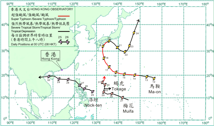
Ma-on formed as a tropical depression over the western North Pacific about 1 370 km east-northeast of Guam on 12 July and moved generally westwards. It gradually intensified and became a typhoon on 14 July and a severe typhoon on the following day. Ma-on intensified into a super typhoon over the western North Pacific to the east-southeast of Okinawa on 16 July, reaching its peak intensity with an estimated maximum sustained wind of 185 km/h near its centre. Ma-on moved northwestwards and weakened into a severe typhoon on 17 July, and turned to move northwards on 18 July. It weakened into a typhoon and turned to move northeastwards on 19 July, crossing the seas south of Shikoku, Japan. Ma-on made landfall over southern Honshu on 20 July and weakened into a severe tropical storm, but turned to move southeastwards across the seas south of Japan subsequently. It turned to move north-northeastwards on 22 July and weakened into a tropical storm on 23 July. Ma-on became an extratropical cyclone over the western North Pacific east of Japan on 24 July. At least one person was killed and 60 injured in Japan during the passage of Ma-on.
A tropical depression formed over the western North Pacific about 1 340 km east of Manila on 15 July and was named Tokage. The estimated maximum sustained wind near its centre was about 45 km/h. Moving eastwards, the tropical depression dissipated over the western North Pacific on 16 July.
Nock-ten formed as a tropical depression over the western North Pacific about 790 km east-southeast of Manila on 25 July and moved generally west-northwestwards. Nock-ten intensified into a tropical storm the next day. It turned to move northwestwards and intensified into a severe tropical storm on 27 July, crossing Luzon that afternoon. Nock-ten moved generally west to west-northwestwards across the northern part of the South China Sea for the following two days, reaching its peak intensity with an estimated maximum sustained wind of 105 km/h near its centre. It made landfall over Hainan Island on 29 July. Moving across Beibu Wan on 30 July, Nock-ten weakened into a tropical storm. It made landfall again over the coast of northern Vietnam that evening and subsequently dissipated inland over Laos on 31 July.
Muifa formed as a tropical depression over the western North Pacific about 500 km south of Guam on 26 July and moved west-northwestwards. It intensified into a tropical storm on 28 July and turned to move northwards on 29 July. Muifa became slow moving and intensified gradually into a severe typhoon on 30 July. It intensified further into a super typhoon over the western North Pacific to the south-southeast of Okinawa on 31 July with an estimated maximum sustained wind of 185 km/h near its centre, while moving generally northwards across the western North Pacific.
|