|
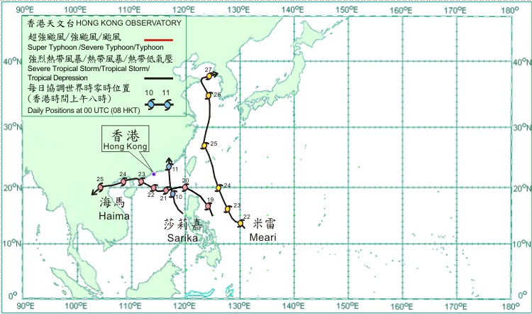
Three tropical cyclones occurred over the western North Pacific and South China Sea in June 2011. Amongst them, Sarika and Haima necessitated the issuance of tropical cyclone warning signals in Hong Kong.
Sarika formed as a tropical depression over the central part of the South China Sea about 650 km south-southeast of Dongsha on 9 June and moved northwestwards. It tracked north-northwestwards and intensified into a tropical storm on the morning of 10 June, reaching its peak intensity with an estimated maximum sustained wind of 65 km/h near its centre. Sarika turned to move northwards across the northeastern part of the South China Sea that afternoon. It made landfall near Shantou on the morning of 11 June and dissipated over Fujian that afternoon.
Haima formed as a tropical depression over the western North Pacific about 420 km east of Manila on 18 June and moved generally northwestwards, crossing the Luzon Strait in the following evening. Haima moved westwards across the northern part of the South China Sea for the following two days. It turned to move west-northwest to northwestwards on 22 June and intensified into a tropical storm, reaching its peak intensity with an estimated maximum sustained wind of 85 km/h near its centre. Haima made landfall over the coast of western Guangdong on 23 June and moved west-southwestwards across the coastal region of western Guangdong subsequently. It moved across Beibu Wan on 24 June and made landfall over the northern coast of Vietnam that evening. Haima dissipated inland over Laos on 25 June.
Meari formed as a tropical depression over the western North Pacific about 1 090 km east-southeast of Manila on 21 June and moved northwestwards. It intensified into a tropical storm on 22 June and moved north-northwestwards the following day. Meari intensified into a severe tropical storm on 24 June and turned to move generally northwards across the East China Sea on 25 June, reaching its peak intensity with an estimated maximum wind of 110 km/h near its centre that day. It weakened into a tropical storm on 26 June, skirting the coast of Shangdong Peninsula that evening. Meari turned to move northeastwards and dissipated over the Korean Peninsula on 27 June. Meari brought flooding to the Philippines where 15 people were missing. It also affected 33 000 hectares of farmland and destroyed 400 houses in the provinces of Liaoning, Zhejiang and Shangdong.

|
