|
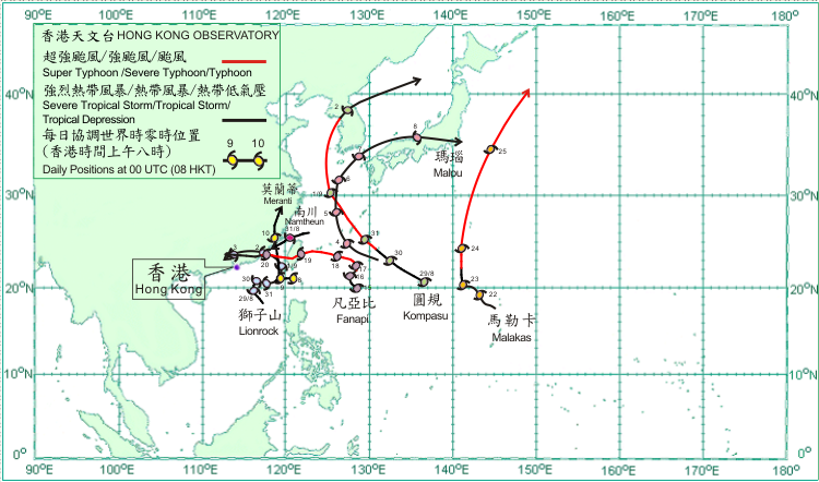
Seven tropical cyclones occurred over the western North Pacific and South China Sea in September 2010. Amongst them, Lionrock and Fanapi necessitated the issuance of tropical cyclone warning signals in Hong Kong.
After forming over the northern part of the South China Sea towards the end of last month, Lionrock gradually intensified into a severe tropical storm. It moved generally northwestwards across the northeastern part of the South China Sea on 1 September. It made landfall over the coast of southern Fujian on 2 September and weakened into a tropical storm. Lionrock then moved generally westwards and subsequently dissipated over Guangdong on 3 September.
After forming over the western North Pacific and gradually intensifying into a typhoon towards the end of last month, Kompasu moved north across the seas to the west of Jeju on 1 September. It turned to move northeastwards crossing the Korean Peninsula and entering the Sea of Japan on 2 September and weakened into a tropical storm. Kompasu became an extra-tropical cyclone over the Sea of Japan the following day. According to press reports, Kompasu caused the death of five people in the Republic of Korea and power cuts to tens of thousands of homes. More than 60 international flights were cancelled or delayed.
Namtheun formed over the East China Sea at the end of last month and intensified into a tropical storm. Moving west-southwestwards, it later weakened into a tropical depression. Namtheun dissipated over the coastal areas of southeastern China to the east of Xiamen on 1 September.
Malou formed over the western North Pacific about 490 km southeast of Okinawa on 3 September and moved west-northwestwards. It intensified into a tropical storm the next day. Malou turned to move northwards on 5 September. It reached its peak intensity with maximum sustained winds of 85 km/h near its centre on 6 September. It turned to move northeastwards that day and crossed the Sea of Japan the following day. Malou then made landfall over central Honshu on 8 September and became an extra-tropical cyclone to the east of Japan on 9 September. According to press reports, an oil rig at Bo Ha was tilted by strong winds to about 45 degrees. All people were rescued to safety.
Meranti formed as a tropical depression about 190 km south-southeast of Gaoxiong on 8 September and moved westwards. It intensified into a tropical storm on 9 September and turned to move northwards. Meranti intensified into a severe tropical storm that evening, reaching its peak intensity with maximum sustained winds of about 110 km/h. Meranti made landfall over the coast of southeast China on 10 September and gradually dissipated over Zhejiang that evening. According to press reports, Meranti triggered landslides in Taitung county in southeastern Taiwan, trapping about 700 people there. In Quanzhou, Fujian, three people were killed and over 350 houses collapsed. The direct economic losses amounted to 100 million RMB.
Fanapi formed as a tropical depression over the western North Pacific about 750 km south of Okinawa on 15 September and moved northwestwards. It intensified into a tropical storm that evening. Fanapi intensified into a severe tropical storm on 16 September and moved northeastwards slowly. It resumed a northwesterly track on 17 September and intensified into a typhoon to the east of Taiwan. Fanapi intensified further into a severe typhoon on 18 September, reaching its peak intensity with estimated maximum sustained winds of 165 km/h near its centre and turning to move generally westwards. It crossed Taiwan on 19 September and weakened into a typhoon. Fanapi crossed the Taiwan Strait that night and made landfall over the coastal areas of southern Fujian on 20 September. Fanapi then gradually weakened and tracked westwards across southern China and finally dissipated near Guangzhou on 21 September.
Malakas formed as a tropical depression over the western North Pacific about 440 km north of Guam on 21 September and moved west-northwestwards. It intensified into a tropical storm the next day. Malakas turned to move northwards on 23 September and gradually intensified into a typhoon on 24 September, reaching its peak intensity with estimated maximum sustained winds of 145 km/h near its centre. It turned to move north-northeastwards on 25 September and became an extra-tropical cyclone to the east of Japan the next day.

|
