|
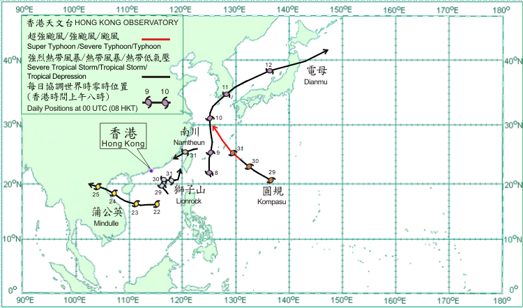
Five tropical cyclones formed over the western North Pacific and South China Sea in August 2010. Amongst them, Lionrock necessitated the issuance of tropical cyclone warning signals in Hong Kong.
On 8 August, Dianmu formed as a tropical depression over the western North Pacific about 580 km southeast of Taibei. It moved northwards and gradually intensified to a severe tropical storm reaching its peak intensity with estimated maximum sustained winds of 90 km/h near its centre on 9 August. It turned to move northeastwards across Jeju and the southeastern part of the Republic of Korea on 11 August. Dianmu moved across the Sea of Japan on 12 August and weakened into a tropical storm. It became an extra-tropical cyclone to the east of Japan the following day. According to press reports, five people were killed and around 130 houses were flooded in the Republic of Korea during the passage of Dianmu.
Mindulle formed as a tropical depression over the northern part of the South China Sea about 300 km east of Xisha on 22 August and moved westwards. It turned west-northwest and intensified gradually into a severe tropical storm the next day. On 24 August, Mindulle reached its peak intensity with estimated maximum sustained winds of 105 km/h near its centre. It moved northwestwards across Beibu Wan that day and made landfall over northern Vietnam in the evening. It subsequently dissipated over Laos on 25 August.
Lionrock formed as a tropical depression over the northern part of the South China Sea about 600 km south-southeast of Hong Kong on 28 August and moved northwestwards. It intensified into a tropical storm the next day and turned to the north. Lionrock moved eastwards on 30 August and intensified into a severe tropical storm with maximum sustained winds of 90 km/h near its centre. Lionrock was moving east-notheastwards over the northeastern part of the South China Sea on 31 August.
Kompasu formed as a tropical depression over the western Pacific about 1 090 km southeast of Okinawa on 29 August and moved northwestwards. Komapsu gradually intensified and became a typhoon to the southeast of Okinawa on 31 August, with maximum sustained winds of 145 km/h near its centre.
Namtheun formed as a tropical depression over the southern part of the East China Sea about 160 km northeast of Taibei on 30 August and moved west-southwestwards. It intensified into a tropical storm that evening, reaching its peak intensity with maximum sustained winds of 65 km/h near its centre. Namtheun moved across the Taiwan Strait on 31 August and weakened into a tropical depression.

|
