|
Three tropical cyclones occurred over the western North Pacific and South China Sea in July 2010. Amongst them, Conson and Chanthu necessitated the issuance of warning signals in Hong Kong.
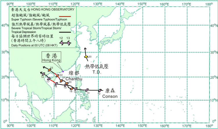
Conson formed as a tropical depression over the western North Pacific about 1 200 km east of Manila early on 12 July. Moving westwards, it intensified into a severe tropical storm that evening. Conson crossed the southern part of Luzon during the night of 13 July. It moved west-northwestwards across the South China Sea on 14 July but took on a more westerly track the following day. Conson moved in a northwest to west-northwest direction on 16 July. It intensified into a typhoon in the afternoon and skirted the coast of southwestern Hainan that night. It crossed Beibu Wan on 17 July, making landfall over the coast of northern Vietnam that evening and gradually weakening into a tropical storm. Conson weakened further into a tropical depression next morning and dissipated inland thereafter.
Chanthu formed as a tropical depression over the central part of the South China Sea about 900 km south-southeast of Hong Kong on 19 July. It moved generally northwestwards across the northern part of the South China Sea. Chanthu intensified into a typhoon to the east of Hainan Island in the early hours of 22 July. Chanthu made landfall near Zhanjiang that afternoon and weakened into a severe tropical storm that evening. It moved across Guangxi on 23 July and eventually dissipated inland that night.
A tropical depression formed over the western North Pacific about 240 km west of Okinawa on 19 July and moved generally north-northwestwards. The estimated maximum winds reached 45 km/h near its centre. The tropical depression dissipated over the East China Sea the next day.
|