|
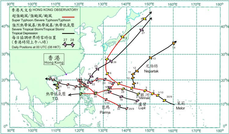
Six tropical cyclones occurred over the northwest Pacific and South China Sea in October 2009. Amongst them, three tropical cyclones, Parma, Melor and Lupit, attained super typhoon intensity while traversing the Pacific. Moreover, Parma which formed over the Pacific late last month and persisted for almost 16 days was the tropical cyclone with the longest life span in the region since Typhoon Verne in 1994. Verne persisted for about 16 days.
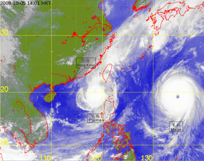
After forming over the northwest Pacific at the end of September, Parma intensified into a severe typhoon about 1,140 km east-southeast of Manila on the morning of 1 October. Moving west-northwestwards, Parma intensified further into a super typhoon that afternoon. It gradually weakened into a typhoon on 2 October and turned to move northwestwards. Parma crossed the northern part of Luzon on 3 October and lingered near northern Luzon in the following four days. Its slow and erratic movement during the period was due to another tropical cyclone, Melor, over the Pacific during that time. Parma weakened into a severe tropical storm on 5 October and gradually weakened into a tropical depression on 7 October. It resumed a westward movement across Luzon on 8 October and re-intensified into a tropical storm. After entering the South China Sea on 9 October, Parma moved west-northwestwards across the northern part of the South China Sea on 10 October. Parma made landfall over the southeastern part of Hainan Island during the afternoon of 12 October, but intensified into a severe tropical storm over Beibu Wan on the following day. It weakened first into a tropical storm on 14 October, and made landfall over northern Vietnam that afternoon and subsequently weakened further into a tropical depression. It dissipated over northern Vietnam during the early hours of 15 October. According to press reports, rainstorms associated with Parma triggering severe flooding and landslides in the Philippines where around 200 people were killed. In Hainan Island, around 540,000 hectares of crops were damaged and the direct economic losses amounted to 51.70 million RMB. Three fishing boats sank in the waters of Hainan Island and the South China Sea, killing four fishermen with eight others missing. A total of 62 fishing boats sank in the seas of Vietnam but no casualties were reported.
After forming over the northwest Pacific towards the end of September, Melor gradually intensified and became a typhoon about 910 km east of Guam on 1 October and continued to move west-northwestwards. It intensified into a severe typhoon on 2 October and became a super typhoon two days later. Melor turned to move northwestwards over the Pacific to the southeast of Okinawa on 6 October. It turned to move north-northeastwards over the Pacific to the south of Kyushu, Japan on 7 October and weakened into a severe typhoon. Melor weakened further into a typhoon on 8 October and made landfall over the southern part of Honshu around daybreak. It further weakened into a severe tropical storm and moved across the eastern part of Honshu thereafter. Melor became an extra-tropical cyclone over the Pacific to the east of Hokkaido on 9 October. In the fury of Melor, four people were killed and more than 100 injured in Japan.
Nepartak formed as a tropical depression over the northwest Pacific about 400 km north-northwest of Guam on 8 October and moved north-northwestwards. It intensified into a tropical storm the next day. Nepartak slowed down on 10 October and turned to move northeastwards on 11 October, passing to the southeast of Iwo Jima. It speeded up towards the northeast on 12 October and became an extra-tropical cyclone over the Pacific to the east of Japan on 14 October.
Lupit formed as a tropical depression over the northwest Pacific about 250 km south of Guam on 15 October and moved west-northwestwards. It intensified first into a tropical storm and then a severe tropical storm on 16 October. Lupit slowed down and turned to move northwards on 17 October. It intensified into a typhoon over the Pacific to the northwest of Yap that day and further into a severe typhoon that evening. Lupit moved slowly northeastwards and became a super typhoon on 18 October. It resumed a mainly westerly track on 19 October, and weakened gradually into a typhoon in the following two days. Lupit became slow moving again over the waters to the northeast of Luzon on 22 October, but turned to move north-northeastwards and weakened into a severe tropical storm on 23 October. It weakened further into a tropical storm on 25 October over the Pacific to the southeast of Okinawa. Lupit moved across the seas to the southeast of Japan on 26 October. It became an extra-tropical cyclone over the Pacific to the east of Hokkaido on 27 October.
A tropical depression formed over the northern part of the South China Sea about 230 km east-northeast of Da Nang on 19 October and moved slowly northwards. The tropical depression dissipated over the waters south of Hainan during the evening of the following day.
Mirinae formed as a tropical depression over the northwest Pacific about 60 km north-northeast of Guam on 27 October and moved west-northwestwards. It intensified into a typhoon over the Pacific to the east of Manila on 28 October and turned to move westwards. Mirinae crossed Luzon and weakened into a severe tropical storm during the small hours of 31 October, and subsequently entered the central part of the South China Sea during the morning. During the passage of Mirinae, at least 20 people were killed and four others injured in the Philippines. Electricity supply to parts of Manila was disrupted.
|

