|
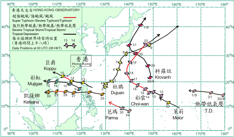
Nine tropical cyclones occurred over the western North Pacific and South China Sea in September 2009. Over the western North Pacific, Choi-Wan became the first super typhoon of the year. Three tropical cyclones, namely Mujigae, Koppu and Ketsana, affected the South China Sea and necessitated the issuance of tropical cyclone warning signals in Hong Kong.
After skirting the eastern coast of Japan on 31 August, Severe Tropical Storm Krovanh weakened into a tropical storm on 1 September and became an extra-tropical cyclone to the east of Hokkaido that evening.
A tropical depression entered the western North Pacific from the central North Pacific at the end of last month. It moved west-northwestwards across the ocean southeast of Wake Island on 1 September and soon dissipated over water.
Dujuan formed as a tropical depression over the western North Pacific about 940 km south-southeast of Okinawa on 3 September and moved slowly at first. It intensified into a tropical storm on 4 September and started to move generally northeastwards across the western North Pacific. Dujuan intensified into a severe tropical storm on 5 September and moved north-northeastwards. It moved east-northeastwards across the waters to the south of Japan on 8 September and weakened into a tropical storm. Dujuan became an extra-tropical cyclone over the western North Pacific to the east of Japan on 10 September.
.
Mujigae developed into a tropical depression over the central part of the South China Sea about 790 km southeast of Hong Kong on the morning of 9 September. It moved northwestwards at first but took on a west-northwesterly track across the northern part of the South China Sea that afternoon. Mujigae intensified into a tropical storm on 10 September over the northern part of the South China Sea to the south-southeast of Hong Kong and turned to move westwards at night. It moved across the northern part of Hainan Island in the small hours of 11 September and entered Beibu Wan that morning. It made landfall over northern Vietnam on the morning of 12 September and weakened into a tropical depression. Mujigae weakened further into an area of low pressure over northern Vietnam that afternoon.
Choi-Wan formed as a tropical depression over the western North Pacific about 940 km east of Guam on 12 September. It moved west-northwestwards and intensified into a tropical storm the next day. On 14 September, Choi-Wan intensified first into a severe tropical storm and became a typhoon over the Pacific to the east-northeast of Guam. It continued to intensify into a severe typhoon on 15 September and further into super typhoon that evening. Choi-Wan weakened into a severe typhoon on 17 September as it turned to move northwestwards. While moving northwards, it weakened into a typhoon southwest of Iwo Jima on the next day. Choi-Wan turned to move northeast on 19 September. It weakened into a severe tropical storm on 20 September and became an extra-tropical cyclone to the east of Japan that evening.
Koppu developed into a tropical depression over the western North Pacific about 490 km northeast of Manila on 12 September. Moving west-northwestwards, it crossed the Luzon Strait that night. Koppu entered the northern part of the South China Sea on a westerly track on the morning of 13 September and intensified into a tropical storm that evening. Koppu became a severe tropical storm on the morning of 14 September and turned to move northwestwards. It intensified into a typhoon about 190 km south-southeast of Hong Kong that afternoon, and took up a west-northwesterly track at night. Koppu made landfall over western Guangdong in the morning and weakened into a severe tropical storm. It weakened further into a tropical storm that afternoon. Koppu weakened into a tropical depression on the small hours of 16 September and dissipated over Guangxi thereafter.
Ketsana formed as a tropical depression over the western North Pacific about 830 km east of Manila on 25 September and moved westwards. Ketsana intensified into a tropical storm and moved across the Philippines on 26 September, entering the South China Sea that evening. Ketsana intensified into a severe tropical storm on 27 September and further into a typhoon over the central part of the South China Sea to the south-southwest of Hong Kong on the next day. Ketsana made landfall over the central part of Vietnam on 29 September and weakened into a severe tropical storm. It weakened first into a tropical storm and further into a tropical depression on 30 September. Ketsana dissipated near the border between Laos and Thailand that night.
Parma developed as a tropical depression over the western North Pacific about 270 km southeast of Yap on 29 September and moved west-northwestwards. It intensified into a tropical storm that evening. Parma intensified first into a severe tropical storm and became a typhoon over the Pacific to the west of Yap on 30 September.
Melor formed as tropical depression over the western North Pacific about 1,750 km east-southeast of Guam on 29 September and moved west-northwestwards and became a tropical storm in the evening. Melor continued to move west-northwestwards across the western North Pacific on 30 September.
|
