Overview of Tropical Cyclones in August 2009
Overview of Tropical Cyclones in August 2009
(Tracks)
|
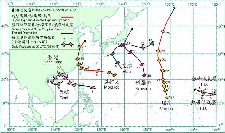
Seven tropical cyclones occurred over the western North Pacific and South China Sea in August 2009. Amongst them, Goni entered the South China Sea and necessitated the issuance of the No. 8 Southeast Gale or Storm Signal in Hong Kong. Goni developed into a tropical depression over the western North Pacific about 720 km east-northeast of Manila on 1 August. Tracking west-northwestwards, it crossed northern Luzon that night and entered the South China Sea the next morning. On 3 August, Goni slowed down and its track became erratic but generally moved towards the coast of Guangdong. Goni intensified into a tropical storm that evening and further into a severe tropical storm on 4 August. It made landfall over western Guangdong on 5 August and weakened into a tropical storm. Goni turned to move west or west-southwestwards across the coastal areas of western Guangdong and weakened into a tropical depression on 6 August. It then moved southwestwards to cross Leizhou Peninsula and entered Beibu Wan on the next day. It intensified into a tropical storm again on 8 August and turned to move eastwards that night. Goni crossed the northern part of the South China Sea on 9 August and weakened rapidly into an area of low pressure over the northern part of the South China Sea that afternoon.
Morakot formed as a tropical depression over the western North Pacific about 1,050 km east-southeast of Okinawa on 4 August. Moving west-northwestwards, it intensified into a tropical storm that day. Morakot intensified first into a severe tropical storm and further into a typhoon on 5 August, and turned to move westwards towards Taiwan on the following day. It slowed down on 7 August and crossed Taiwan on a northwesterly track the next day. Morakot crossed the Taiwan Strait on 9 August and made landfall near Xiapu, Fujian and weakened into a severe tropical storm. It weakened further into a tropical storm on 10 August and moved northwards across eastern China. Morakot turned to move north-northeastwards on the next day and weakened into a tropical depression. It became an extra-tropical cyclone over the Yellow Sea on 12 August. According to press reports, Morakot brought torrential rain to Taiwan, triggering floods and unlashing mudslides, and caused the most severe damage there in about 50 years. More than 460 people were killed, 190 missing and 40 people injured in Taiwan, of which hundreds were buried beneath the rubble in the village of Hsiaolin in southern Taiwan. The agricultural losses in Taiwan exceeded NT15.8 billion, with more than 18,000 hectares of farmland flooded. Moreover, at least six people were killed, three people missing and over 6,000 houses collapsed in Fujian, Zhejiang, Jiangxi and Anhui. The direct economic loss was estimated to be over 9 billion RMB. Etau formed as a tropical depression over the western North Pacific about 260 km west-southwest of Iwo Jima on 8 August and moved northwestwards. It intensified into a tropical storm the next day. Etau turned to move generally northeastwards on 10 August. It moved eastwards on 11 August, skirting the coastal waters of southern Japan. According to press reports, Etau brought heavy rain to Japan causing floods and landslides, inundated a town, and disrupted air and rail links. At least 14 people were killed and 18 people injured. On 13 August, Etau first weakened into a tropical depression and subsequently became an extra-tropical cyclone over the western North Pacific to the east of Japan.
Having formed over the central part of the North Pacific, a tropical depression crossed the International Date Line and entered the western North Pacific on 14 August. It turned to move northwestwards on the next day. The tropical depression weakened into an area of low pressure over the western North Pacific to the east-southeast of Wake Island on 17 August.
Vamco formed as a tropical depression over the western North Pacific about 1,540 km east of Guam on 17 August and moved generally north-northwestwards. Vamco intensified first into a tropical storm and then a severe tropical storm on 18 August, and further into a typhoon the next day. It turned to move northwards on 23 August and north-northeastwards the next day. Vamco weakened into a severe tropical storm on 25 August and became an extra-tropical cyclone over the western North Pacific to the east-northeast of Hokkaido, Japan on the next day.
Krovanh formed as a tropical depression about 820 km east-southeast of Iwo Jima on 28 August and moved north-northwestwards. It intensified into a tropical storm that evening. Krovanh moved northwestwards on the next day and intensified into a severe tropical storm on 30 August. Krovanh turned to move north-northeastwards skirting the eastern coast of Japan on 31 August. Having formed over the central part of the North Pacific, a tropical depression crossed the International Date Line and entered the western North Pacific on 30 August. The tropical depression moved west-northwestwards across the western North Pacific to the southeast of Wake Island on 31 August. |

Tracks of tropical cyclones in August 2009

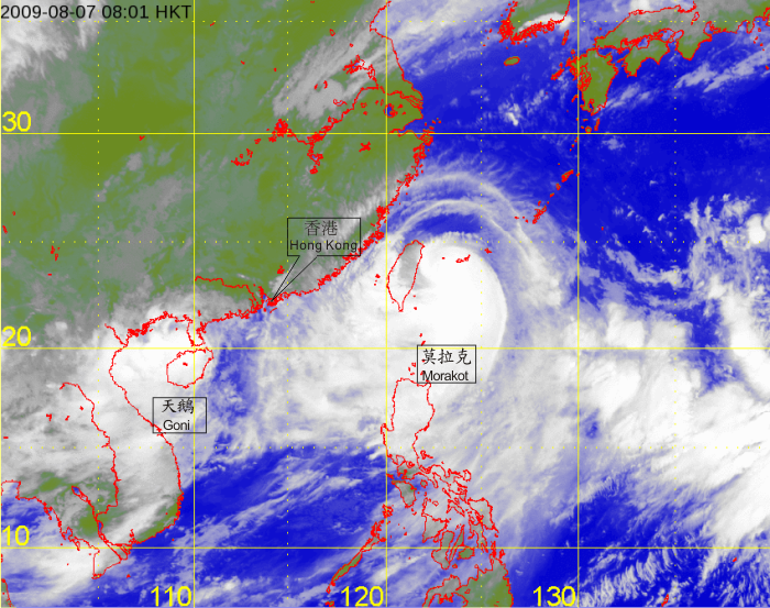
Infra-red satellite imagery at 8 a.m. on 7 August 2009 of Typhoon Morakot and Tropical Depression Goni.
[The satellite imagery was originally captured by the Multi-functional Transport Satellite-1R (MTSAT-1R) of Japan Meteorological Agency (JMA).]