Overview of Tropical Cyclones in June 2009
Overview of Tropical Cyclones in June 2009
(Tracks)
|
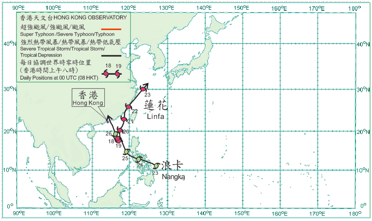
Two tropical cyclones occurred over the western North Pacific and the South China Sea in June 2009, both of which necessitated the issuance of tropical cyclone warning signals in Hong Kong. Tropical Depression Linfa formed over the northern part of the South China Sea about 520 km south-southeast of Hong Kong on 17 June and moved slowly. It intensified into a tropical storm the next day. Linfa started to move northwards on 19 June and intensified into a severe tropical storm that night. Linfa moved north-northeastwards across the northeastern part of the South China Sea on 20 June. It weakened into a tropical storm in the afternoon of 21 June and made landfall in Fujian in the evening. After moving northeastwards across the coast of Fujian on 22 June, Linfa entered the East China Sea and weakened into a tropical depression that evening. It further weakened into an area of low pressure over the East China Sea on 23 June.Tropical Depression Nangka formed over the western North Pacific about 760 km east-southeast of Manila on 23 June. Moving west-northwestwards, it intensified into a tropical storm that evening. Nangka crossed the central Philippines the next day and entered the South China Sea in the evening. Nangka turned to move generally northwestwards across the South China Sea on 25 June. It moved generally north-northwestwards on 26 June approaching the coast of eastern Guangdong and weakened into a tropical depression that evening. Nangka made landfall over the coastal areas of Daya Bay in the small hours of 27 June. Nangka moved further inland and weakened into an area of low pressure over Guangdong that morning. |
