Overview of Tropical Cyclones in September 2008
Overview of Tropical Cyclones in September 2008
(Tracks)
|
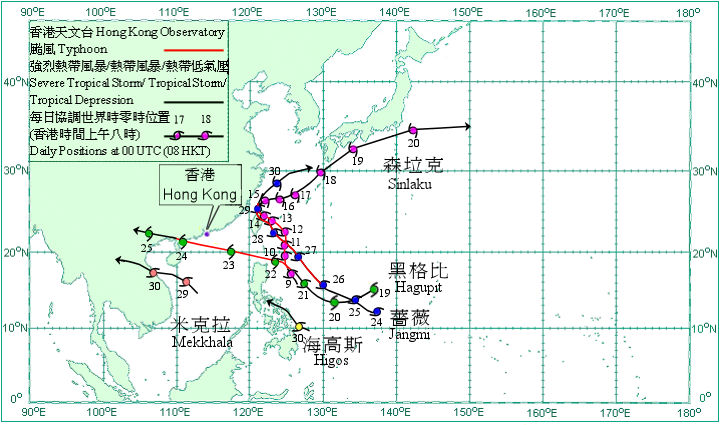
Five tropical cyclones occurred over the western North Pacific and South China Sea in September 2008, of which Hagupit necessitated the issuance of the No. 8 Gale or Storm Signal in Hong Kong. Sinlaku formed as a tropical depression over the western North Pacific about 630 km east of Manila on 8 September and moved north-northwestwards. It intensified first into a tropical storm on 9 September, and further into a severe tropical storm and then a typhoon that day. Sinlaku moved northwards on 11 September but turned to move northwestwards on 12 September. It crossed the northern part of Taiwan on 14 September and weakened into a severe tropical storm that night. According to press reports, Sinlaku caused widespread flooding and triggered landslides in Taiwan, collapsing bridges, tunnels and hotels. At least 11 people were killed and 11 missing, and the direct economic losses were around NT$0.7 billion. Sinlaku turned to move east-northeast over the East China Sea on 15 September and weakened into a tropical storm the next day. It intensified into a severe tropical storm again on 18 September and skirted the southern coasts of Japan. Sinlaku weakened into a tropical storm and subsequently became an extra-tropical cyclone to the east of Japan on 21 September. Hagupit formed as a tropical depression over the western North Pacific about 2540km east-southeast of Hong Kong on 19 September and moved west-southwestwards. It intensified first into a tropical storm on 20 September and moved west-northwestwards and then intensified into a severe tropical storm. Hagupit intensified further into a typhoon on 21 September and moved northwestwards. Moving west-northwestwards, Hagupit crossed the Balintang Channel on 22 September and entered the South China Sea that evening. It crossed the northern part of the South China Sea the next day. Hagupit made landfall in western Guangdong on the morning of 24 September. It weakened into a severe tropical storm that afternoon and a tropical storm thereafter. Hagupit weakened into a tropical depression and further into an area of low pressure over northern Vietnam on 25 September. Jangmi formed as a tropical depression over the western North Pacific about 340 km north-northwest of Yap on 24 September and moved generally west-northwestwards. It intensified into a tropical storm that day and a severe tropical storm the next day. Jangmi intensified further into a typhoon on 26 September and moved northwestwards, and crossed northern Taiwan on the night of 28 September. Jangmi turned to move northwards and weakened into a severe tropical storm on 29 September. It weakened further to a tropical storm that evening and moved northeastwards. According to press reports, at least two people were killed, two missing and 61 injured in Taiwan. Electricity supply to about one million households was disrupted and the agricultural losses were estimated to be about NT$0.3 billion. A freighter sank in the waters of Wenzhou, one crewman was killed and five injured. Jangmi moved east-northeastwards across the East China Sea on 30 September. Mekkhala formed as a tropical depression over the central part of the South China Sea about 270 km south of Xisha on 28 September and moved northwestwards. It intensified into a tropical storm on 29 September. Mekkhala turned to move west-northwestwards and made landfall over the northern part of Vietnam on 30 September. It also weakened into a tropical depression. According to press reports, a fishing boat sank over the waters of Hainan Island but two crewmen on board were rescued. |

Tracks of tropical cyclones in September 2008